
Size of this PNG preview of this SVG file:
600 × 549 pixels. Other resolutions:
262 × 240 pixels |
525 × 480 pixels |
839 × 768 pixels |
1,119 × 1,024 pixels |
2,238 × 2,048 pixels.
Original file (SVG file, nominally 600 × 549 pixels, file size: 13.95 MB)
| This is a file from the
Wikimedia Commons. Information from its
description page there is shown below. Commons is a freely licensed media file repository. You can help. |
Summary
| Description |
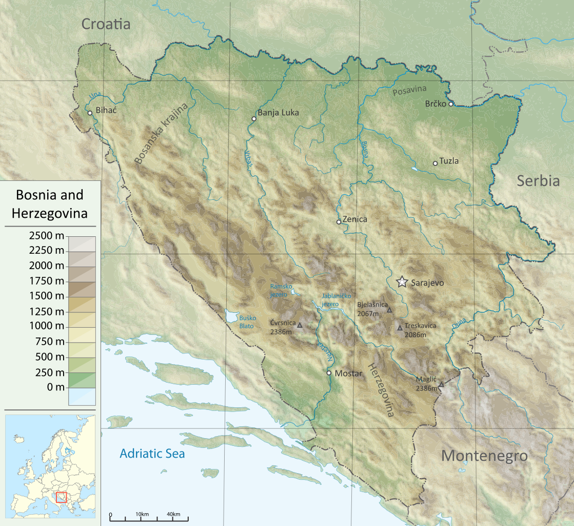
English: Topographic map of Bosnia and Herzegovina |
| Source |
Own work Sources :
Software used :
|
| Author | DzWiki |
| Other versions |
|


W3C-validity not checked.
Licensing
I, the copyright holder of this work, hereby publish it under the following licenses:
This file is licensed under the
Creative Commons
Attribution-Share Alike 3.0 Unported license.
- You are free:
- to share – to copy, distribute and transmit the work
- to remix – to adapt the work
- Under the following conditions:
- attribution – You must give appropriate credit, provide a link to the license, and indicate if changes were made. You may do so in any reasonable manner, but not in any way that suggests the licensor endorses you or your use.
- share alike – If you remix, transform, or build upon the material, you must distribute your contributions under the same or compatible license as the original.

|
Permission is granted to copy, distribute and/or modify this document under the terms of the GNU Free Documentation License, Version 1.2 or any later version published by the Free Software Foundation; with no Invariant Sections, no Front-Cover Texts, and no Back-Cover Texts. A copy of the license is included in the section entitled GNU Free Documentation License. |
You may select the license of your choice.
File history
Click on a date/time to view the file as it appeared at that time.
| Date/Time | Thumbnail | Dimensions | User | Comment | |
|---|---|---|---|---|---|
| current | 17:08, 19 December 2011 |
| 600 × 549 (13.95 MB) | DzWiki | new ver. |
| 12:56, 21 April 2011 |
 | 595 × 597 (3.96 MB) | DzWiki | m | |
| 12:49, 21 April 2011 |
 | 595 × 597 (4.1 MB) | DzWiki | m | |
| 15:27, 18 March 2011 |
 | 595 × 597 (3.56 MB) | DzWiki | m | |
| 16:32, 11 March 2011 |
 | 588 × 554 (3.49 MB) | DzWiki | {{Information |Description ={{en|1=Topographic map of Bosnia and Herzegovina}} |Source ={{own}} |Author = DzWiki |Date = |Permission = |other_versions = }} [[Category:Topographic maps of Bosnia and Herzegov |
File usage
The following pages on the English Wikipedia use this file (pages on other projects are not listed):
Global file usage
The following other wikis use this file:
- Usage on af.wikipedia.org
- Usage on ar.wikipedia.org
- Usage on bn.wikipedia.org
- Usage on bs.wikipedia.org
- Usage on csb.wikipedia.org
- Usage on fa.wikipedia.org
- Usage on fr.wikipedia.org
- Usage on hr.wikipedia.org
- Usage on hr.wiktionary.org
- Usage on hu.wikipedia.org
- Usage on it.wikipedia.org
- Usage on ja.wikipedia.org
- Usage on lt.wikipedia.org
- Usage on mzn.wikipedia.org
- Usage on nn.wikipedia.org
- Usage on rm.wikipedia.org
- Usage on ro.wikipedia.org
- Usage on sd.wikipedia.org
- Usage on te.wikipedia.org
- Usage on uk.wikipedia.org
- Usage on zh.wikipedia.org
Size of this PNG preview of this SVG file:
600 × 549 pixels. Other resolutions:
262 × 240 pixels |
525 × 480 pixels |
839 × 768 pixels |
1,119 × 1,024 pixels |
2,238 × 2,048 pixels.
Original file (SVG file, nominally 600 × 549 pixels, file size: 13.95 MB)
| This is a file from the
Wikimedia Commons. Information from its
description page there is shown below. Commons is a freely licensed media file repository. You can help. |
Summary
| Description |
English: Topographic map of Bosnia and Herzegovina |
| Source |
Own work Sources :
Software used :
|
| Author | DzWiki |
| Other versions |
|
W3C-validity not checked.
Licensing
I, the copyright holder of this work, hereby publish it under the following licenses:
This file is licensed under the
Creative Commons
Attribution-Share Alike 3.0 Unported license.
- You are free:
- to share – to copy, distribute and transmit the work
- to remix – to adapt the work
- Under the following conditions:
- attribution – You must give appropriate credit, provide a link to the license, and indicate if changes were made. You may do so in any reasonable manner, but not in any way that suggests the licensor endorses you or your use.
- share alike – If you remix, transform, or build upon the material, you must distribute your contributions under the same or compatible license as the original.
|
|
Permission is granted to copy, distribute and/or modify this document under the terms of the GNU Free Documentation License, Version 1.2 or any later version published by the Free Software Foundation; with no Invariant Sections, no Front-Cover Texts, and no Back-Cover Texts. A copy of the license is included in the section entitled GNU Free Documentation License. |
You may select the license of your choice.
File history
Click on a date/time to view the file as it appeared at that time.
| Date/Time | Thumbnail | Dimensions | User | Comment | |
|---|---|---|---|---|---|
| current | 17:08, 19 December 2011 |
| 600 × 549 (13.95 MB) | DzWiki | new ver. |
| 12:56, 21 April 2011 |
| 595 × 597 (3.96 MB) | DzWiki | m | |
| 12:49, 21 April 2011 |
| 595 × 597 (4.1 MB) | DzWiki | m | |
| 15:27, 18 March 2011 |
| 595 × 597 (3.56 MB) | DzWiki | m | |
| 16:32, 11 March 2011 |
| 588 × 554 (3.49 MB) | DzWiki | {{Information |Description ={{en|1=Topographic map of Bosnia and Herzegovina}} |Source ={{own}} |Author = DzWiki |Date = |Permission = |other_versions = }} [[Category:Topographic maps of Bosnia and Herzegov |
File usage
The following pages on the English Wikipedia use this file (pages on other projects are not listed):
Global file usage
The following other wikis use this file:
- Usage on af.wikipedia.org
- Usage on ar.wikipedia.org
- Usage on bn.wikipedia.org
- Usage on bs.wikipedia.org
- Usage on csb.wikipedia.org
- Usage on fa.wikipedia.org
- Usage on fr.wikipedia.org
- Usage on hr.wikipedia.org
- Usage on hr.wiktionary.org
- Usage on hu.wikipedia.org
- Usage on it.wikipedia.org
- Usage on ja.wikipedia.org
- Usage on lt.wikipedia.org
- Usage on mzn.wikipedia.org
- Usage on nn.wikipedia.org
- Usage on rm.wikipedia.org
- Usage on ro.wikipedia.org
- Usage on sd.wikipedia.org
- Usage on te.wikipedia.org
- Usage on uk.wikipedia.org
- Usage on zh.wikipedia.org