This is a file from the Wikimedia Commons
From Wikipedia, the free encyclopedia

Original file(2,608 × 2,809 pixels, file size: 335 KB, MIME type: image/png)

This historical map image could be re-created using vector graphics as an SVG file. This has several advantages; see  Commons:Media for cleanup for more information. If an SVG form of this image is available, please upload it and afterwards replace this template with {{ vector version available|new image name}}.


It is recommended to name the SVG file “Banovina of Croatia religious map.svg”—then the template Vector version available (or Vva) does not need the new image name parameter.

Summary

Description
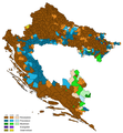
English: Religious map of the Banovina of Croatia, according to the 1931 population census.
Date
Source Own work
Author Tezwoo
Other versions

Licensing

I, the copyright holder of this work, hereby publish it under the following license:
w:en:Creative Commons
attribution share alike
This file is licensed under the Creative Commons Attribution-Share Alike 4.0 International license.
You are free:
  • to share – to copy, distribute and transmit the work
  • to remix – to adapt the work
Under the following conditions:
  • attribution – You must give appropriate credit, provide a link to the license, and indicate if changes were made. You may do so in any reasonable manner, but not in any way that suggests the licensor endorses you or your use.
  • share alike – If you remix, transform, or build upon the material, you must distribute your contributions under the same or compatible license as the original.

Information

Captions

Add a one-line explanation of what this file represents

Items portrayed in this file

depicts

9 June 2018

image/png

4dbaf010a85f84106818c6c312d4b21176a8db7f

343,436 byte

2,809 pixel

2,608 pixel

File history

Click on a date/time to view the file as it appeared at that time.

Date/TimeThumbnailDimensionsUserComment
current 20:12, 17 March 2022 Thumbnail for version as of 20:12, 17 March 20222,608 × 2,809 (335 KB)CehaPromijenio tonalitet boja
17:47, 31 March 2019 Thumbnail for version as of 17:47, 31 March 20192,608 × 2,809 (295 KB)Tezwooadded missing municipalities in Posavina (part of Osinja, Srnice, Špionica, Zelinja, Bosanski Kobaš), removed Kotorsko, fixed religion in Podravska Slatina, minor fixes to other borders
00:48, 21 January 2019 Thumbnail for version as of 00:48, 21 January 20192,608 × 2,809 (317 KB)Tezwoominor fix
18:11, 11 June 2018 Thumbnail for version as of 18:11, 11 June 20182,608 × 2,809 (261 KB)Tezwoominor
14:52, 9 June 2018 Thumbnail for version as of 14:52, 9 June 20182,608 × 2,809 (261 KB)TezwooMinor correction in two municipalities with the same name
14:43, 9 June 2018 Thumbnail for version as of 14:43, 9 June 20182,608 × 2,809 (261 KB)TezwooUser created page with UploadWizard
The following pages on the English Wikipedia use this file (pages on other projects are not listed):

Global file usage

The following other wikis use this file:

Metadata


Videos

Youtube | Vimeo | Bing

Websites

Google | Yahoo | Bing

Encyclopedia

Google | Yahoo | Bing

Facebook