Size of this preview:
800 × 465 pixels. Other resolutions:
320 × 186 pixels |
640 × 372 pixels |
1,024 × 595 pixels |
1,280 × 744 pixels |
2,560 × 1,488 pixels |
4,103 × 2,385 pixels.
Original file (4,103 × 2,385 pixels, file size: 1.97 MB, MIME type: image/jpeg)
| This is a file from the
Wikimedia Commons. Information from its
description page there is shown below. Commons is a freely licensed media file repository. You can help. |
Summary
| Description |
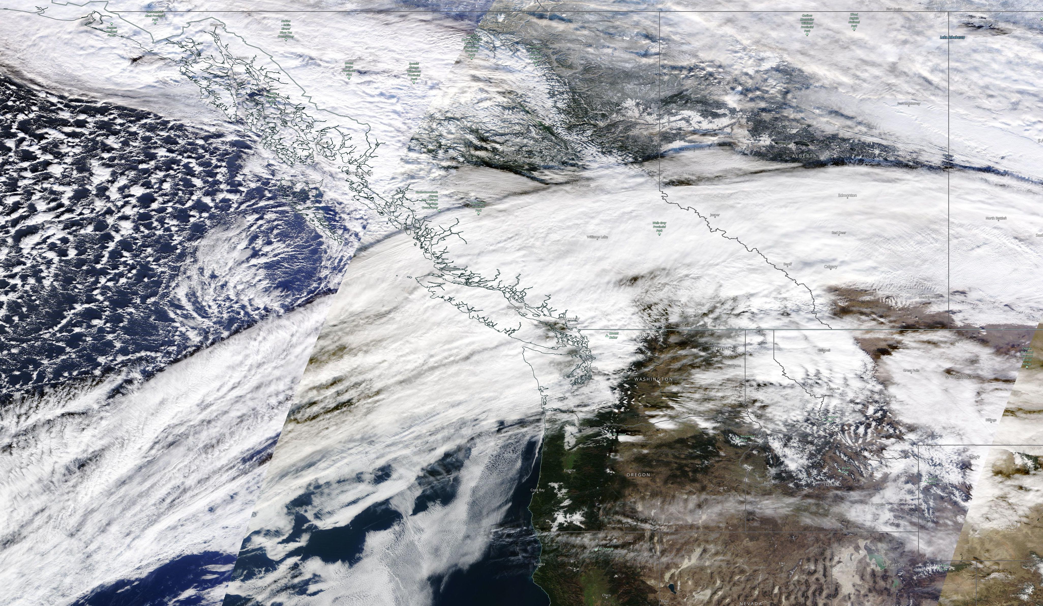
Français : Vue satellite de la tempête de pluie sur la côte ouest de l'Amérique du Nord au 1er décembre 2021 à 00 UTC.
English: Satellite photo of the storm at 00 UTC on Dec. 1st, 2021 that brought floods in BC and WA. |
| Date | |
| Source | EODIS Worldview |
| Author | NASA |
Licensing
| This file is in the public domain in the United States because it was solely created by NASA. NASA copyright policy states that "NASA material is not protected by copyright unless noted". (See Template:PD-USGov, NASA copyright policy page or JPL Image Use Policy.) | ||
 |
Warnings:
|
File history
Click on a date/time to view the file as it appeared at that time.
| Date/Time | Thumbnail | Dimensions | User | Comment | |
|---|---|---|---|---|---|
| current | 00:32, 2 December 2021 |
| 4,103 × 2,385 (1.97 MB) | Pierre cb | Uploaded a work by NASA from [https://wvs.earthdata.nasa.gov/api/v1/snapshot?REQUEST=GetSnapshot&TIME=2021-12-01T00:00:00Z&BBOX=45.242951889210715,215.69041972711312,57.5652997516051,244.524713725116&CRS=EPSG:4326&LAYERS=MODIS_Terra_CorrectedReflectance_TrueColor,Coastlines_15m,Reference_Features_15m,Reference_Labels_15m&WRAP=day,x,x,x&FORMAT=image/jpeg&WIDTH=3281&HEIGHT=1402&ts=1638294747839 EODIS Worldview] with UploadWizard |
File usage
The following pages on the English Wikipedia use this file (pages on other projects are not listed):
Global file usage
The following other wikis use this file:
- Usage on ja.wikipedia.org
Size of this preview:
800 × 465 pixels. Other resolutions:
320 × 186 pixels |
640 × 372 pixels |
1,024 × 595 pixels |
1,280 × 744 pixels |
2,560 × 1,488 pixels |
4,103 × 2,385 pixels.
Original file (4,103 × 2,385 pixels, file size: 1.97 MB, MIME type: image/jpeg)
| This is a file from the
Wikimedia Commons. Information from its
description page there is shown below. Commons is a freely licensed media file repository. You can help. |
Summary
| Description |
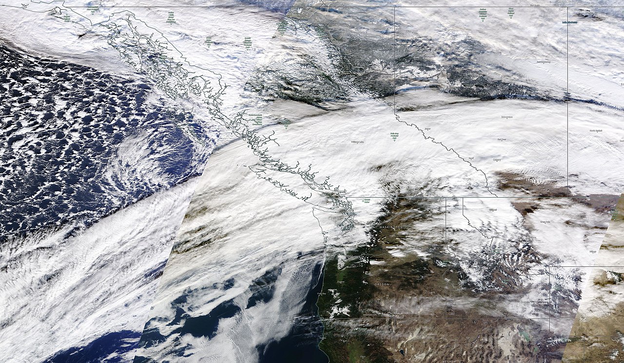
Français : Vue satellite de la tempête de pluie sur la côte ouest de l'Amérique du Nord au 1er décembre 2021 à 00 UTC.
English: Satellite photo of the storm at 00 UTC on Dec. 1st, 2021 that brought floods in BC and WA. |
| Date | |
| Source | EODIS Worldview |
| Author | NASA |
Licensing
| This file is in the public domain in the United States because it was solely created by NASA. NASA copyright policy states that "NASA material is not protected by copyright unless noted". (See Template:PD-USGov, NASA copyright policy page or JPL Image Use Policy.) | ||
|
Warnings:
|
File history
Click on a date/time to view the file as it appeared at that time.
| Date/Time | Thumbnail | Dimensions | User | Comment | |
|---|---|---|---|---|---|
| current | 00:32, 2 December 2021 |
| 4,103 × 2,385 (1.97 MB) | Pierre cb | Uploaded a work by NASA from [https://wvs.earthdata.nasa.gov/api/v1/snapshot?REQUEST=GetSnapshot&TIME=2021-12-01T00:00:00Z&BBOX=45.242951889210715,215.69041972711312,57.5652997516051,244.524713725116&CRS=EPSG:4326&LAYERS=MODIS_Terra_CorrectedReflectance_TrueColor,Coastlines_15m,Reference_Features_15m,Reference_Labels_15m&WRAP=day,x,x,x&FORMAT=image/jpeg&WIDTH=3281&HEIGHT=1402&ts=1638294747839 EODIS Worldview] with UploadWizard |
File usage
The following pages on the English Wikipedia use this file (pages on other projects are not listed):
Global file usage
The following other wikis use this file:
- Usage on ja.wikipedia.org