
Original file (973 × 1,285 pixels, file size: 168 KB, MIME type: image/jpeg)
| This is a file from the
Wikimedia Commons. Information from its
description page there is shown below. Commons is a freely licensed media file repository. You can help. |
Summary
| Description |
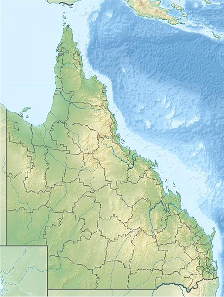
English: Location map of
Queensland,
Australia
Equirectangular projection, N/S stretching 106 %. Geographic limits of the map:
|
| Date | |
| Source | Own work |
| Author | Uwe Dedering |
| Other versions |
|

Licensing
- You are free:
- to share – to copy, distribute and transmit the work
- to remix – to adapt the work
- Under the following conditions:
- attribution – You must give appropriate credit, provide a link to the license, and indicate if changes were made. You may do so in any reasonable manner, but not in any way that suggests the licensor endorses you or your use.
- share alike – If you remix, transform, or build upon the material, you must distribute your contributions under the same or compatible license as the original.

|
Permission is granted to copy, distribute and/or modify this document under the terms of the GNU Free Documentation License, Version 1.2 or any later version published by the Free Software Foundation; with no Invariant Sections, no Front-Cover Texts, and no Back-Cover Texts. A copy of the license is included in the section entitled GNU Free Documentation License. |
File history
Click on a date/time to view the file as it appeared at that time.
| Date/Time | Thumbnail | Dimensions | User | Comment | |
|---|---|---|---|---|---|
| current | 21:49, 5 March 2010 |
| 973 × 1,285 (168 KB) | Uwe Dedering | {{Information |Description={{en|1=Location map of Queensland, Australia Equirectangular projection, N/S stretching 106 %. Geographic limits of the map: * N: 9.0° S * S: 29.5° S * W: 137.5° E * E: 154.0° E Borders |
File usage
More than 100 pages use this file. The following list shows the first 100 pages that use this file only. A full list is available.
- Auburn River National Park
- Balonne River
- Bendidee National Park
- Blackbraes National Park
- Blackdown Tableland National Park
- Bladensburg National Park
- Bowling Green Bay National Park
- Brisbane River
- Broad Sound Islands National Park
- Burdekin River
- Burnett River
- Cairns
- Calliope River
- Cania Gorge National Park
- Coalstoun Lakes National Park
- Condamine River
- Conondale National Park
- Conway National Park
- Culgoa Floodplain National Park
- Currawinya National Park
- Daarrba National Park (Cape York Peninsula Aboriginal Land)
- Dalrymple National Park
- Davies Creek National Park
- Diamantina National Park
- Endeavour River National Park
- Errk Oykangand National Park
- Expedition National Park
- Fairlies Knob National Park
- Fitzroy Island National Park
- Fitzroy River (Queensland)
- Forty Mile Scrub National Park
- Frankland Group National Park
- Girramay National Park
- Girringun National Park
- Gold Coast, Queensland
- Goneaway National Park
- Goodedulla National Park
- Great Barrier Reef Marine Park
- Great Sandy National Park
- Grey Peaks National Park
- Hann Tableland National Park
- Hasties Swamp National Park
- Holbourne Island National Park
- Hope Islands National Park
- Idalia National Park
- Isla Gorge National Park
- Japoon National Park
- Keppel Bay Islands National Park
- Kroombit Tops National Park
- Kutini-Payamu (Iron Range) National Park
- Lake Bindegolly National Park
- Lamington National Park
- Littabella National Park
- Lizard Island
- Lochern National Park
- Logan River
- Macintyre River
- Main Range National Park
- Mazeppa National Park
- Maʼalpiku Island National Park
- Mitchell River (Queensland)
- Molle Islands National Park
- Mooloolah River National Park
- Moorrinya National Park
- Moreton Bay
- Moreton Island
- Mount Archer National Park
- Mount Barney (Queensland)
- Mount Bartle Frere
- Mount Etna Caves National Park
- Mount French (Queensland)
- Mount Lindesay (Queensland)
- Mount Superbus
- Nerang River
- Ngalba Bulal National Park
- Nicoll Scrub National Park
- Orpheus Island National Park
- Paluma Range National Park
- Porcupine Gorge National Park
- Riversleigh World Heritage Area
- Rocky Islets National Park
- Round Top Island National Park
- Russell River National Park
- Sarabah National Park
- South Cumberland Islands National Park
- South Island National Park
- Southwood National Park
- Spicers Peak
- Springbrook National Park
- Sundown National Park
- Sunshine Coast, Queensland
- Taunton National Park
- The Palms National Park
- Thrushton National Park
- Two Islands National Park
- Venman Bushland National Park
- Wallaman Falls
- Welford National Park
- Wet Tropics of Queensland
- Wild Cattle Island National Park
View more links to this file.
Global file usage
The following other wikis use this file:
- Usage on als.wikipedia.org
- Usage on ar.wikipedia.org
- Usage on ast.wikipedia.org
- Usage on azb.wikipedia.org
- Usage on ban.wikipedia.org
- Usage on ba.wikipedia.org
- Usage on be.wikipedia.org
- Usage on bg.wikipedia.org
- Usage on bh.wikipedia.org
- Usage on bn.wikipedia.org
- Usage on ceb.wikipedia.org
- Usage on cs.wikipedia.org
- Usage on da.wikipedia.org
- Usage on de.wikipedia.org
- K’gari
- Dunk Island
- Lamington-Nationalpark
- Daintree-Nationalpark
- Cape York (Australien)
- Endeavour-Straße
- Prince-of-Wales-Insel (Queensland)
- Atherton Tablelands
- Whitsunday-Islands-Nationalpark
- Great-Sandy-Nationalpark
- Glass-House-Mountains-Nationalpark
- Magnetic Island
- Whitsunday Islands
- St.-Helena-Island-Nationalpark
- Green Island (Queensland)
View more global usage of this file.
Metadata
Original file (973 × 1,285 pixels, file size: 168 KB, MIME type: image/jpeg)
| This is a file from the
Wikimedia Commons. Information from its
description page there is shown below. Commons is a freely licensed media file repository. You can help. |
Summary
| Description |
English: Location map of
Queensland,
Australia
Equirectangular projection, N/S stretching 106 %. Geographic limits of the map:
|
| Date | |
| Source | Own work |
| Author | Uwe Dedering |
| Other versions |
|
Licensing
- You are free:
- to share – to copy, distribute and transmit the work
- to remix – to adapt the work
- Under the following conditions:
- attribution – You must give appropriate credit, provide a link to the license, and indicate if changes were made. You may do so in any reasonable manner, but not in any way that suggests the licensor endorses you or your use.
- share alike – If you remix, transform, or build upon the material, you must distribute your contributions under the same or compatible license as the original.
|
|
Permission is granted to copy, distribute and/or modify this document under the terms of the GNU Free Documentation License, Version 1.2 or any later version published by the Free Software Foundation; with no Invariant Sections, no Front-Cover Texts, and no Back-Cover Texts. A copy of the license is included in the section entitled GNU Free Documentation License. |
File history
Click on a date/time to view the file as it appeared at that time.
| Date/Time | Thumbnail | Dimensions | User | Comment | |
|---|---|---|---|---|---|
| current | 21:49, 5 March 2010 |
| 973 × 1,285 (168 KB) | Uwe Dedering | {{Information |Description={{en|1=Location map of Queensland, Australia Equirectangular projection, N/S stretching 106 %. Geographic limits of the map: * N: 9.0° S * S: 29.5° S * W: 137.5° E * E: 154.0° E Borders |
File usage
More than 100 pages use this file. The following list shows the first 100 pages that use this file only. A full list is available.
- Auburn River National Park
- Balonne River
- Bendidee National Park
- Blackbraes National Park
- Blackdown Tableland National Park
- Bladensburg National Park
- Bowling Green Bay National Park
- Brisbane River
- Broad Sound Islands National Park
- Burdekin River
- Burnett River
- Cairns
- Calliope River
- Cania Gorge National Park
- Coalstoun Lakes National Park
- Condamine River
- Conondale National Park
- Conway National Park
- Culgoa Floodplain National Park
- Currawinya National Park
- Daarrba National Park (Cape York Peninsula Aboriginal Land)
- Dalrymple National Park
- Davies Creek National Park
- Diamantina National Park
- Endeavour River National Park
- Errk Oykangand National Park
- Expedition National Park
- Fairlies Knob National Park
- Fitzroy Island National Park
- Fitzroy River (Queensland)
- Forty Mile Scrub National Park
- Frankland Group National Park
- Girramay National Park
- Girringun National Park
- Gold Coast, Queensland
- Goneaway National Park
- Goodedulla National Park
- Great Barrier Reef Marine Park
- Great Sandy National Park
- Grey Peaks National Park
- Hann Tableland National Park
- Hasties Swamp National Park
- Holbourne Island National Park
- Hope Islands National Park
- Idalia National Park
- Isla Gorge National Park
- Japoon National Park
- Keppel Bay Islands National Park
- Kroombit Tops National Park
- Kutini-Payamu (Iron Range) National Park
- Lake Bindegolly National Park
- Lamington National Park
- Littabella National Park
- Lizard Island
- Lochern National Park
- Logan River
- Macintyre River
- Main Range National Park
- Mazeppa National Park
- Maʼalpiku Island National Park
- Mitchell River (Queensland)
- Molle Islands National Park
- Mooloolah River National Park
- Moorrinya National Park
- Moreton Bay
- Moreton Island
- Mount Archer National Park
- Mount Barney (Queensland)
- Mount Bartle Frere
- Mount Etna Caves National Park
- Mount French (Queensland)
- Mount Lindesay (Queensland)
- Mount Superbus
- Nerang River
- Ngalba Bulal National Park
- Nicoll Scrub National Park
- Orpheus Island National Park
- Paluma Range National Park
- Porcupine Gorge National Park
- Riversleigh World Heritage Area
- Rocky Islets National Park
- Round Top Island National Park
- Russell River National Park
- Sarabah National Park
- South Cumberland Islands National Park
- South Island National Park
- Southwood National Park
- Spicers Peak
- Springbrook National Park
- Sundown National Park
- Sunshine Coast, Queensland
- Taunton National Park
- The Palms National Park
- Thrushton National Park
- Two Islands National Park
- Venman Bushland National Park
- Wallaman Falls
- Welford National Park
- Wet Tropics of Queensland
- Wild Cattle Island National Park
View more links to this file.
Global file usage
The following other wikis use this file:
- Usage on als.wikipedia.org
- Usage on ar.wikipedia.org
- Usage on ast.wikipedia.org
- Usage on azb.wikipedia.org
- Usage on ban.wikipedia.org
- Usage on ba.wikipedia.org
- Usage on be.wikipedia.org
- Usage on bg.wikipedia.org
- Usage on bh.wikipedia.org
- Usage on bn.wikipedia.org
- Usage on ceb.wikipedia.org
- Usage on cs.wikipedia.org
- Usage on da.wikipedia.org
- Usage on de.wikipedia.org
- K’gari
- Dunk Island
- Lamington-Nationalpark
- Daintree-Nationalpark
- Cape York (Australien)
- Endeavour-Straße
- Prince-of-Wales-Insel (Queensland)
- Atherton Tablelands
- Whitsunday-Islands-Nationalpark
- Great-Sandy-Nationalpark
- Glass-House-Mountains-Nationalpark
- Magnetic Island
- Whitsunday Islands
- St.-Helena-Island-Nationalpark
- Green Island (Queensland)
View more global usage of this file.