Size of this preview:
458 × 600 pixels. Other resolutions:
183 × 240 pixels |
366 × 480 pixels |
766 × 1,003 pixels.
Original file (766 × 1,003 pixels, file size: 168 KB, MIME type: image/png)
| This is a file from the
Wikimedia Commons. Information from its
description page there is shown below. Commons is a freely licensed media file repository. You can help. |

|
This map image could be re-created using
vector graphics as an
SVG file. This has several advantages; see
Commons:Media for cleanup for more information. If an SVG form of this image is available, please upload it and afterwards replace this template with
{{
vector version available|new image name}}
.
It is recommended to name the SVG file “Audencias of Viceroyalty of Peru.svg”—then the template Vector version available (or Vva) does not need the new image name parameter. |
Summary
| Description |
Čeština: Až do 18. století byla španělská část Jižní Ameriky soustředěna do jednoho místokrálovství Peru.
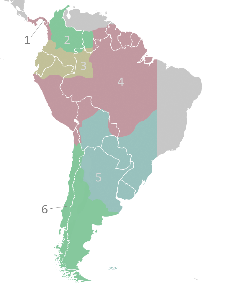
English: The audiencias of the Viceroyalty of Peru c.1650. Territorial divisions of the Viceroyalty of Peru as described by the laws compiled in the Recopilación of 1680.
Italiano: Le audiencias del Vicereame del Perù (1650 circa). Quella di Charcas è nella sezione 2[1].
Lietuvių: Vicekaralystės audiencijos.
1. Panamá2. Santa Fé de Bogotá 3. Quito 4. Lima 5. La Plata de Los Charcas 6. Chile |
| Date | 18 April 2008 (original upload date) |
| Source | Transferred from en.wikipedia to Commons by Jalo using CommonsHelper. |
| Author | Vivaperucarajo at English Wikipedia |
Licensing
Vivaperucarajo at
English Wikipedia, the copyright holder of this work, hereby publishes it under the following license:
This file is licensed under the
Creative Commons
Attribution-Share Alike 2.5 Generic license.
Attribution:
Vivaperucarajo at
English Wikipedia
- You are free:
- to share – to copy, distribute and transmit the work
- to remix – to adapt the work
- Under the following conditions:
- attribution – You must give appropriate credit, provide a link to the license, and indicate if changes were made. You may do so in any reasonable manner, but not in any way that suggests the licensor endorses you or your use.
- share alike – If you remix, transform, or build upon the material, you must distribute your contributions under the same or compatible license as the original.
Original upload log
The original description page was
here. All following user names refer to en.wikipedia.
- 2008-04-18 01:56 Vivaperucarajo 331×446× (19530 bytes) {{self|cc-by-sa-2.5}} [[Category:Locator maps of former territories|Peru, Viceroyalty of]] [[Category:Maps of subdivisions of the Viceroyalty of Peru]]
File history
Click on a date/time to view the file as it appeared at that time.
| Date/Time | Thumbnail | Dimensions | User | Comment | |
|---|---|---|---|---|---|
| current | 17:27, 22 November 2022 |
| 766 × 1,003 (168 KB) | Janitoalevic | Reverted to version as of 03:41, 23 August 2022 (UTC) |
| 00:30, 1 September 2022 |
 | 766 × 1,003 (168 KB) | Floppa Historico | Reverted to version as of 22:21, 7 July 2022 (UTC) | |
| 03:41, 23 August 2022 |
 | 766 × 1,003 (168 KB) | Janitoalevic | . | |
| 22:21, 7 July 2022 |
 | 766 × 1,003 (168 KB) | Janitoalevic | Límite entre Chile y Perú en el río Loa | |
| 23:57, 30 April 2018 |
 | 766 × 1,003 (128 KB) | Janitoalevic | Fixed borders | |
| 02:53, 22 February 2010 |
 | 766 × 1,003 (167 KB) | AniRaptor2001 | Added lines between 1, 6 and countries | |
| 02:50, 22 February 2010 |
 | 766 × 1,003 (166 KB) | AniRaptor2001 | New base file, new colors | |
| 13:53, 27 April 2009 |
 | 331 × 446 (19 KB) | File Upload Bot (Magnus Manske) | {{BotMoveToCommons|en.wikipedia|year={{subst:CURRENTYEAR}}|month={{subst:CURRENTMONTHNAME}}|day={{subst:CURRENTDAY}}}} {{Information |Description={{en|''no original description''}} |Source=Transferred from [http://en.wikipedia.org en.wikipedia]; transfer |
File usage
The following pages on the English Wikipedia use this file (pages on other projects are not listed):
Global file usage
The following other wikis use this file:
- Usage on ast.wikipedia.org
- Usage on ca.wikipedia.org
- Usage on cs.wikipedia.org
- Usage on de.wikipedia.org
- Usage on es.wikipedia.org
- Historia de la Argentina
- Virreinato del Perú
- Anexo:Gobernantes de Argentina
- Real Audiencia de Santafé de Bogotá
- Real Audiencia de Panamá
- Organización territorial del virreinato del Perú
- Conflicto limítrofe entre Bolivia y Perú
- Cabildo de Buenos Aires (institución)
- Estados andinos
- Juan José Romualdo Rocha
- Usage on fi.wikipedia.org
- Usage on it.wikipedia.org
- Usage on lez.wikipedia.org
- Usage on lt.wikipedia.org
- Usage on pl.wikipedia.org
- Usage on ro.wikipedia.org
- Usage on sh.wikipedia.org
- Usage on sk.wikipedia.org
- Usage on sr.wikipedia.org
- Usage on sv.wikipedia.org
- Usage on uk.wikipedia.org
- Usage on vi.wikipedia.org
- Usage on zh.wikipedia.org
Metadata
Size of this preview:
458 × 600 pixels. Other resolutions:
183 × 240 pixels |
366 × 480 pixels |
766 × 1,003 pixels.
Original file (766 × 1,003 pixels, file size: 168 KB, MIME type: image/png)
| This is a file from the
Wikimedia Commons. Information from its
description page there is shown below. Commons is a freely licensed media file repository. You can help. |
|
|
This map image could be re-created using
vector graphics as an
SVG file. This has several advantages; see
Commons:Media for cleanup for more information. If an SVG form of this image is available, please upload it and afterwards replace this template with
{{
vector version available|new image name}}
.
It is recommended to name the SVG file “Audencias of Viceroyalty of Peru.svg”—then the template Vector version available (or Vva) does not need the new image name parameter. |
Summary
| Description |
Čeština: Až do 18. století byla španělská část Jižní Ameriky soustředěna do jednoho místokrálovství Peru.
English: The audiencias of the Viceroyalty of Peru c.1650. Territorial divisions of the Viceroyalty of Peru as described by the laws compiled in the Recopilación of 1680.
Italiano: Le audiencias del Vicereame del Perù (1650 circa). Quella di Charcas è nella sezione 2[1].
Lietuvių: Vicekaralystės audiencijos.
1. Panamá2. Santa Fé de Bogotá 3. Quito 4. Lima 5. La Plata de Los Charcas 6. Chile |
| Date | 18 April 2008 (original upload date) |
| Source | Transferred from en.wikipedia to Commons by Jalo using CommonsHelper. |
| Author | Vivaperucarajo at English Wikipedia |
Licensing
Vivaperucarajo at
English Wikipedia, the copyright holder of this work, hereby publishes it under the following license:
This file is licensed under the
Creative Commons
Attribution-Share Alike 2.5 Generic license.
Attribution:
Vivaperucarajo at
English Wikipedia
- You are free:
- to share – to copy, distribute and transmit the work
- to remix – to adapt the work
- Under the following conditions:
- attribution – You must give appropriate credit, provide a link to the license, and indicate if changes were made. You may do so in any reasonable manner, but not in any way that suggests the licensor endorses you or your use.
- share alike – If you remix, transform, or build upon the material, you must distribute your contributions under the same or compatible license as the original.
Original upload log
The original description page was
here. All following user names refer to en.wikipedia.
- 2008-04-18 01:56 Vivaperucarajo 331×446× (19530 bytes) {{self|cc-by-sa-2.5}} [[Category:Locator maps of former territories|Peru, Viceroyalty of]] [[Category:Maps of subdivisions of the Viceroyalty of Peru]]
File history
Click on a date/time to view the file as it appeared at that time.
| Date/Time | Thumbnail | Dimensions | User | Comment | |
|---|---|---|---|---|---|
| current | 17:27, 22 November 2022 |
| 766 × 1,003 (168 KB) | Janitoalevic | Reverted to version as of 03:41, 23 August 2022 (UTC) |
| 00:30, 1 September 2022 |
| 766 × 1,003 (168 KB) | Floppa Historico | Reverted to version as of 22:21, 7 July 2022 (UTC) | |
| 03:41, 23 August 2022 |
| 766 × 1,003 (168 KB) | Janitoalevic | . | |
| 22:21, 7 July 2022 |
| 766 × 1,003 (168 KB) | Janitoalevic | Límite entre Chile y Perú en el río Loa | |
| 23:57, 30 April 2018 |
| 766 × 1,003 (128 KB) | Janitoalevic | Fixed borders | |
| 02:53, 22 February 2010 |
| 766 × 1,003 (167 KB) | AniRaptor2001 | Added lines between 1, 6 and countries | |
| 02:50, 22 February 2010 |
| 766 × 1,003 (166 KB) | AniRaptor2001 | New base file, new colors | |
| 13:53, 27 April 2009 |
| 331 × 446 (19 KB) | File Upload Bot (Magnus Manske) | {{BotMoveToCommons|en.wikipedia|year={{subst:CURRENTYEAR}}|month={{subst:CURRENTMONTHNAME}}|day={{subst:CURRENTDAY}}}} {{Information |Description={{en|''no original description''}} |Source=Transferred from [http://en.wikipedia.org en.wikipedia]; transfer |
File usage
The following pages on the English Wikipedia use this file (pages on other projects are not listed):
Global file usage
The following other wikis use this file:
- Usage on ast.wikipedia.org
- Usage on ca.wikipedia.org
- Usage on cs.wikipedia.org
- Usage on de.wikipedia.org
- Usage on es.wikipedia.org
- Historia de la Argentina
- Virreinato del Perú
- Anexo:Gobernantes de Argentina
- Real Audiencia de Santafé de Bogotá
- Real Audiencia de Panamá
- Organización territorial del virreinato del Perú
- Conflicto limítrofe entre Bolivia y Perú
- Cabildo de Buenos Aires (institución)
- Estados andinos
- Juan José Romualdo Rocha
- Usage on fi.wikipedia.org
- Usage on it.wikipedia.org
- Usage on lez.wikipedia.org
- Usage on lt.wikipedia.org
- Usage on pl.wikipedia.org
- Usage on ro.wikipedia.org
- Usage on sh.wikipedia.org
- Usage on sk.wikipedia.org
- Usage on sr.wikipedia.org
- Usage on sv.wikipedia.org
- Usage on uk.wikipedia.org
- Usage on vi.wikipedia.org
- Usage on zh.wikipedia.org