
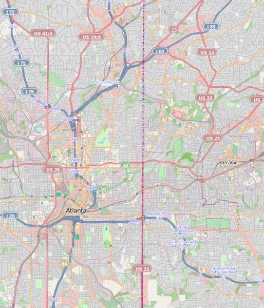
Original file (589 × 687 pixels, file size: 500 KB, MIME type: image/png)
| This is a file from the
Wikimedia Commons. Information from its
description page there is shown below. Commons is a freely licensed media file repository. You can help. |
| Description |
This map was created from OpenStreetMap project data, collected by the community. This map may be incomplete, and may contain errors. Don't rely solely on it for navigation.
|
||||||||||||
| Date | (see file history) | ||||||||||||
| Source | openstreetmap.org | ||||||||||||
| Author | OpenStreetMap contributors | ||||||||||||
| Permission ( Reusing this file) |
All OpenStreetMap data and maps are Creative Commons "CC-BY-SA 2.0" licensed This file is licensed under the
Creative Commons
Attribution-Share Alike 2.0 Generic license.
|
||||||||||||
Atlanta Central.png == Usage == * This template can be used without any parameter, but it also supports setting the source=, the date=, the authors=, location= and the other_versions=. If source is not used the parameter name has to be used. * The parameters top=, bottom=, left=, and right= can be used to store the border coordinates of the map. This information can be useful for various mapping templates that are used in various Wikimedia projects. Atlanta Central.pngCategory:Internationalization templates using LangSwitch
File history
Click on a date/time to view the file as it appeared at that time.
| Date/Time | Thumbnail | Dimensions | User | Comment | |
|---|---|---|---|---|---|
| current | 22:42, 16 March 2011 |
| 589 × 687 (500 KB) | Keizers | updated |
| 17:37, 16 March 2011 |
 | 580 × 707 (671 KB) | Keizers | ({{Information |Description={{LangSwitch |de=Diese Karte {{#if: {{{location|}}}|von {{{location}}} }} entstammt dem offenen OpenStreetMap Projekt, erstellt von der Community. <small>Diese Karte kann unvollständig sein oder Fehler enthalten. Verlasse dich |
File usage
More than 100 pages use this file. The following list shows the first 100 pages that use this file only. A full list is available.
- 1010 Midtown
- 1180 Peachtree
- Academy of Medicine (Atlanta)
- Ansley Park
- Apartments at 22–24 Collier Road
- Apartments at 2 Collier Road
- Atkins Park
- Atlanta Biltmore Hotel and Biltmore Apartments
- Atlanta City Hall
- Atlanta Civic Center
- Atlanta Constitution Building
- Atlanta Cyclorama & Civil War Museum
- Atlanta History Center
- Baltimore Block
- Bankhead, Atlanta
- BeltLine
- Bobby Dodd Stadium
- Booker T. Washington High School (Georgia)
- Briarcliff (mansion)
- Briarcliff Hotel
- Brookwood Hills
- Burns Cottage (Atlanta)
- Cabbagetown, Atlanta
- Callanwolde Fine Arts Center
- Candler Park
- Castleberry Hill
- Center for Puppetry Arts
- Congregation Beth Jacob (Atlanta)
- Decatur Cemetery
- Decatur Waterworks
- Dixie Coca-Cola Bottling Company Plant
- Druid Hills Historic District (Atlanta, Georgia)
- Edward C. Peters House
- Ellis Hotel
- Emory Grove Historic District
- Episcopal Cathedral of Saint Philip (Atlanta)
- Fairlie–Poplar, Atlanta
- Fernbank Science Center
- Ford Motor Company Assembly Plant (Atlanta)
- Fountain Hall
- Fulton County Courthouse (Georgia)
- Garden Hills
- Georgia Governor's Mansion
- Georgia Institute of Technology Historic District
- Georgia State Capitol
- Georgia Tech
- Georgian Terrace Hotel
- Grant Park, Atlanta
- Gresham Park, Georgia
- Herndon Building
- Herndon Home
- Hurt Building
- Inman Park
- Inman Park–Moreland Historic District
- Joel Chandler Harris House
- Just Us, Atlanta
- Knight Park–Howell Station
- Knox Apartments, Cauthorn House and Peachtree Road Apartments Historic District
- Lakewood Heights, Atlanta
- List of tallest buildings in Atlanta
- Martin Luther King Jr. National Historical Park
- Mary Mac's Tea Room
- Mechanicsville, Atlanta
- Medical Arts Building (Atlanta)
- Midtown Atlanta
- Midtown Historic District (Atlanta)
- Mozley Park
- National NuGrape Company
- North Decatur, Georgia
- North Druid Hills, Georgia
- Oakland Cemetery (Atlanta)
- Oakland City, Atlanta
- Old Scottish Rite Hospital building
- Peoplestown
- Piedmont Heights, Atlanta
- Pittsburgh, Atlanta
- Ponce City Market
- Ponce de Leon Court Historic District
- Promenade II
- Pythagoras Lodge No. 41, Free and Accepted Masons
- Reynoldstown, Atlanta
- Rhodes Hall
- Rhodes–Haverty Building
- Rufus M. Rose House
- Smith Farm (Atlanta)
- South Candler Street–Agnes Scott College Historic District
- Southern Bell Telephone Company Building
- State Farm Arena
- Summerhill, Atlanta
- Swan House (Atlanta)
- Sweet Auburn
- Sweet Auburn Curb Market
- TWELVE Centennial Park
- Techwood Homes
- The Texas (locomotive)
- Tower Square (Atlanta)
- University Park–Emory Highlands–Emory Estates Historic District
- Venues of the 1996 Summer Olympics
- Washington Park, Atlanta
- West End, Atlanta
View more links to this file.
Global file usage
The following other wikis use this file:
- Usage on ar.wikipedia.org
- Usage on arz.wikipedia.org
- Usage on ban.wikipedia.org
- Usage on ceb.wikipedia.org
- Usage on fa.wikipedia.org
- Usage on fr.wikipedia.org
- High Museum of Art
- Basket-ball aux Jeux olympiques d'été de 1996
- Turner Field
- Georgia World Congress Center
- Omni Coliseum
- Centre d'histoire d'Atlanta
- Swan House
- World of Coca-Cola
- 1100 Peachtree
- Tech Tower
- Consulat général de France à Atlanta
- Marriott Marquis Hotel
- GLG Grand
- Modèle:Géolocalisation/Atlanta
- ViewPoint
- Peachtree Summit
- Oakland Cemetery
- Module:Carte/données/atlanta
- Grady Memorial Hospital
- Wachovia Plaza
- Modèle:Carte/Atlanta
- Tournoi de tennis d'Atlanta (ATP 2017)
- Goizueta Business School
- Tournoi de tennis d'Atlanta (ATP 2018)
- Pénitencier fédéral d'Atlanta
- Tournoi de tennis d'Atlanta (ATP 2019)
- Cathédrale épiscopalienne Saint-Philippe d'Atlanta
- Agence du registre des substances toxiques et des maladies
- Tournoi de tennis d'Atlanta (ATP 2021)
- Tournoi de tennis d'Atlanta (ATP 2022)
- Tournoi de tennis d'Atlanta (ATP 2023)
- Usage on fy.wikipedia.org
- Usage on he.wikipedia.org
View more global usage of this file.
Original file (589 × 687 pixels, file size: 500 KB, MIME type: image/png)
| This is a file from the
Wikimedia Commons. Information from its
description page there is shown below. Commons is a freely licensed media file repository. You can help. |
| Description |
This map was created from OpenStreetMap project data, collected by the community. This map may be incomplete, and may contain errors. Don't rely solely on it for navigation.
|
||||||||||||
| Date | (see file history) | ||||||||||||
| Source | openstreetmap.org | ||||||||||||
| Author | OpenStreetMap contributors | ||||||||||||
| Permission ( Reusing this file) |
All OpenStreetMap data and maps are Creative Commons "CC-BY-SA 2.0" licensed This file is licensed under the
Creative Commons
Attribution-Share Alike 2.0 Generic license.
|
||||||||||||
Atlanta Central.png == Usage == * This template can be used without any parameter, but it also supports setting the source=, the date=, the authors=, location= and the other_versions=. If source is not used the parameter name has to be used. * The parameters top=, bottom=, left=, and right= can be used to store the border coordinates of the map. This information can be useful for various mapping templates that are used in various Wikimedia projects. Atlanta Central.pngCategory:Internationalization templates using LangSwitch
File history
Click on a date/time to view the file as it appeared at that time.
| Date/Time | Thumbnail | Dimensions | User | Comment | |
|---|---|---|---|---|---|
| current | 22:42, 16 March 2011 |
| 589 × 687 (500 KB) | Keizers | updated |
| 17:37, 16 March 2011 |
| 580 × 707 (671 KB) | Keizers | ({{Information |Description={{LangSwitch |de=Diese Karte {{#if: {{{location|}}}|von {{{location}}} }} entstammt dem offenen OpenStreetMap Projekt, erstellt von der Community. <small>Diese Karte kann unvollständig sein oder Fehler enthalten. Verlasse dich |
File usage
More than 100 pages use this file. The following list shows the first 100 pages that use this file only. A full list is available.
- 1010 Midtown
- 1180 Peachtree
- Academy of Medicine (Atlanta)
- Ansley Park
- Apartments at 22–24 Collier Road
- Apartments at 2 Collier Road
- Atkins Park
- Atlanta Biltmore Hotel and Biltmore Apartments
- Atlanta City Hall
- Atlanta Civic Center
- Atlanta Constitution Building
- Atlanta Cyclorama & Civil War Museum
- Atlanta History Center
- Baltimore Block
- Bankhead, Atlanta
- BeltLine
- Bobby Dodd Stadium
- Booker T. Washington High School (Georgia)
- Briarcliff (mansion)
- Briarcliff Hotel
- Brookwood Hills
- Burns Cottage (Atlanta)
- Cabbagetown, Atlanta
- Callanwolde Fine Arts Center
- Candler Park
- Castleberry Hill
- Center for Puppetry Arts
- Congregation Beth Jacob (Atlanta)
- Decatur Cemetery
- Decatur Waterworks
- Dixie Coca-Cola Bottling Company Plant
- Druid Hills Historic District (Atlanta, Georgia)
- Edward C. Peters House
- Ellis Hotel
- Emory Grove Historic District
- Episcopal Cathedral of Saint Philip (Atlanta)
- Fairlie–Poplar, Atlanta
- Fernbank Science Center
- Ford Motor Company Assembly Plant (Atlanta)
- Fountain Hall
- Fulton County Courthouse (Georgia)
- Garden Hills
- Georgia Governor's Mansion
- Georgia Institute of Technology Historic District
- Georgia State Capitol
- Georgia Tech
- Georgian Terrace Hotel
- Grant Park, Atlanta
- Gresham Park, Georgia
- Herndon Building
- Herndon Home
- Hurt Building
- Inman Park
- Inman Park–Moreland Historic District
- Joel Chandler Harris House
- Just Us, Atlanta
- Knight Park–Howell Station
- Knox Apartments, Cauthorn House and Peachtree Road Apartments Historic District
- Lakewood Heights, Atlanta
- List of tallest buildings in Atlanta
- Martin Luther King Jr. National Historical Park
- Mary Mac's Tea Room
- Mechanicsville, Atlanta
- Medical Arts Building (Atlanta)
- Midtown Atlanta
- Midtown Historic District (Atlanta)
- Mozley Park
- National NuGrape Company
- North Decatur, Georgia
- North Druid Hills, Georgia
- Oakland Cemetery (Atlanta)
- Oakland City, Atlanta
- Old Scottish Rite Hospital building
- Peoplestown
- Piedmont Heights, Atlanta
- Pittsburgh, Atlanta
- Ponce City Market
- Ponce de Leon Court Historic District
- Promenade II
- Pythagoras Lodge No. 41, Free and Accepted Masons
- Reynoldstown, Atlanta
- Rhodes Hall
- Rhodes–Haverty Building
- Rufus M. Rose House
- Smith Farm (Atlanta)
- South Candler Street–Agnes Scott College Historic District
- Southern Bell Telephone Company Building
- State Farm Arena
- Summerhill, Atlanta
- Swan House (Atlanta)
- Sweet Auburn
- Sweet Auburn Curb Market
- TWELVE Centennial Park
- Techwood Homes
- The Texas (locomotive)
- Tower Square (Atlanta)
- University Park–Emory Highlands–Emory Estates Historic District
- Venues of the 1996 Summer Olympics
- Washington Park, Atlanta
- West End, Atlanta
View more links to this file.
Global file usage
The following other wikis use this file:
- Usage on ar.wikipedia.org
- Usage on arz.wikipedia.org
- Usage on ban.wikipedia.org
- Usage on ceb.wikipedia.org
- Usage on fa.wikipedia.org
- Usage on fr.wikipedia.org
- High Museum of Art
- Basket-ball aux Jeux olympiques d'été de 1996
- Turner Field
- Georgia World Congress Center
- Omni Coliseum
- Centre d'histoire d'Atlanta
- Swan House
- World of Coca-Cola
- 1100 Peachtree
- Tech Tower
- Consulat général de France à Atlanta
- Marriott Marquis Hotel
- GLG Grand
- Modèle:Géolocalisation/Atlanta
- ViewPoint
- Peachtree Summit
- Oakland Cemetery
- Module:Carte/données/atlanta
- Grady Memorial Hospital
- Wachovia Plaza
- Modèle:Carte/Atlanta
- Tournoi de tennis d'Atlanta (ATP 2017)
- Goizueta Business School
- Tournoi de tennis d'Atlanta (ATP 2018)
- Pénitencier fédéral d'Atlanta
- Tournoi de tennis d'Atlanta (ATP 2019)
- Cathédrale épiscopalienne Saint-Philippe d'Atlanta
- Agence du registre des substances toxiques et des maladies
- Tournoi de tennis d'Atlanta (ATP 2021)
- Tournoi de tennis d'Atlanta (ATP 2022)
- Tournoi de tennis d'Atlanta (ATP 2023)
- Usage on fy.wikipedia.org
- Usage on he.wikipedia.org
View more global usage of this file.