Size of this preview:
545 × 599 pixels. Other resolutions:
218 × 240 pixels |
436 × 480 pixels |
698 × 768 pixels |
931 × 1,024 pixels |
1,295 × 1,424 pixels.
Original file (1,295 × 1,424 pixels, file size: 229 KB, MIME type: image/jpeg)
| This is a file from the
Wikimedia Commons. Information from its
description page there is shown below. Commons is a freely licensed media file repository. You can help. |
Summary
| Description |
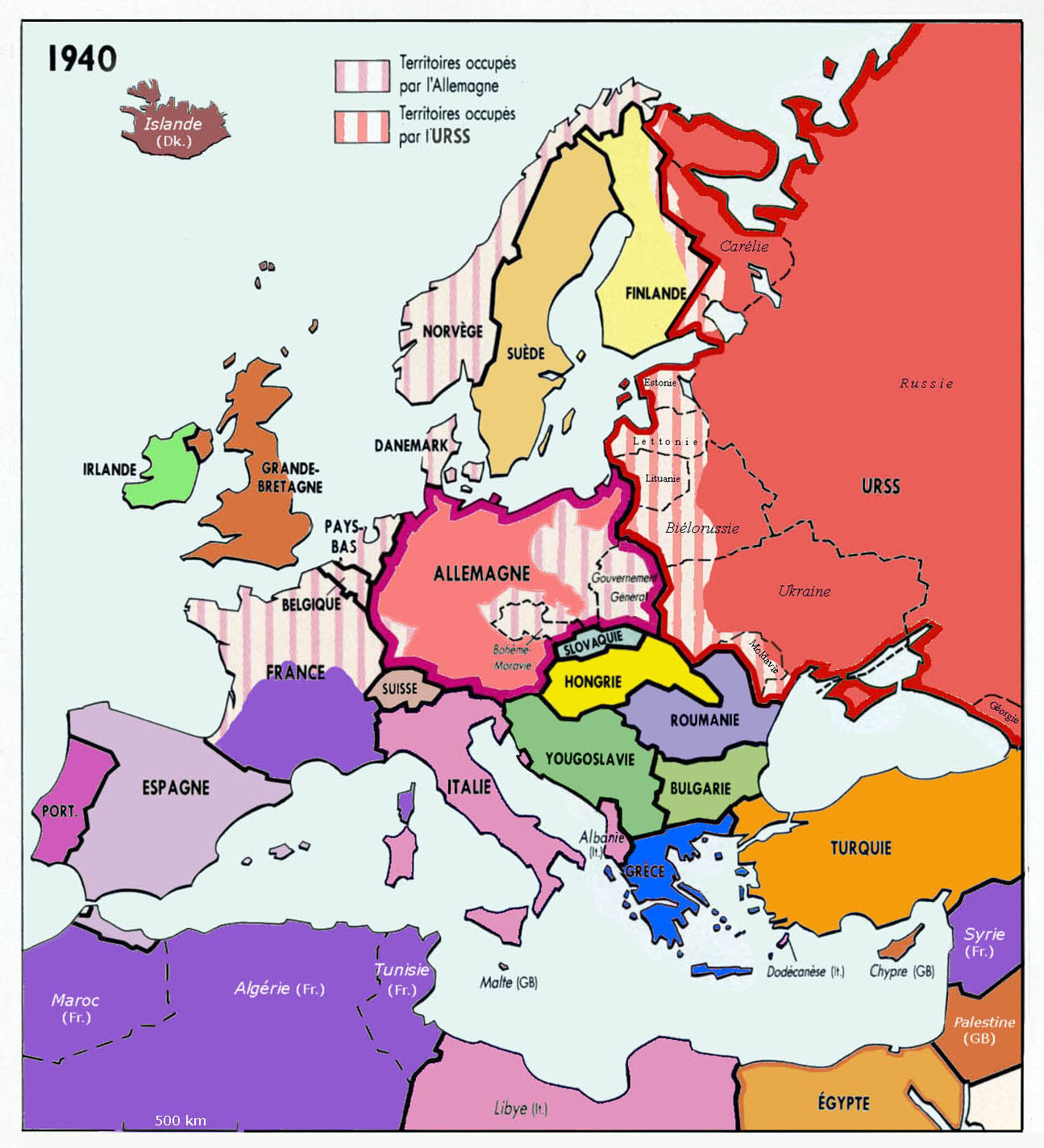
English: Historical map of Europe, year 1940, since Grosser Atlas zur Weltgeschichte, Westermann 1985,
ISBN
3-14-100919-8 & Anne Le Fur
Français : Carte historique de l'Europe en 1940, d'après Grosser Atlas zur Weltgeschichte, Westermann 1985,
ISBN
3-14-100919-8 et Anne Le Fur |
| Date | |
| Source | Own work |
| Author | Spiridon MANOLIU |
Licensing
I, the copyright holder of this work, hereby publish it under the following licenses:

|
Permission is granted to copy, distribute and/or modify this document under the terms of the GNU Free Documentation License, Version 1.2 or any later version published by the Free Software Foundation; with no Invariant Sections, no Front-Cover Texts, and no Back-Cover Texts. A copy of the license is included in the section entitled GNU Free Documentation License. |
This file is licensed under the
Creative Commons Attribution-Share Alike
3.0 Unported,
2.5 Generic,
2.0 Generic and
1.0 Generic license.
- You are free:
- to share – to copy, distribute and transmit the work
- to remix – to adapt the work
- Under the following conditions:
- attribution – You must give appropriate credit, provide a link to the license, and indicate if changes were made. You may do so in any reasonable manner, but not in any way that suggests the licensor endorses you or your use.
- share alike – If you remix, transform, or build upon the material, you must distribute your contributions under the same or compatible license as the original.
You may select the license of your choice.
File history
Click on a date/time to view the file as it appeared at that time.
| Date/Time | Thumbnail | Dimensions | User | Comment | |
|---|---|---|---|---|---|
| current | 14:51, 16 August 2018 |
| 1,295 × 1,424 (229 KB) | Trecătorul răcit | Cleaned |
| 17:23, 8 March 2009 |
 | 1,295 × 1,424 (232 KB) | Spiridon Ion Cepleanu | {{Information |Description={{en|1=Historical map of Europe, year 1940}} {{fr|1=Carte historique de l'Europe en 1940, d'après Anne Le Fur}} |Source=travail personnel (own work) |Author= Spiridon MANOLIU |Date=March 8, 2009 |Permis |
File usage
The following pages on the English Wikipedia use this file (pages on other projects are not listed):
Global file usage
The following other wikis use this file:
- Usage on fr.wikipedia.org
- Usage on gl.wikipedia.org
- Usage on pt.wikipedia.org
- Usage on uk.wikipedia.org
Metadata
Size of this preview:
545 × 599 pixels. Other resolutions:
218 × 240 pixels |
436 × 480 pixels |
698 × 768 pixels |
931 × 1,024 pixels |
1,295 × 1,424 pixels.
Original file (1,295 × 1,424 pixels, file size: 229 KB, MIME type: image/jpeg)
| This is a file from the
Wikimedia Commons. Information from its
description page there is shown below. Commons is a freely licensed media file repository. You can help. |
Summary
| Description |
English: Historical map of Europe, year 1940, since Grosser Atlas zur Weltgeschichte, Westermann 1985,
ISBN
3-14-100919-8 & Anne Le Fur
Français : Carte historique de l'Europe en 1940, d'après Grosser Atlas zur Weltgeschichte, Westermann 1985,
ISBN
3-14-100919-8 et Anne Le Fur |
| Date | |
| Source | Own work |
| Author | Spiridon MANOLIU |
Licensing
I, the copyright holder of this work, hereby publish it under the following licenses:
|
|
Permission is granted to copy, distribute and/or modify this document under the terms of the GNU Free Documentation License, Version 1.2 or any later version published by the Free Software Foundation; with no Invariant Sections, no Front-Cover Texts, and no Back-Cover Texts. A copy of the license is included in the section entitled GNU Free Documentation License. |
This file is licensed under the
Creative Commons Attribution-Share Alike
3.0 Unported,
2.5 Generic,
2.0 Generic and
1.0 Generic license.
- You are free:
- to share – to copy, distribute and transmit the work
- to remix – to adapt the work
- Under the following conditions:
- attribution – You must give appropriate credit, provide a link to the license, and indicate if changes were made. You may do so in any reasonable manner, but not in any way that suggests the licensor endorses you or your use.
- share alike – If you remix, transform, or build upon the material, you must distribute your contributions under the same or compatible license as the original.
You may select the license of your choice.
File history
Click on a date/time to view the file as it appeared at that time.
| Date/Time | Thumbnail | Dimensions | User | Comment | |
|---|---|---|---|---|---|
| current | 14:51, 16 August 2018 |
| 1,295 × 1,424 (229 KB) | Trecătorul răcit | Cleaned |
| 17:23, 8 March 2009 |
| 1,295 × 1,424 (232 KB) | Spiridon Ion Cepleanu | {{Information |Description={{en|1=Historical map of Europe, year 1940}} {{fr|1=Carte historique de l'Europe en 1940, d'après Anne Le Fur}} |Source=travail personnel (own work) |Author= Spiridon MANOLIU |Date=March 8, 2009 |Permis |
File usage
The following pages on the English Wikipedia use this file (pages on other projects are not listed):
Global file usage
The following other wikis use this file:
- Usage on fr.wikipedia.org
- Usage on gl.wikipedia.org
- Usage on pt.wikipedia.org
- Usage on uk.wikipedia.org