Photos • Location


Size of this preview:
800 × 533 pixels. Other resolutions:
320 × 213 pixels |
640 × 427 pixels |
1,024 × 682 pixels |
1,280 × 853 pixels |
2,590 × 1,726 pixels.
Original file (2,590 × 1,726 pixels, file size: 1.46 MB, MIME type: image/jpeg)
| This is a file from the
Wikimedia Commons. Information from its
description page there is shown below. Commons is a freely licensed media file repository. You can help. |
.jpg)
Summary
| Description |
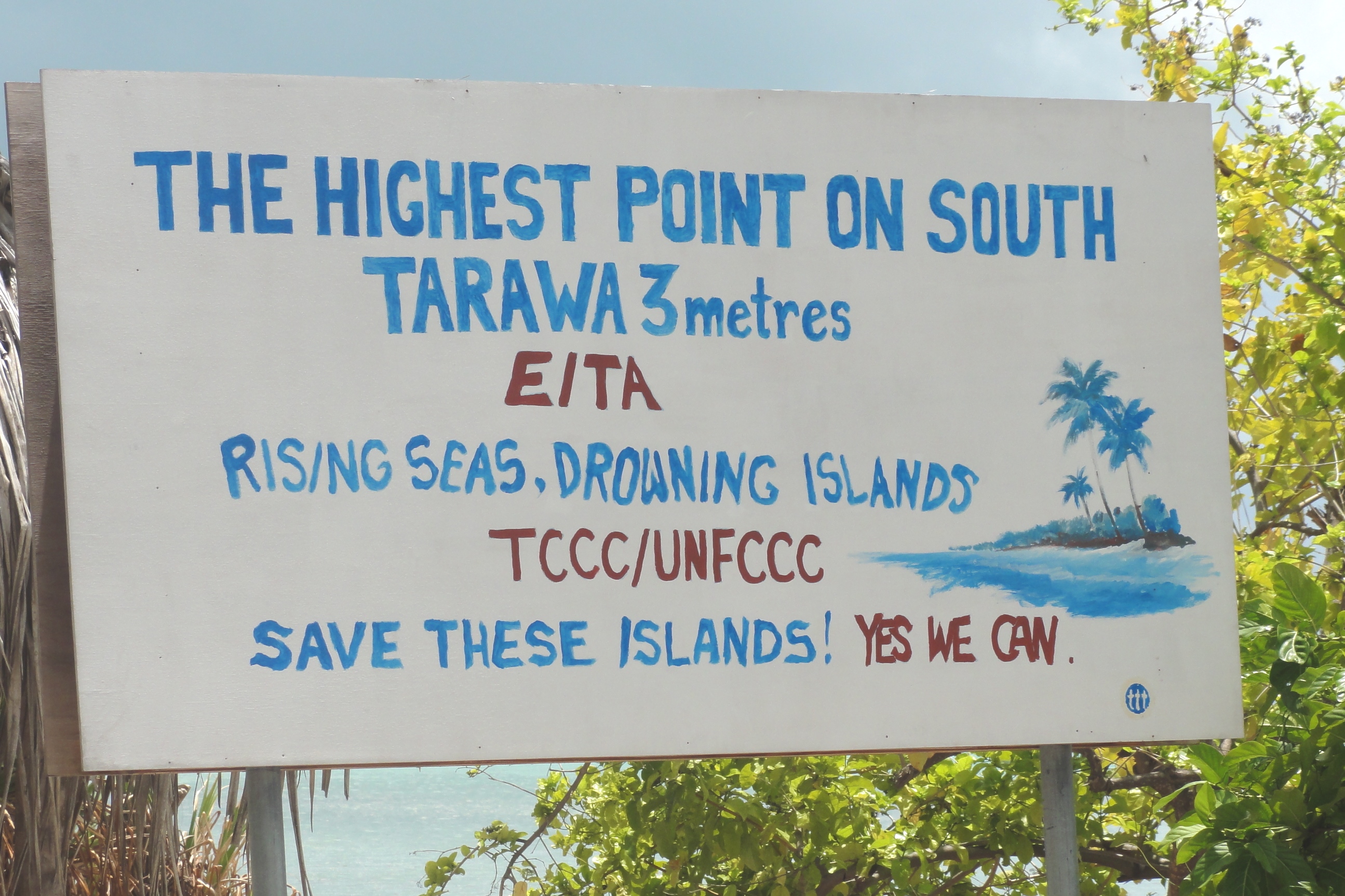
English: As an extremely low-lying country, surrounded by vast oceans, Kiribati is at risk from the negative effects of climate change, such as sea-level rise and storm surges, 2011. Photo: Erin Magee / DFAT. |
| Date | |
| Source | As an extremely low-lying country, surrounded by vast oceans, Kiribati is at risk from the negative effects of climate change, such as sea-level rise and storm surges, 2011. Photo: Erin Magee / DFAT |
| Author | Erin Magee/DFAT |
| Camera location | | View this and other nearby images on: OpenStreetMap |
|
|---|
.jpg¶ms=001.363616_N_0173.085516_E_globe:Earth_type:camera_alt:120.6_source:exif_heading:205.25&language=en)
Licensing
This file is licensed under the
Creative Commons
Attribution 2.0 Generic license.
Attribution: Erin Magee/DFAT
- You are free:
- to share – to copy, distribute and transmit the work
- to remix – to adapt the work
- Under the following conditions:
- attribution – You must give appropriate credit, provide a link to the license, and indicate if changes were made. You may do so in any reasonable manner, but not in any way that suggests the licensor endorses you or your use.
| This image was originally posted to Flickr by DFAT photo library at https://www.flickr.com/photos/106853342@N04/12426392094. It was reviewed on 14 April 2014 by FlickreviewR and was confirmed to be licensed under the terms of the cc-by-2.0. |
File history
Click on a date/time to view the file as it appeared at that time.
| Date/Time | Thumbnail | Dimensions | User | Comment | |
|---|---|---|---|---|---|
| current | 05:58, 14 April 2014 |
| 2,590 × 1,726 (1.46 MB) | Russavia | Transferred from Flickr via Flickr2commons |
File usage
The following pages on the English Wikipedia use this file (pages on other projects are not listed):
Global file usage
The following other wikis use this file:
- Usage on ig.wikipedia.org
- Usage on sv.wikipedia.org
- Usage on zh.wikipedia.org
Metadata
.jpg)
Size of this preview:
800 × 533 pixels. Other resolutions:
320 × 213 pixels |
640 × 427 pixels |
1,024 × 682 pixels |
1,280 × 853 pixels |
2,590 × 1,726 pixels.
Original file (2,590 × 1,726 pixels, file size: 1.46 MB, MIME type: image/jpeg)
| This is a file from the
Wikimedia Commons. Information from its
description page there is shown below. Commons is a freely licensed media file repository. You can help. |
Summary
| Description |
English: As an extremely low-lying country, surrounded by vast oceans, Kiribati is at risk from the negative effects of climate change, such as sea-level rise and storm surges, 2011. Photo: Erin Magee / DFAT. |
| Date | |
| Source | As an extremely low-lying country, surrounded by vast oceans, Kiribati is at risk from the negative effects of climate change, such as sea-level rise and storm surges, 2011. Photo: Erin Magee / DFAT |
| Author | Erin Magee/DFAT |
| Camera location | | View this and other nearby images on: OpenStreetMap |
|
|---|
Licensing
This file is licensed under the
Creative Commons
Attribution 2.0 Generic license.
Attribution: Erin Magee/DFAT
- You are free:
- to share – to copy, distribute and transmit the work
- to remix – to adapt the work
- Under the following conditions:
- attribution – You must give appropriate credit, provide a link to the license, and indicate if changes were made. You may do so in any reasonable manner, but not in any way that suggests the licensor endorses you or your use.
| This image was originally posted to Flickr by DFAT photo library at https://www.flickr.com/photos/106853342@N04/12426392094. It was reviewed on 14 April 2014 by FlickreviewR and was confirmed to be licensed under the terms of the cc-by-2.0. |
File history
Click on a date/time to view the file as it appeared at that time.
| Date/Time | Thumbnail | Dimensions | User | Comment | |
|---|---|---|---|---|---|
| current | 05:58, 14 April 2014 |
| 2,590 × 1,726 (1.46 MB) | Russavia | Transferred from Flickr via Flickr2commons |
File usage
The following pages on the English Wikipedia use this file (pages on other projects are not listed):
Global file usage
The following other wikis use this file:
- Usage on ig.wikipedia.org
- Usage on sv.wikipedia.org
- Usage on zh.wikipedia.org