
Size of this preview:
725 × 600 pixels. Other resolutions:
290 × 240 pixels |
581 × 480 pixels |
803 × 664 pixels.
Original file (803 × 664 pixels, file size: 664 KB, MIME type: image/png)
| This is a file from the
Wikimedia Commons. Information from its
description page there is shown below. Commons is a freely licensed media file repository. You can help. |
Summary
| Description |
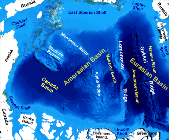
English: Main bathymetric features of the Arctic Ocean, taken mainly from Weber 1983 'Maps of the Arctic Basin Sea Floor: A History of Bathymetry and its Interpretation' on a base of a screenshot taken from the NASA WorldWind software |
| Date | |
| Source | Own work |
| Author | Mikenorton |
Licensing
I, the copyright holder of this work, hereby publish it under the following license:
This file is licensed under the
Creative Commons
Attribution-Share Alike 3.0 Unported license.
- You are free:
- to share – to copy, distribute and transmit the work
- to remix – to adapt the work
- Under the following conditions:
- attribution – You must give appropriate credit, provide a link to the license, and indicate if changes were made. You may do so in any reasonable manner, but not in any way that suggests the licensor endorses you or your use.
- share alike – If you remix, transform, or build upon the material, you must distribute your contributions under the same or compatible license as the original.
File history
Click on a date/time to view the file as it appeared at that time.
| Date/Time | Thumbnail | Dimensions | User | Comment | |
|---|---|---|---|---|---|
| current | 00:12, 10 November 2012 |
| 803 × 664 (664 KB) | Mikenorton | The 'Fram Basin' is now known as the 'Amundsen Basin' and the location of the two basins either side of the Gakkel Ridge has now been corrected |
| 11:21, 2 October 2011 |
 | 2,408 × 1,993 (1.42 MB) | Mikenorton |
File usage
The following pages on the English Wikipedia use this file (pages on other projects are not listed):
- Alpha Ridge
- Amerasia Basin
- Arctic Basin
- Arctic policy of Canada
- Canada Basin
- Chukchi Plateau
- Chukchi Shelf
- Eurasian Basin
- Gakkel Ridge
- Gakkel Ridge Caldera
- Litke Deep
- Lomonosov Ridge
- Makarov Basin
- Mendeleev Ridge
- Siberian Shelf
- Talk:Arctic policy of Canada
- Template:Did you know nominations/Geology of the Pacific Ocean
Global file usage
The following other wikis use this file:
- Usage on ar.wikipedia.org
- Usage on az.wikipedia.org
- Usage on be.wikipedia.org
- Usage on ca.wikipedia.org
- Usage on cs.wikipedia.org
- Usage on de.wikipedia.org
- Usage on en.wikiversity.org
- Usage on eo.wikipedia.org
- Usage on es.wikipedia.org
- Usage on fa.wikipedia.org
- Usage on fr.wikipedia.org
- Usage on hy.wikipedia.org
- Usage on it.wikipedia.org
View more global usage of this file.
Metadata
Size of this preview:
725 × 600 pixels. Other resolutions:
290 × 240 pixels |
581 × 480 pixels |
803 × 664 pixels.
Original file (803 × 664 pixels, file size: 664 KB, MIME type: image/png)
| This is a file from the
Wikimedia Commons. Information from its
description page there is shown below. Commons is a freely licensed media file repository. You can help. |
Summary
| Description |
English: Main bathymetric features of the Arctic Ocean, taken mainly from Weber 1983 'Maps of the Arctic Basin Sea Floor: A History of Bathymetry and its Interpretation' on a base of a screenshot taken from the NASA WorldWind software |
| Date | |
| Source | Own work |
| Author | Mikenorton |
Licensing
I, the copyright holder of this work, hereby publish it under the following license:
This file is licensed under the
Creative Commons
Attribution-Share Alike 3.0 Unported license.
- You are free:
- to share – to copy, distribute and transmit the work
- to remix – to adapt the work
- Under the following conditions:
- attribution – You must give appropriate credit, provide a link to the license, and indicate if changes were made. You may do so in any reasonable manner, but not in any way that suggests the licensor endorses you or your use.
- share alike – If you remix, transform, or build upon the material, you must distribute your contributions under the same or compatible license as the original.
File history
Click on a date/time to view the file as it appeared at that time.
| Date/Time | Thumbnail | Dimensions | User | Comment | |
|---|---|---|---|---|---|
| current | 00:12, 10 November 2012 |
| 803 × 664 (664 KB) | Mikenorton | The 'Fram Basin' is now known as the 'Amundsen Basin' and the location of the two basins either side of the Gakkel Ridge has now been corrected |
| 11:21, 2 October 2011 |
| 2,408 × 1,993 (1.42 MB) | Mikenorton |
File usage
The following pages on the English Wikipedia use this file (pages on other projects are not listed):
- Alpha Ridge
- Amerasia Basin
- Arctic Basin
- Arctic policy of Canada
- Canada Basin
- Chukchi Plateau
- Chukchi Shelf
- Eurasian Basin
- Gakkel Ridge
- Gakkel Ridge Caldera
- Litke Deep
- Lomonosov Ridge
- Makarov Basin
- Mendeleev Ridge
- Siberian Shelf
- Talk:Arctic policy of Canada
- Template:Did you know nominations/Geology of the Pacific Ocean
Global file usage
The following other wikis use this file:
- Usage on ar.wikipedia.org
- Usage on az.wikipedia.org
- Usage on be.wikipedia.org
- Usage on ca.wikipedia.org
- Usage on cs.wikipedia.org
- Usage on de.wikipedia.org
- Usage on en.wikiversity.org
- Usage on eo.wikipedia.org
- Usage on es.wikipedia.org
- Usage on fa.wikipedia.org
- Usage on fr.wikipedia.org
- Usage on hy.wikipedia.org
- Usage on it.wikipedia.org
View more global usage of this file.