
Original file (3,242 × 3,572 pixels, file size: 1.12 MB, MIME type: image/png)
| This is a file from the
Wikimedia Commons. Information from its
description page there is shown below. Commons is a freely licensed media file repository. You can help. |
Summary
| Description |
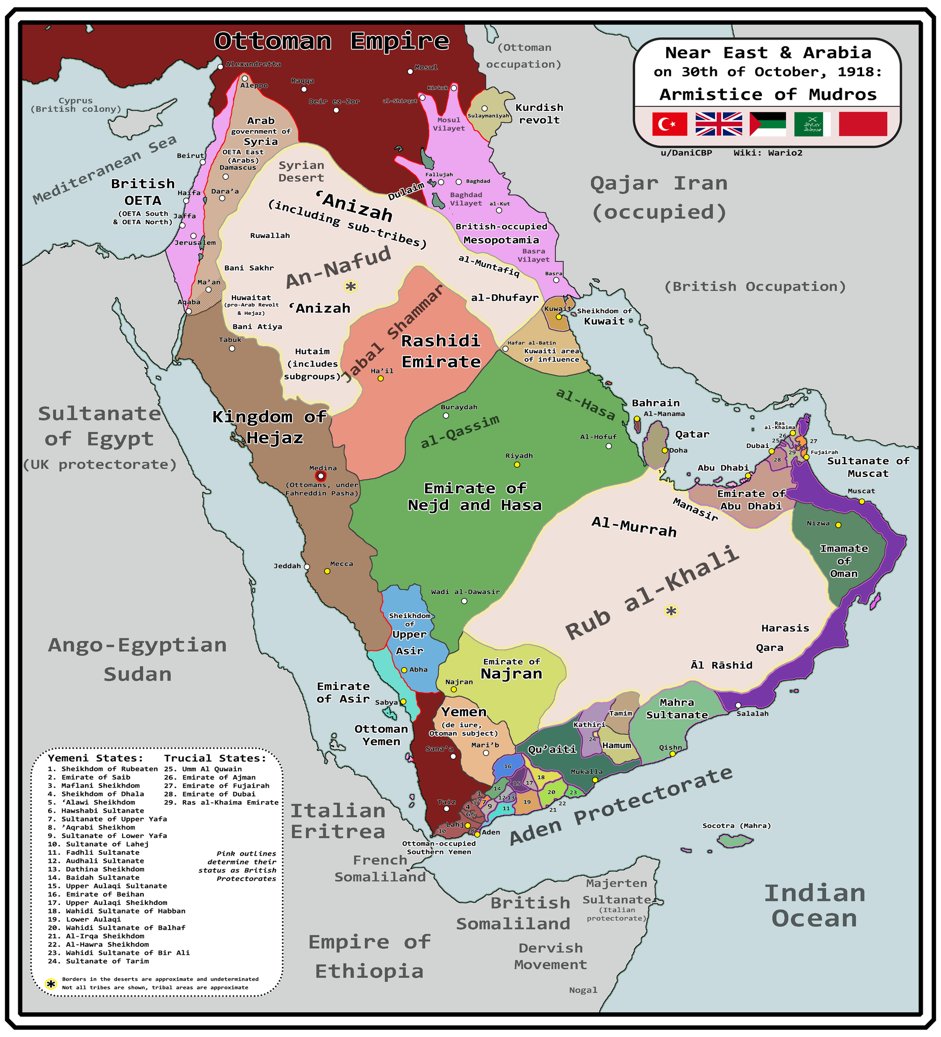
English: Map of Arabia and the Near East at the end of World War I, in October 30th, 1918, day of the Armistice of Mudros. |
| Date | |
| Source |
Own work + Ashkenazi, T. (1948). The ’Anazah Tribes. Southwestern Journal of Anthropology, 4(2), 222–239. http://www.jstor.org/stable/3628713 H. St. J. B. Philby. (1920). Southern Najd. The Geographical Journal, 55(3), 161–185. https://doi.org/10.2307/1781600 Haines, S. B. (1839). Memoir, to Accompany a Chart of the South Coast of Arabia from the Entrance of the Red Sea to Misenát, in 50° 43′ 25″ E. The Journal of the Royal Geographical Society of London, 9, 125–156. https://doi.org/10.2307/1797718 Helfritz, H. (1935). The First Crossing of Southwestern Arabia. Geographical Review, 25(3), 395–407. https://doi.org/10.2307/209308 Thomas, B. (1929). Among Some Unknown Tribes of South Arabia. The Journal of the Royal Anthropological Institute of Great Britain and Ireland, 59, 97–111. https://doi.org/10.2307/2843560 Anderson, S. (2014). Lawrence in Arabia: War, Deceit, Imperial Folly and the Making of the Modern Middle East. Atlantic Books Ltd. Boxberger, L. (2012). On the Edge of Empire: Hadhramawt, Emigration, and the Indian Ocean, 1880s–1930s. SUNY Press. J. E. Peterson. (1976) "The Revival of the Ibadi Imamate in Oman and the Threat to Muscat, 1913–20," Arabian Studies 3 Al-Maghafi, Fadhl (2012). "MORE THAN JUST A BOUNDARY DISPUTE: THE REGIONAL GEOPOLITICS OF SAUDI-YEMENI RELATIONS" (PDF). eprints.soas.ac.uk Bang, Anne (1997). The Idrisi State in Asir 1906–1934. Hurst Publishers. pp. 111–114. ISBN 9781850653066. Eskander, S. "Britain's Policy Towards The Kurdish Question, 1915-1923" (PDF). etheses.lse.ac.uk. |
| Author | Wario2 |
Licensing
- You are free:
- to share – to copy, distribute and transmit the work
- to remix – to adapt the work
- Under the following conditions:
- attribution – You must give appropriate credit, provide a link to the license, and indicate if changes were made. You may do so in any reasonable manner, but not in any way that suggests the licensor endorses you or your use.
File history
Click on a date/time to view the file as it appeared at that time.
| Date/Time | Thumbnail | Dimensions | User | Comment | |
|---|---|---|---|---|---|
| current | 10:18, 13 March 2024 |
| 3,242 × 3,572 (1.12 MB) | Wario2 | Uploaded own work with UploadWizard |
File usage
Global file usage
The following other wikis use this file:
- Usage on es.wikipedia.org
- Usage on mt.wikipedia.org
Metadata
Original file (3,242 × 3,572 pixels, file size: 1.12 MB, MIME type: image/png)
| This is a file from the
Wikimedia Commons. Information from its
description page there is shown below. Commons is a freely licensed media file repository. You can help. |
Summary
| Description |
English: Map of Arabia and the Near East at the end of World War I, in October 30th, 1918, day of the Armistice of Mudros. |
| Date | |
| Source |
Own work + Ashkenazi, T. (1948). The ’Anazah Tribes. Southwestern Journal of Anthropology, 4(2), 222–239. http://www.jstor.org/stable/3628713 H. St. J. B. Philby. (1920). Southern Najd. The Geographical Journal, 55(3), 161–185. https://doi.org/10.2307/1781600 Haines, S. B. (1839). Memoir, to Accompany a Chart of the South Coast of Arabia from the Entrance of the Red Sea to Misenát, in 50° 43′ 25″ E. The Journal of the Royal Geographical Society of London, 9, 125–156. https://doi.org/10.2307/1797718 Helfritz, H. (1935). The First Crossing of Southwestern Arabia. Geographical Review, 25(3), 395–407. https://doi.org/10.2307/209308 Thomas, B. (1929). Among Some Unknown Tribes of South Arabia. The Journal of the Royal Anthropological Institute of Great Britain and Ireland, 59, 97–111. https://doi.org/10.2307/2843560 Anderson, S. (2014). Lawrence in Arabia: War, Deceit, Imperial Folly and the Making of the Modern Middle East. Atlantic Books Ltd. Boxberger, L. (2012). On the Edge of Empire: Hadhramawt, Emigration, and the Indian Ocean, 1880s–1930s. SUNY Press. J. E. Peterson. (1976) "The Revival of the Ibadi Imamate in Oman and the Threat to Muscat, 1913–20," Arabian Studies 3 Al-Maghafi, Fadhl (2012). "MORE THAN JUST A BOUNDARY DISPUTE: THE REGIONAL GEOPOLITICS OF SAUDI-YEMENI RELATIONS" (PDF). eprints.soas.ac.uk Bang, Anne (1997). The Idrisi State in Asir 1906–1934. Hurst Publishers. pp. 111–114. ISBN 9781850653066. Eskander, S. "Britain's Policy Towards The Kurdish Question, 1915-1923" (PDF). etheses.lse.ac.uk. |
| Author | Wario2 |
Licensing
- You are free:
- to share – to copy, distribute and transmit the work
- to remix – to adapt the work
- Under the following conditions:
- attribution – You must give appropriate credit, provide a link to the license, and indicate if changes were made. You may do so in any reasonable manner, but not in any way that suggests the licensor endorses you or your use.
File history
Click on a date/time to view the file as it appeared at that time.
| Date/Time | Thumbnail | Dimensions | User | Comment | |
|---|---|---|---|---|---|
| current | 10:18, 13 March 2024 |
| 3,242 × 3,572 (1.12 MB) | Wario2 | Uploaded own work with UploadWizard |
File usage
Global file usage
The following other wikis use this file:
- Usage on es.wikipedia.org
- Usage on mt.wikipedia.org