Photos • Location


Size of this preview:
450 × 600 pixels. Other resolutions:
180 × 240 pixels |
360 × 480 pixels |
576 × 768 pixels |
768 × 1,024 pixels |
1,536 × 2,048 pixels |
3,864 × 5,152 pixels.
Original file (3,864 × 5,152 pixels, file size: 4.32 MB, MIME type: image/jpeg)
| This is a file from the
Wikimedia Commons. Information from its
description page there is shown below. Commons is a freely licensed media file repository. You can help. |
Summary
| Description |
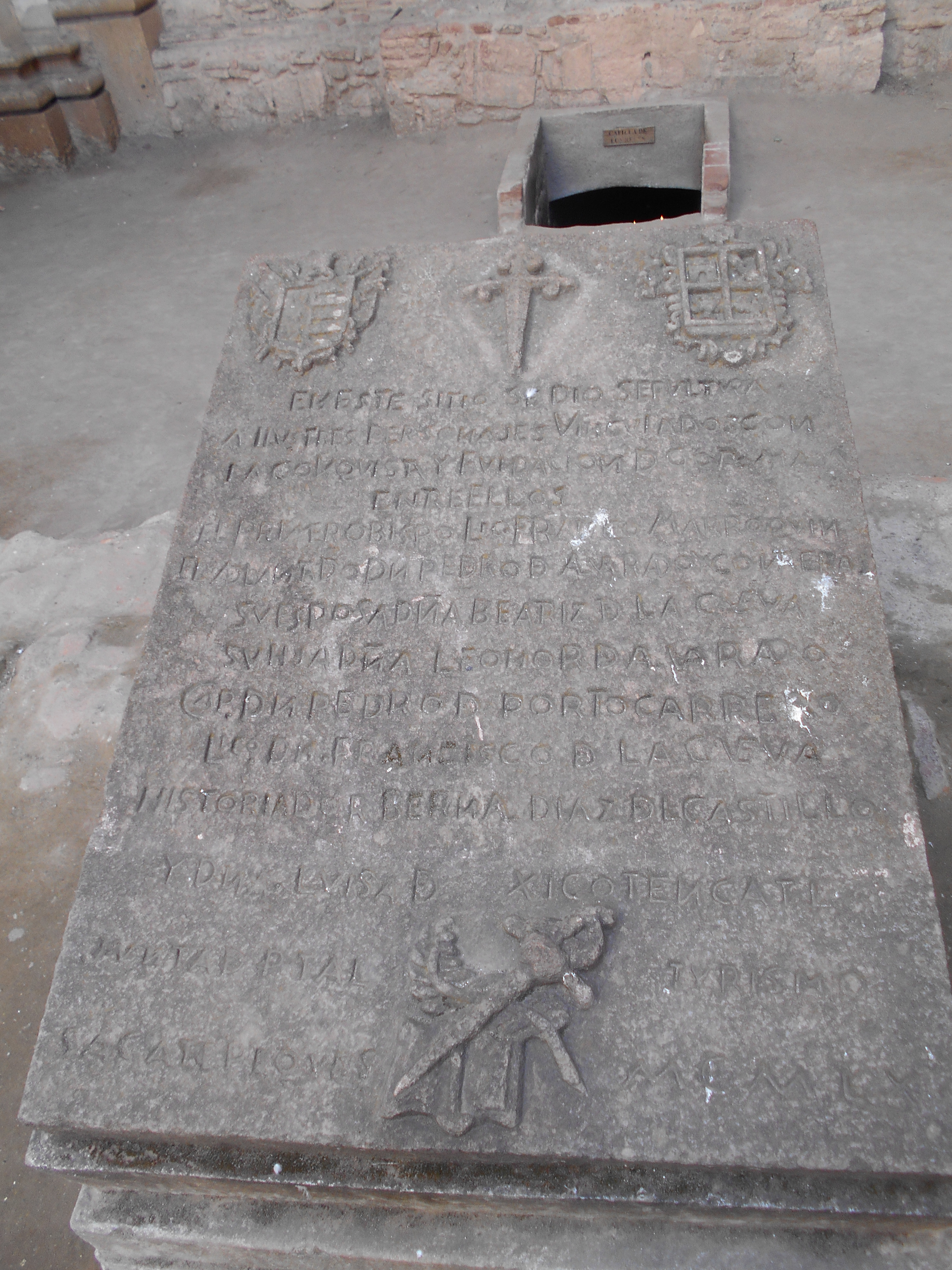
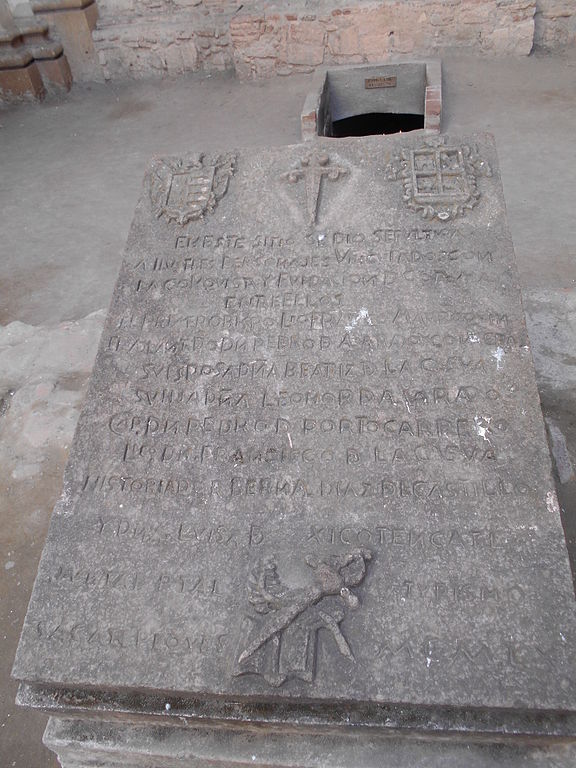
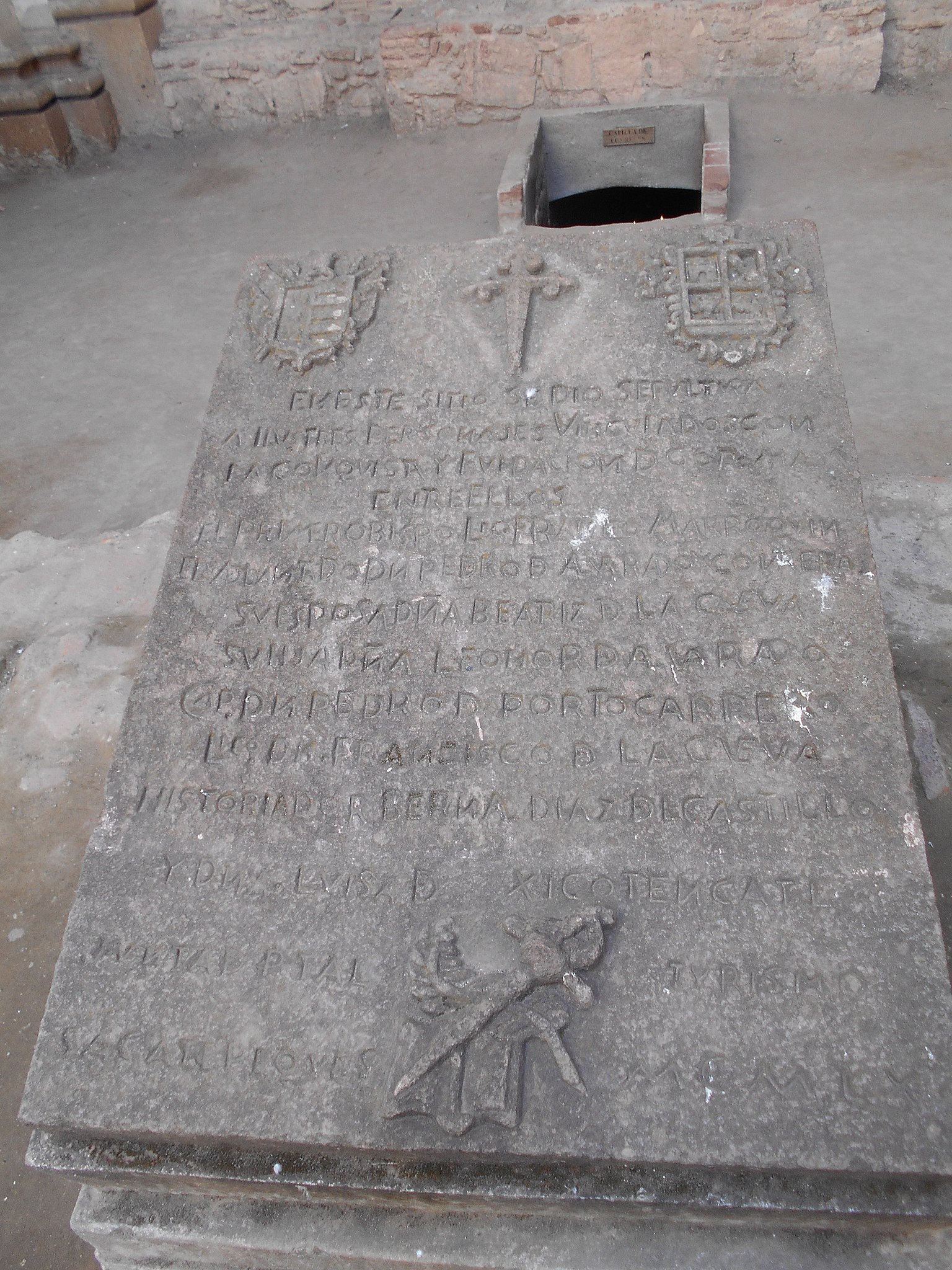
English: Ruins of the cathedral of Antigua Guatemala. Memorial stone place in 1960 to mark the tombs of Francisco Marroquín, first bishop of Guatemala, conquistador Pedro de Alvarado, his wife Beatriz de la Cueva, and daughter Leonor de Alvarado, conquistadors Pedro de Portocarrero, Francisco de la Cueva and Bernal Díaz del Castillo, and Luisa Xicoténcatl, Pedro de Alvarado's concubine.
Español: Ruinas de la catedral de Antigua Guatemala. "EN ESTE SITIO SE DIO SEPVLTVRA A ILVSTRES PERSONAJES VINCVLADOS CON LA CONQVISTA Y FVNDACION D GUATEMALA ENTRE ELLOS EL PRIMERO OBISPO LIC FRANCº MARROQVIN EL ADELANTADO DN PEDRO D ALVARADO CON EL A SU ESPOSA DÑA BEATRIZ D LA CVEVA SU HIJA DÑA LEONOR D ALVARADO CAP. DN PEDRO D PORTOCARRERO LICº DN FRANCISCO D LA CVEVA HISTORIADOR BERNAL DIAZ DL CASTILLO Y DÑA LVISA D XICOTENCATL [...] SACATEPEQUES TVRISMO MCMLX |
| Date | |
| Source | Own work |
| Author | Simon Burchell |
| Camera location |
| View this and other nearby images on: OpenStreetMap |
|
|---|
Licensing
I, the copyright holder of this work, hereby publish it under the following license:
This file is licensed under the
Creative Commons
Attribution-Share Alike 4.0 International license.
- You are free:
- to share – to copy, distribute and transmit the work
- to remix – to adapt the work
- Under the following conditions:
- attribution – You must give appropriate credit, provide a link to the license, and indicate if changes were made. You may do so in any reasonable manner, but not in any way that suggests the licensor endorses you or your use.
- share alike – If you remix, transform, or build upon the material, you must distribute your contributions under the same or compatible license as the original.
File history
Click on a date/time to view the file as it appeared at that time.
| Date/Time | Thumbnail | Dimensions | User | Comment | |
|---|---|---|---|---|---|
| current | 14:50, 7 March 2016 |
| 3,864 × 5,152 (4.32 MB) | Simon Burchell | User created page with UploadWizard |
File usage
The following pages on the English Wikipedia use this file (pages on other projects are not listed):
Global file usage
The following other wikis use this file:
- Usage on ru.wikipedia.org
Metadata
Size of this preview:
450 × 600 pixels. Other resolutions:
180 × 240 pixels |
360 × 480 pixels |
576 × 768 pixels |
768 × 1,024 pixels |
1,536 × 2,048 pixels |
3,864 × 5,152 pixels.
Original file (3,864 × 5,152 pixels, file size: 4.32 MB, MIME type: image/jpeg)
| This is a file from the
Wikimedia Commons. Information from its
description page there is shown below. Commons is a freely licensed media file repository. You can help. |
Summary
| Description |
English: Ruins of the cathedral of Antigua Guatemala. Memorial stone place in 1960 to mark the tombs of Francisco Marroquín, first bishop of Guatemala, conquistador Pedro de Alvarado, his wife Beatriz de la Cueva, and daughter Leonor de Alvarado, conquistadors Pedro de Portocarrero, Francisco de la Cueva and Bernal Díaz del Castillo, and Luisa Xicoténcatl, Pedro de Alvarado's concubine.
Español: Ruinas de la catedral de Antigua Guatemala. "EN ESTE SITIO SE DIO SEPVLTVRA A ILVSTRES PERSONAJES VINCVLADOS CON LA CONQVISTA Y FVNDACION D GUATEMALA ENTRE ELLOS EL PRIMERO OBISPO LIC FRANCº MARROQVIN EL ADELANTADO DN PEDRO D ALVARADO CON EL A SU ESPOSA DÑA BEATRIZ D LA CVEVA SU HIJA DÑA LEONOR D ALVARADO CAP. DN PEDRO D PORTOCARRERO LICº DN FRANCISCO D LA CVEVA HISTORIADOR BERNAL DIAZ DL CASTILLO Y DÑA LVISA D XICOTENCATL [...] SACATEPEQUES TVRISMO MCMLX |
| Date | |
| Source | Own work |
| Author | Simon Burchell |
| Camera location |
| View this and other nearby images on: OpenStreetMap |
|
|---|
Licensing
I, the copyright holder of this work, hereby publish it under the following license:
This file is licensed under the
Creative Commons
Attribution-Share Alike 4.0 International license.
- You are free:
- to share – to copy, distribute and transmit the work
- to remix – to adapt the work
- Under the following conditions:
- attribution – You must give appropriate credit, provide a link to the license, and indicate if changes were made. You may do so in any reasonable manner, but not in any way that suggests the licensor endorses you or your use.
- share alike – If you remix, transform, or build upon the material, you must distribute your contributions under the same or compatible license as the original.
File history
Click on a date/time to view the file as it appeared at that time.
| Date/Time | Thumbnail | Dimensions | User | Comment | |
|---|---|---|---|---|---|
| current | 14:50, 7 March 2016 |
| 3,864 × 5,152 (4.32 MB) | Simon Burchell | User created page with UploadWizard |
File usage
The following pages on the English Wikipedia use this file (pages on other projects are not listed):
Global file usage
The following other wikis use this file:
- Usage on ru.wikipedia.org