Size of this preview:
536 × 600 pixels. Other resolutions:
214 × 240 pixels |
429 × 480 pixels |
686 × 768 pixels |
915 × 1,024 pixels |
1,887 × 2,112 pixels.
Original file (1,887 × 2,112 pixels, file size: 732 KB, MIME type: image/png)
| This is a file from the
Wikimedia Commons. Information from its
description page there is shown below. Commons is a freely licensed media file repository. You can help. |
Summary
| Description |
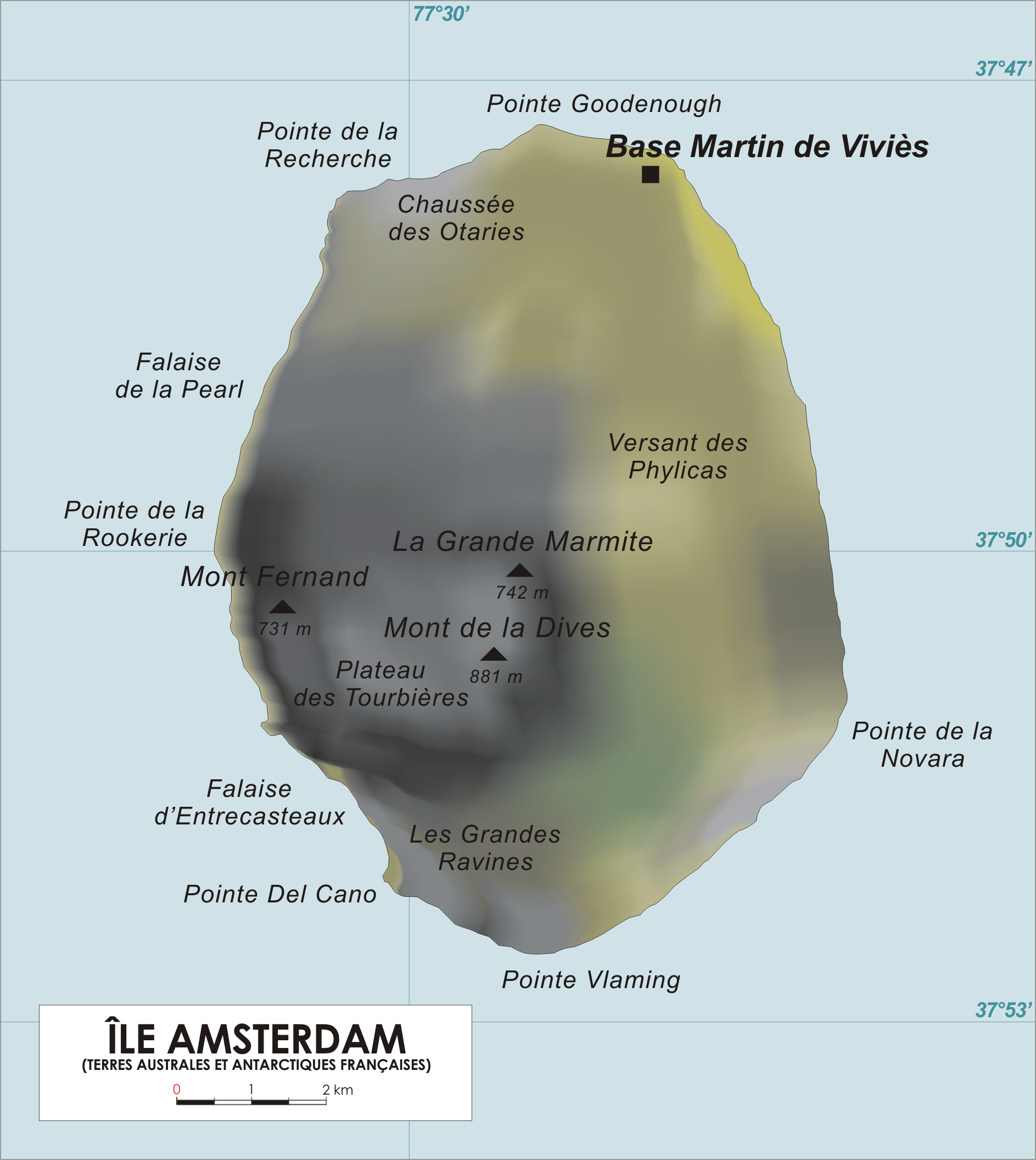
English: Map of Amsterdam Island, French Southern and Antarctic Territories.
Français : Carte de l'Ile Amsterdam, Terres australes et antarctiques françaises. |
| Date | |
| Source | Original drawing |
| Author | varp |
Licensing
| I, the copyright holder of this work, release this work into the
public domain. This applies worldwide. In some countries this may not be legally possible; if so: I grant anyone the right to use this work for any purpose, without any conditions, unless such conditions are required by law. |
File history
Click on a date/time to view the file as it appeared at that time.
| Date/Time | Thumbnail | Dimensions | User | Comment | |
|---|---|---|---|---|---|
| current | 17:43, 28 January 2013 |
| 1,887 × 2,112 (732 KB) | Olli Niemitalo | Correct scale bar length |
| 14:05, 27 April 2006 |
 | 1,887 × 2,112 (1.05 MB) | Varp~commonswiki | ||
| 13:50, 26 April 2006 |
 | 1,887 × 1,965 (1.01 MB) | Varp~commonswiki | *Map of Amsterdam Island, French Southern and Antarctic Territories *drawn by varp |
File usage
The following pages on the English Wikipedia use this file (pages on other projects are not listed):
Global file usage
The following other wikis use this file:
- Usage on af.wikipedia.org
- Usage on ar.wikipedia.org
- Usage on az.wikipedia.org
- Usage on bg.wikipedia.org
- Usage on br.wikipedia.org
- Usage on ca.wikipedia.org
- Usage on ceb.wikipedia.org
- Usage on cs.wikipedia.org
- Usage on cv.wikipedia.org
- Usage on da.wikipedia.org
- Usage on de.wikipedia.org
- Usage on el.wikipedia.org
- Usage on en.wikivoyage.org
- Usage on eo.wikipedia.org
- Usage on es.wikipedia.org
- Usage on fi.wikipedia.org
- Usage on fr.wikipedia.org
- Usage on fr.wiktionary.org
- Usage on fy.wikipedia.org
- Usage on gl.wikipedia.org
- Usage on hr.wikipedia.org
- Usage on hu.wikipedia.org
- Usage on id.wikipedia.org
- Usage on it.wikipedia.org
- Usage on ja.wikipedia.org
- Usage on ka.wikipedia.org
- Usage on ky.wikipedia.org
- Usage on lij.wikipedia.org
- Usage on lld.wikipedia.org
- Usage on lt.wikipedia.org
- Usage on lv.wikipedia.org
- Usage on mk.wikipedia.org
- Usage on nds-nl.wikipedia.org
- Usage on nds.wikipedia.org
View more global usage of this file.
Size of this preview:
536 × 600 pixels. Other resolutions:
214 × 240 pixels |
429 × 480 pixels |
686 × 768 pixels |
915 × 1,024 pixels |
1,887 × 2,112 pixels.
Original file (1,887 × 2,112 pixels, file size: 732 KB, MIME type: image/png)
| This is a file from the
Wikimedia Commons. Information from its
description page there is shown below. Commons is a freely licensed media file repository. You can help. |
Summary
| Description |
English: Map of Amsterdam Island, French Southern and Antarctic Territories.
Français : Carte de l'Ile Amsterdam, Terres australes et antarctiques françaises. |
| Date | |
| Source | Original drawing |
| Author | varp |
Licensing
| I, the copyright holder of this work, release this work into the
public domain. This applies worldwide. In some countries this may not be legally possible; if so: I grant anyone the right to use this work for any purpose, without any conditions, unless such conditions are required by law. |
File history
Click on a date/time to view the file as it appeared at that time.
| Date/Time | Thumbnail | Dimensions | User | Comment | |
|---|---|---|---|---|---|
| current | 17:43, 28 January 2013 |
| 1,887 × 2,112 (732 KB) | Olli Niemitalo | Correct scale bar length |
| 14:05, 27 April 2006 |
| 1,887 × 2,112 (1.05 MB) | Varp~commonswiki | ||
| 13:50, 26 April 2006 |
| 1,887 × 1,965 (1.01 MB) | Varp~commonswiki | *Map of Amsterdam Island, French Southern and Antarctic Territories *drawn by varp |
File usage
The following pages on the English Wikipedia use this file (pages on other projects are not listed):
Global file usage
The following other wikis use this file:
- Usage on af.wikipedia.org
- Usage on ar.wikipedia.org
- Usage on az.wikipedia.org
- Usage on bg.wikipedia.org
- Usage on br.wikipedia.org
- Usage on ca.wikipedia.org
- Usage on ceb.wikipedia.org
- Usage on cs.wikipedia.org
- Usage on cv.wikipedia.org
- Usage on da.wikipedia.org
- Usage on de.wikipedia.org
- Usage on el.wikipedia.org
- Usage on en.wikivoyage.org
- Usage on eo.wikipedia.org
- Usage on es.wikipedia.org
- Usage on fi.wikipedia.org
- Usage on fr.wikipedia.org
- Usage on fr.wiktionary.org
- Usage on fy.wikipedia.org
- Usage on gl.wikipedia.org
- Usage on hr.wikipedia.org
- Usage on hu.wikipedia.org
- Usage on id.wikipedia.org
- Usage on it.wikipedia.org
- Usage on ja.wikipedia.org
- Usage on ka.wikipedia.org
- Usage on ky.wikipedia.org
- Usage on lij.wikipedia.org
- Usage on lld.wikipedia.org
- Usage on lt.wikipedia.org
- Usage on lv.wikipedia.org
- Usage on mk.wikipedia.org
- Usage on nds-nl.wikipedia.org
- Usage on nds.wikipedia.org
View more global usage of this file.