
Original file (862 × 1,270 pixels, file size: 74 KB, MIME type: image/png)
| This is a file from the
Wikimedia Commons. Information from its
description page there is shown below. Commons is a freely licensed media file repository. You can help. |

|
This historical map image could be re-created using
vector graphics as an
SVG file. This has several advantages; see
Commons:Media for cleanup for more information. If an SVG form of this image is available, please upload it and afterwards replace this template with
{{
vector version available|new image name}}
.
It is recommended to name the SVG file “Americas independence map.svg”—then the template Vector version available (or Vva) does not need the new image name parameter. |
Summary
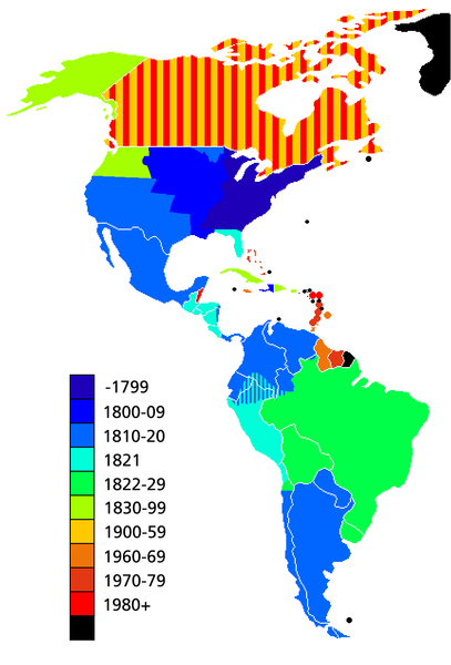
Map showing date of independence of country in the Americas. Black shows areas not yet independent.
Uses current boundaries, which may not correspond with the historical boundary of the country when it became independent. For example the United States was composed of 13 states on the East Coast when it became independent and did not reach its full continental extant until 1867 with the.
Licensing

|
Permission is granted to copy, distribute and/or modify this document under the terms of the GNU Free Documentation License, Version 1.2 or any later version published by the Free Software Foundation; with no Invariant Sections, no Front-Cover Texts, and no Back-Cover Texts. A copy of the license is included in the section entitled GNU Free Documentation License. |
| This file is licensed under the Creative Commons Attribution-Share Alike 3.0 Unported license. | ||
| ||
| This licensing tag was added to this file as part of the GFDL licensing update. |
File history
Click on a date/time to view the file as it appeared at that time.
| Date/Time | Thumbnail | Dimensions | User | Comment | |
|---|---|---|---|---|---|
| current | 14:23, 11 May 2019 |
| 862 × 1,270 (74 KB) | Foghe | Removed Labrador border; only current international borders. |
| 03:32, 25 April 2019 |
 | 862 × 1,270 (44 KB) | Marcomogollon | I add disputed territory between Colombia, Ecuador and Peru | |
| 23:11, 3 October 2011 |
 | 862 × 1,270 (68 KB) | Lemonade100 | Added some current dependent territories and re-coded Canada - gained sovereignty in 1939 and full independence in 1982. | |
| 18:35, 9 November 2010 |
 | 862 × 1,270 (38 KB) | Minnecologies | Fixed error in northern Canada | |
| 17:25, 9 November 2010 |
 | 862 × 1,270 (38 KB) | Minnecologies | *Filled in Pacific Northwest *Added Saint Pierre and Miquelon *Updated the boundaries of Gran Colombia, Bolivia, and Peru *Changed color scheme to straight ROYGBIV | |
| 06:32, 20 August 2007 |
 | 862 × 1,270 (61 KB) | AlexCovarrubias | Mexico independence year is 1810 | |
| 00:48, 7 December 2006 |
 | 862 × 1,270 (49 KB) | Roke~commonswiki | include colonies | |
| 12:48, 22 March 2006 |
 | 862 × 1,270 (63 KB) | Roke~commonswiki | Map showing date of independence of country in the Americas Category: America |
File usage
Global file usage
The following other wikis use this file:
- Usage on ar.wikipedia.org
- Usage on bg.wikipedia.org
- Usage on cs.wikipedia.org
- Usage on de.wikipedia.org
- Usage on es.wikipedia.org
- Usage on fa.wikipedia.org
- Usage on fi.wikipedia.org
- Usage on fr.wikipedia.org
- Usage on fy.wikipedia.org
- Usage on gl.wikipedia.org
- Usage on ja.wikipedia.org
- Usage on kn.wikipedia.org
- Usage on ms.wikipedia.org
- Usage on nds-nl.wikipedia.org
- Usage on nl.wikipedia.org
- Usage on no.wikipedia.org
- Usage on pt.wikipedia.org
- Usage on sd.wikinews.org
- Usage on uk.wikipedia.org
- Usage on www.wikidata.org
- Usage on wo.wikipedia.org
- Usage on zh.wikipedia.org
Metadata
Original file (862 × 1,270 pixels, file size: 74 KB, MIME type: image/png)
| This is a file from the
Wikimedia Commons. Information from its
description page there is shown below. Commons is a freely licensed media file repository. You can help. |
|
|
This historical map image could be re-created using
vector graphics as an
SVG file. This has several advantages; see
Commons:Media for cleanup for more information. If an SVG form of this image is available, please upload it and afterwards replace this template with
{{
vector version available|new image name}}
.
It is recommended to name the SVG file “Americas independence map.svg”—then the template Vector version available (or Vva) does not need the new image name parameter. |
Summary
Map showing date of independence of country in the Americas. Black shows areas not yet independent.
Uses current boundaries, which may not correspond with the historical boundary of the country when it became independent. For example the United States was composed of 13 states on the East Coast when it became independent and did not reach its full continental extant until 1867 with the.
Licensing
|
|
Permission is granted to copy, distribute and/or modify this document under the terms of the GNU Free Documentation License, Version 1.2 or any later version published by the Free Software Foundation; with no Invariant Sections, no Front-Cover Texts, and no Back-Cover Texts. A copy of the license is included in the section entitled GNU Free Documentation License. |
| This file is licensed under the Creative Commons Attribution-Share Alike 3.0 Unported license. | ||
| ||
| This licensing tag was added to this file as part of the GFDL licensing update. |
File history
Click on a date/time to view the file as it appeared at that time.
| Date/Time | Thumbnail | Dimensions | User | Comment | |
|---|---|---|---|---|---|
| current | 14:23, 11 May 2019 |
| 862 × 1,270 (74 KB) | Foghe | Removed Labrador border; only current international borders. |
| 03:32, 25 April 2019 |
| 862 × 1,270 (44 KB) | Marcomogollon | I add disputed territory between Colombia, Ecuador and Peru | |
| 23:11, 3 October 2011 |
| 862 × 1,270 (68 KB) | Lemonade100 | Added some current dependent territories and re-coded Canada - gained sovereignty in 1939 and full independence in 1982. | |
| 18:35, 9 November 2010 |
| 862 × 1,270 (38 KB) | Minnecologies | Fixed error in northern Canada | |
| 17:25, 9 November 2010 |
| 862 × 1,270 (38 KB) | Minnecologies | *Filled in Pacific Northwest *Added Saint Pierre and Miquelon *Updated the boundaries of Gran Colombia, Bolivia, and Peru *Changed color scheme to straight ROYGBIV | |
| 06:32, 20 August 2007 |
| 862 × 1,270 (61 KB) | AlexCovarrubias | Mexico independence year is 1810 | |
| 00:48, 7 December 2006 |
| 862 × 1,270 (49 KB) | Roke~commonswiki | include colonies | |
| 12:48, 22 March 2006 |
| 862 × 1,270 (63 KB) | Roke~commonswiki | Map showing date of independence of country in the Americas Category: America |
File usage
Global file usage
The following other wikis use this file:
- Usage on ar.wikipedia.org
- Usage on bg.wikipedia.org
- Usage on cs.wikipedia.org
- Usage on de.wikipedia.org
- Usage on es.wikipedia.org
- Usage on fa.wikipedia.org
- Usage on fi.wikipedia.org
- Usage on fr.wikipedia.org
- Usage on fy.wikipedia.org
- Usage on gl.wikipedia.org
- Usage on ja.wikipedia.org
- Usage on kn.wikipedia.org
- Usage on ms.wikipedia.org
- Usage on nds-nl.wikipedia.org
- Usage on nl.wikipedia.org
- Usage on no.wikipedia.org
- Usage on pt.wikipedia.org
- Usage on sd.wikinews.org
- Usage on uk.wikipedia.org
- Usage on www.wikidata.org
- Usage on wo.wikipedia.org
- Usage on zh.wikipedia.org