
Size of this PNG preview of this SVG file:
369 × 599 pixels. Other resolutions:
148 × 240 pixels |
295 × 480 pixels |
473 × 768 pixels |
630 × 1,024 pixels |
1,261 × 2,048 pixels |
945 × 1,535 pixels.
Original file (SVG file, nominally 945 × 1,535 pixels, file size: 889 KB)
| This is a file from the
Wikimedia Commons. Information from its
description page there is shown below. Commons is a freely licensed media file repository. You can help. |
Summary
| Description |
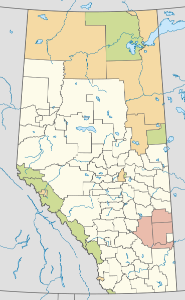
English: Map showing the classification of Alberta's rural municipalities.
Municipal boundary open data from AltaLIS, accessed on May 25 2019. Projection: EPSG:3401, transverse mercator, central meridian 115W Extents: -400000 W, 400000 E, 5400000 S, 6700000 N |
| Date | |
| Source | Own work |
| Author | awmcphee |
Licensing
I, the copyright holder of this work, hereby publish it under the following license:
| This file is made available under the Creative Commons CC0 1.0 Universal Public Domain Dedication. | |
| The person who associated a work with this deed has dedicated the work to the
public domain by waiving all of their rights to the work worldwide under copyright law, including all related and neighboring rights, to the extent allowed by law. You can copy, modify, distribute and perform the work, even for commercial purposes, all without asking permission.
|
File history
Click on a date/time to view the file as it appeared at that time.
| Date/Time | Thumbnail | Dimensions | User | Comment | |
|---|---|---|---|---|---|
| current | 20:23, 1 July 2019 |
| 945 × 1,535 (889 KB) | Awmcphee | User created page with UploadWizard |
File usage
The following pages on the English Wikipedia use this file (pages on other projects are not listed):
Global file usage
The following other wikis use this file:
- Usage on www.wikidata.org
Metadata
Size of this PNG preview of this SVG file:
369 × 599 pixels. Other resolutions:
148 × 240 pixels |
295 × 480 pixels |
473 × 768 pixels |
630 × 1,024 pixels |
1,261 × 2,048 pixels |
945 × 1,535 pixels.
Original file (SVG file, nominally 945 × 1,535 pixels, file size: 889 KB)
| This is a file from the
Wikimedia Commons. Information from its
description page there is shown below. Commons is a freely licensed media file repository. You can help. |
Summary
| Description |
English: Map showing the classification of Alberta's rural municipalities.
Municipal boundary open data from AltaLIS, accessed on May 25 2019. Projection: EPSG:3401, transverse mercator, central meridian 115W Extents: -400000 W, 400000 E, 5400000 S, 6700000 N |
| Date | |
| Source | Own work |
| Author | awmcphee |
Licensing
I, the copyright holder of this work, hereby publish it under the following license:
| This file is made available under the Creative Commons CC0 1.0 Universal Public Domain Dedication. | |
| The person who associated a work with this deed has dedicated the work to the
public domain by waiving all of their rights to the work worldwide under copyright law, including all related and neighboring rights, to the extent allowed by law. You can copy, modify, distribute and perform the work, even for commercial purposes, all without asking permission.
|
File history
Click on a date/time to view the file as it appeared at that time.
| Date/Time | Thumbnail | Dimensions | User | Comment | |
|---|---|---|---|---|---|
| current | 20:23, 1 July 2019 |
| 945 × 1,535 (889 KB) | Awmcphee | User created page with UploadWizard |
File usage
The following pages on the English Wikipedia use this file (pages on other projects are not listed):
Global file usage
The following other wikis use this file:
- Usage on www.wikidata.org