Size of this preview:
800 × 489 pixels. Other resolutions:
320 × 196 pixels |
640 × 391 pixels |
1,024 × 626 pixels |
1,280 × 782 pixels |
1,800 × 1,100 pixels.
Original file (1,800 × 1,100 pixels, file size: 1.57 MB, MIME type: image/jpeg)
| This is a file from the
Wikimedia Commons. Information from its
description page there is shown below. Commons is a freely licensed media file repository. You can help. |
Summary
| Description |
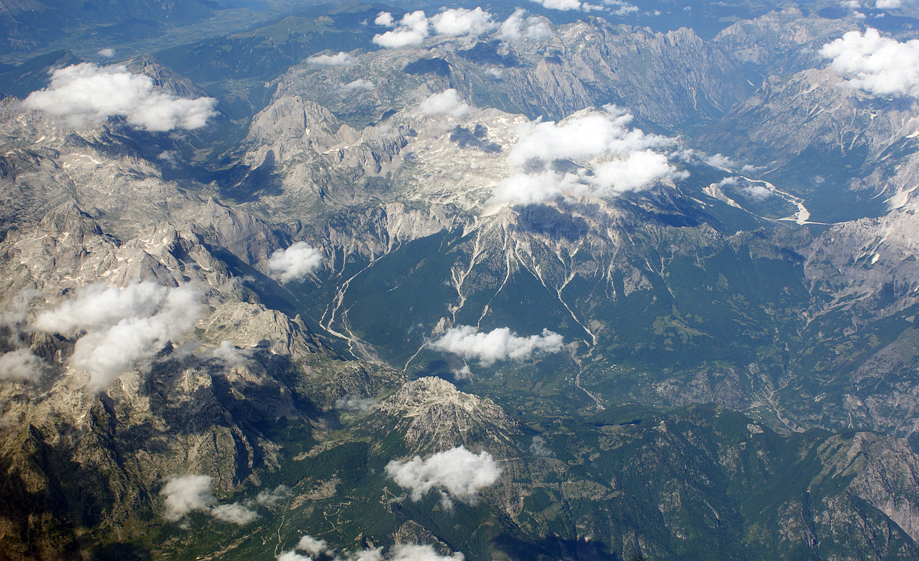
English: Albanian Alps seen from the air looking East. In the center the valley and the village of Theth. In the upper part on the right the Valbona valley with Maja Roshit and Kollata to the left. Between the two valleys are the Valbona pass (Qafa e Valbonës) and the Jezerca massif with the Jezerca peak between two clouds. To the left is the Peja pass (Qafa e Pejës) and the pyramid of Maja Arapit. Behind in the upper left corner the Montenegrinian Ropojana valley and the valley of Plav with parts of Lake Plav. To the left is the Radohima massif. In the lower part can be seen the road to Theth over Terthorja pass (Qafa Terthorjës). |
| Date | Summer 2009 |
| Source | Own work |
| Author | Albinfo |
Licensing
I, the copyright holder of this work, hereby publish it under the following licenses:

|
Permission is granted to copy, distribute and/or modify this document under the terms of the GNU Free Documentation License, Version 1.2 or any later version published by the Free Software Foundation; with no Invariant Sections, no Front-Cover Texts, and no Back-Cover Texts. A copy of the license is included in the section entitled GNU Free Documentation License. |
This file is licensed under the
Creative Commons Attribution-Share Alike
3.0 Unported,
2.5 Generic,
2.0 Generic and
1.0 Generic license.
- You are free:
- to share – to copy, distribute and transmit the work
- to remix – to adapt the work
- Under the following conditions:
- attribution – You must give appropriate credit, provide a link to the license, and indicate if changes were made. You may do so in any reasonable manner, but not in any way that suggests the licensor endorses you or your use.
- share alike – If you remix, transform, or build upon the material, you must distribute your contributions under the same or compatible license as the original.
You may select the license of your choice.
| Annotations | This image is annotated: View the annotations at Commons |
File history
Click on a date/time to view the file as it appeared at that time.
| Date/Time | Thumbnail | Dimensions | User | Comment | |
|---|---|---|---|---|---|
| current | 20:29, 5 August 2009 |
| 1,800 × 1,100 (1.57 MB) | Albinfo | {{Information |Description={{en|1=Albanian Alps seen from the air looking East. In the center the valley and the village of Theth. In the upper part on the right the Valbona valley with Maja Roshit and Kollata to the left. Between the two valleys are the |
File usage
The following pages on the English Wikipedia use this file (pages on other projects are not listed):
Global file usage
The following other wikis use this file:
- Usage on da.wikipedia.org
- Usage on de.wikipedia.org
- Usage on hy.wikipedia.org
- Usage on mk.wikipedia.org
- Usage on no.wikipedia.org
- Usage on ro.wikipedia.org
- Usage on sl.wikipedia.org
- Usage on sq.wikipedia.org
- Usage on sv.wikipedia.org
- Usage on uk.wikipedia.org
- Usage on vi.wikipedia.org
Metadata
Size of this preview:
800 × 489 pixels. Other resolutions:
320 × 196 pixels |
640 × 391 pixels |
1,024 × 626 pixels |
1,280 × 782 pixels |
1,800 × 1,100 pixels.
Original file (1,800 × 1,100 pixels, file size: 1.57 MB, MIME type: image/jpeg)
| This is a file from the
Wikimedia Commons. Information from its
description page there is shown below. Commons is a freely licensed media file repository. You can help. |
Summary
| Description |
English: Albanian Alps seen from the air looking East. In the center the valley and the village of Theth. In the upper part on the right the Valbona valley with Maja Roshit and Kollata to the left. Between the two valleys are the Valbona pass (Qafa e Valbonës) and the Jezerca massif with the Jezerca peak between two clouds. To the left is the Peja pass (Qafa e Pejës) and the pyramid of Maja Arapit. Behind in the upper left corner the Montenegrinian Ropojana valley and the valley of Plav with parts of Lake Plav. To the left is the Radohima massif. In the lower part can be seen the road to Theth over Terthorja pass (Qafa Terthorjës). |
| Date | Summer 2009 |
| Source | Own work |
| Author | Albinfo |
Licensing
I, the copyright holder of this work, hereby publish it under the following licenses:
|
|
Permission is granted to copy, distribute and/or modify this document under the terms of the GNU Free Documentation License, Version 1.2 or any later version published by the Free Software Foundation; with no Invariant Sections, no Front-Cover Texts, and no Back-Cover Texts. A copy of the license is included in the section entitled GNU Free Documentation License. |
This file is licensed under the
Creative Commons Attribution-Share Alike
3.0 Unported,
2.5 Generic,
2.0 Generic and
1.0 Generic license.
- You are free:
- to share – to copy, distribute and transmit the work
- to remix – to adapt the work
- Under the following conditions:
- attribution – You must give appropriate credit, provide a link to the license, and indicate if changes were made. You may do so in any reasonable manner, but not in any way that suggests the licensor endorses you or your use.
- share alike – If you remix, transform, or build upon the material, you must distribute your contributions under the same or compatible license as the original.
You may select the license of your choice.
| Annotations | This image is annotated: View the annotations at Commons |
File history
Click on a date/time to view the file as it appeared at that time.
| Date/Time | Thumbnail | Dimensions | User | Comment | |
|---|---|---|---|---|---|
| current | 20:29, 5 August 2009 |
| 1,800 × 1,100 (1.57 MB) | Albinfo | {{Information |Description={{en|1=Albanian Alps seen from the air looking East. In the center the valley and the village of Theth. In the upper part on the right the Valbona valley with Maja Roshit and Kollata to the left. Between the two valleys are the |
File usage
The following pages on the English Wikipedia use this file (pages on other projects are not listed):
Global file usage
The following other wikis use this file:
- Usage on da.wikipedia.org
- Usage on de.wikipedia.org
- Usage on hy.wikipedia.org
- Usage on mk.wikipedia.org
- Usage on no.wikipedia.org
- Usage on ro.wikipedia.org
- Usage on sl.wikipedia.org
- Usage on sq.wikipedia.org
- Usage on sv.wikipedia.org
- Usage on uk.wikipedia.org
- Usage on vi.wikipedia.org