
Size of this PNG preview of this SVG file:
555 × 352 pixels. Other resolutions:
320 × 203 pixels |
640 × 406 pixels |
1,024 × 649 pixels |
1,280 × 812 pixels |
2,560 × 1,624 pixels.
Original file (SVG file, nominally 555 × 352 pixels, file size: 1.74 MB)
| This is a file from the
Wikimedia Commons. Information from its
description page there is shown below. Commons is a freely licensed media file repository. You can help. |
| Description |
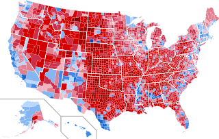
English: Results by county of the
United States presidential election, 2016.
Clinton—80-90%
Clinton—70-80%
Clinton—60-70%
Clinton—50-60%
Clinton—40-50%
Clinton—<40%
Trump—<40%
Trump—40-50%
Trump—50-60%
Trump—60-70%
Trump—70-80%
Trump—80-90%
Trump—>90%
|
||||
| Date | |||||
| Source |
This file was derived from:
USA Counties.svg |
||||
| Author | Ali Zifan and Inqvisitor | ||||
| Permission ( Reusing this file) |
|
||||
| Other versions |
|


.svg)
.svg)


File history
Click on a date/time to view the file as it appeared at that time.
| Date/Time | Thumbnail | Dimensions | User | Comment | |
|---|---|---|---|---|---|
| current | 23:04, 3 March 2023 |
| 555 × 352 (1.74 MB) | Gordfather69 | line width |
| 05:37, 1 December 2019 |
 | 555 × 352 (1.73 MB) | SpeedMcCool | Fixed Tazewell County, Illinois | |
| 16:06, 21 November 2019 |
 | 555 × 352 (1.73 MB) | SpeedMcCool | Updated McCone County Montana | |
| 01:13, 11 October 2019 |
 | 555 × 352 (1.73 MB) | SpeedMcCool | Fixed Potter and Lehigh Counties PA | |
| 21:50, 27 October 2018 |
 | 555 × 352 (1.73 MB) | Vartemp | Fixed shading for McDonald County, MO. | |
| 16:16, 29 July 2017 |
 | 555 × 352 (1.73 MB) | Inqvisitor | Two county shading corrections | |
| 16:41, 15 February 2017 |
 | 555 × 352 (1.74 MB) | Jayjay8990 | Reverted to version as of 05:49, 8 February 2017 (UTC) | |
| 01:50, 15 February 2017 |
 | 990 × 627 (983 KB) | Kingofthedead | Reverted to version as of 05:41, 8 February 2017 (UTC) I disagree that the borders are too thin, and this map is much larger and clearer | |
| 05:49, 8 February 2017 |
 | 555 × 352 (1.74 MB) | TL565 | Don't you falsely accuse me of sock puppetry! The map should match the previous county maps and yes the borders are way too thin. | |
| 05:41, 8 February 2017 |
 | 990 × 627 (983 KB) | Oganesson007 | @TL565 Please stop reverting the map with the alternative accounts. Also, This map is half of the size of that with optimal border size and more clarification. In this map (unlike the map that you keep putting here) small counties are clearly visible. |
File usage
The following pages on the English Wikipedia use this file (pages on other projects are not listed):
Global file usage
The following other wikis use this file:
- Usage on ar.wikipedia.org
- Usage on bg.wikipedia.org
- Usage on ca.wikipedia.org
- Usage on cs.wikipedia.org
- Usage on de.wikipedia.org
- Usage on fa.wikipedia.org
- Usage on fr.wikipedia.org
- Usage on hu.wikipedia.org
- Usage on nl.wikipedia.org
- Usage on no.wikipedia.org
- Usage on pa.wikipedia.org
- Usage on zh.wikipedia.org
Metadata
Size of this PNG preview of this SVG file:
555 × 352 pixels. Other resolutions:
320 × 203 pixels |
640 × 406 pixels |
1,024 × 649 pixels |
1,280 × 812 pixels |
2,560 × 1,624 pixels.
Original file (SVG file, nominally 555 × 352 pixels, file size: 1.74 MB)
| This is a file from the
Wikimedia Commons. Information from its
description page there is shown below. Commons is a freely licensed media file repository. You can help. |
| Description |
English: Results by county of the
United States presidential election, 2016.
Clinton—80-90%
Clinton—70-80%
Clinton—60-70%
Clinton—50-60%
Clinton—40-50%
Clinton—<40%
Trump—<40%
Trump—40-50%
Trump—50-60%
Trump—60-70%
Trump—70-80%
Trump—80-90%
Trump—>90%
|
||||
| Date | |||||
| Source |
This file was derived from:
USA Counties.svg |
||||
| Author | Ali Zifan and Inqvisitor | ||||
| Permission ( Reusing this file) |
|
||||
| Other versions |
|
File history
Click on a date/time to view the file as it appeared at that time.
| Date/Time | Thumbnail | Dimensions | User | Comment | |
|---|---|---|---|---|---|
| current | 23:04, 3 March 2023 |
| 555 × 352 (1.74 MB) | Gordfather69 | line width |
| 05:37, 1 December 2019 |
| 555 × 352 (1.73 MB) | SpeedMcCool | Fixed Tazewell County, Illinois | |
| 16:06, 21 November 2019 |
| 555 × 352 (1.73 MB) | SpeedMcCool | Updated McCone County Montana | |
| 01:13, 11 October 2019 |
| 555 × 352 (1.73 MB) | SpeedMcCool | Fixed Potter and Lehigh Counties PA | |
| 21:50, 27 October 2018 |
| 555 × 352 (1.73 MB) | Vartemp | Fixed shading for McDonald County, MO. | |
| 16:16, 29 July 2017 |
| 555 × 352 (1.73 MB) | Inqvisitor | Two county shading corrections | |
| 16:41, 15 February 2017 |
| 555 × 352 (1.74 MB) | Jayjay8990 | Reverted to version as of 05:49, 8 February 2017 (UTC) | |
| 01:50, 15 February 2017 |
| 990 × 627 (983 KB) | Kingofthedead | Reverted to version as of 05:41, 8 February 2017 (UTC) I disagree that the borders are too thin, and this map is much larger and clearer | |
| 05:49, 8 February 2017 |
| 555 × 352 (1.74 MB) | TL565 | Don't you falsely accuse me of sock puppetry! The map should match the previous county maps and yes the borders are way too thin. | |
| 05:41, 8 February 2017 |
| 990 × 627 (983 KB) | Oganesson007 | @TL565 Please stop reverting the map with the alternative accounts. Also, This map is half of the size of that with optimal border size and more clarification. In this map (unlike the map that you keep putting here) small counties are clearly visible. |
File usage
The following pages on the English Wikipedia use this file (pages on other projects are not listed):
Global file usage
The following other wikis use this file:
- Usage on ar.wikipedia.org
- Usage on bg.wikipedia.org
- Usage on ca.wikipedia.org
- Usage on cs.wikipedia.org
- Usage on de.wikipedia.org
- Usage on fa.wikipedia.org
- Usage on fr.wikipedia.org
- Usage on hu.wikipedia.org
- Usage on nl.wikipedia.org
- Usage on no.wikipedia.org
- Usage on pa.wikipedia.org
- Usage on zh.wikipedia.org