This is a file from the Wikimedia Commons
From Wikipedia, the free encyclopedia

Original file(596 × 676 pixels, file size: 16 KB, MIME type: image/png)


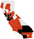
Description An image representing the 2009 swine flu outbreak in California
Date
Source I made this image myself using Fireworks MX 2004 and a locater map by Ruhrfisch ( talk · contribs) which can be found here.
Author ZabMilenko
Permission
( Reusing this file)
w:en:Creative Commons
attribution
This file is licensed under the Creative Commons Attribution 3.0 Unported license.
You are free:
  • to share – to copy, distribute and transmit the work
  • to remix – to adapt the work
Under the following conditions:
  • attribution – You must give appropriate credit, provide a link to the license, and indicate if changes were made. You may do so in any reasonable manner, but not in any way that suggests the licensor endorses you or your use.
Other versions file:California_Locator_Map.PNG
File:H1N1 California Map.svg is a vector version of this file. It should be used in place of this PNG file when not inferior.

File:2009 swine flu outbreak in California.png → File:H1N1 California Map.svg

For more information, see Help:SVG.

In other languages
Alemannisch  Bahasa Indonesia  Bahasa Melayu  British English  català  čeština  dansk  Deutsch  eesti  English  español  Esperanto  euskara  français  Frysk  galego  hrvatski  Ido  italiano  lietuvių  magyar  Nederlands  norsk bokmål  norsk nynorsk  occitan  Plattdüütsch  polski  português  português do Brasil  română  Scots  sicilianu  slovenčina  slovenščina  suomi  svenska  Tiếng Việt  Türkçe  vèneto  Ελληνικά  беларуская (тарашкевіца)  български  македонски  нохчийн  русский  српски / srpski  татарча/tatarça  українська  ქართული  հայերեն  বাংলা  தமிழ்  മലയാളം  ไทย  한국어  日本語  简体中文  繁體中文  עברית  العربية  فارسی  +/−
New SVG image

References

The following counties are highlighted:

RED: Alameda, Amador, Butte, Calaveras, Contra Costa, El Dorado, Imperial, Kings, Los Angeles, Madera, Marin, Monterey, Orange, Placer, Riverside, Sacramento, San Benito, San Bernardino, San Diego, San Francisco, San Joaquin, San Luis Obispo, San Mateo, Santa Clara, Shasta, Sonoma, Sutter, Tehama, Tulare, Ventura

YELLOW (and not red): Santa Barbara, Santa Cruz, Solano, Stanislaus, Yolo

Remaining:' Alpine, Colusa, Del Norte, Fresno, Glenn, Humboldt, Inyo, Kern, Lake, Lassen, Mariposa, Mendocino, Merced, Modoc, Mono, Napa, Nevada, Plumas, Sierra, Siskiyou, Trinity, Tuolumne, Yuba.

Information

Captions

Add a one-line explanation of what this file represents

Items portrayed in this file

depicts

8 May 2009

image/png

0e6f5dda8dc3beaa5e7a9ff955186bb40eaf4d3d

16,616 byte

676 pixel

596 pixel

File history

Click on a date/time to view the file as it appeared at that time.

Date/TimeThumbnailDimensionsUserComment
current 09:36, 29 May 2009 Thumbnail for version as of 09:36, 29 May 2009596 × 676 (16 KB)ZabMilenkoUpdates. Moved a couple suspected to confirmed but no new counties.
21:00, 22 May 2009 Thumbnail for version as of 21:00, 22 May 2009596 × 676 (16 KB)ZabMilenkoUpdates
06:56, 21 May 2009 Thumbnail for version as of 06:56, 21 May 2009596 × 676 (16 KB)ZabMilenkoColoring in the islands near the southern counties and a couple minor touchups around Lake Tahoe and the San Francisco Bay. ~~~~
06:18, 21 May 2009 Thumbnail for version as of 06:18, 21 May 2009596 × 676 (16 KB)ZabMilenkoChanges per [http://ww2.cdph.ca.gov/Pages/default.aspx this website]. ~~~~
04:50, 9 May 2009 Thumbnail for version as of 04:50, 9 May 2009596 × 676 (16 KB)ZabMilenko{{Information |Description=An image representing the 2009 swine flu outbreak in California |Source=I made this image myself using Fireworks MX 2004 and a locater map by {{user|Ruhrfisch}} which can be found here. |Date

Global file usage

The following other wikis use this file:

Metadata


Videos

Youtube | Vimeo | Bing

Websites

Google | Yahoo | Bing

Encyclopedia

Google | Yahoo | Bing

Facebook