Original file (1,353 × 2,180 pixels, file size: 1.39 MB, MIME type: image/jpeg)
| This is a file from the
Wikimedia Commons. Information from its
description page there is shown below. Commons is a freely licensed media file repository. You can help. |
Summary
| Author |
|
||
| Description |
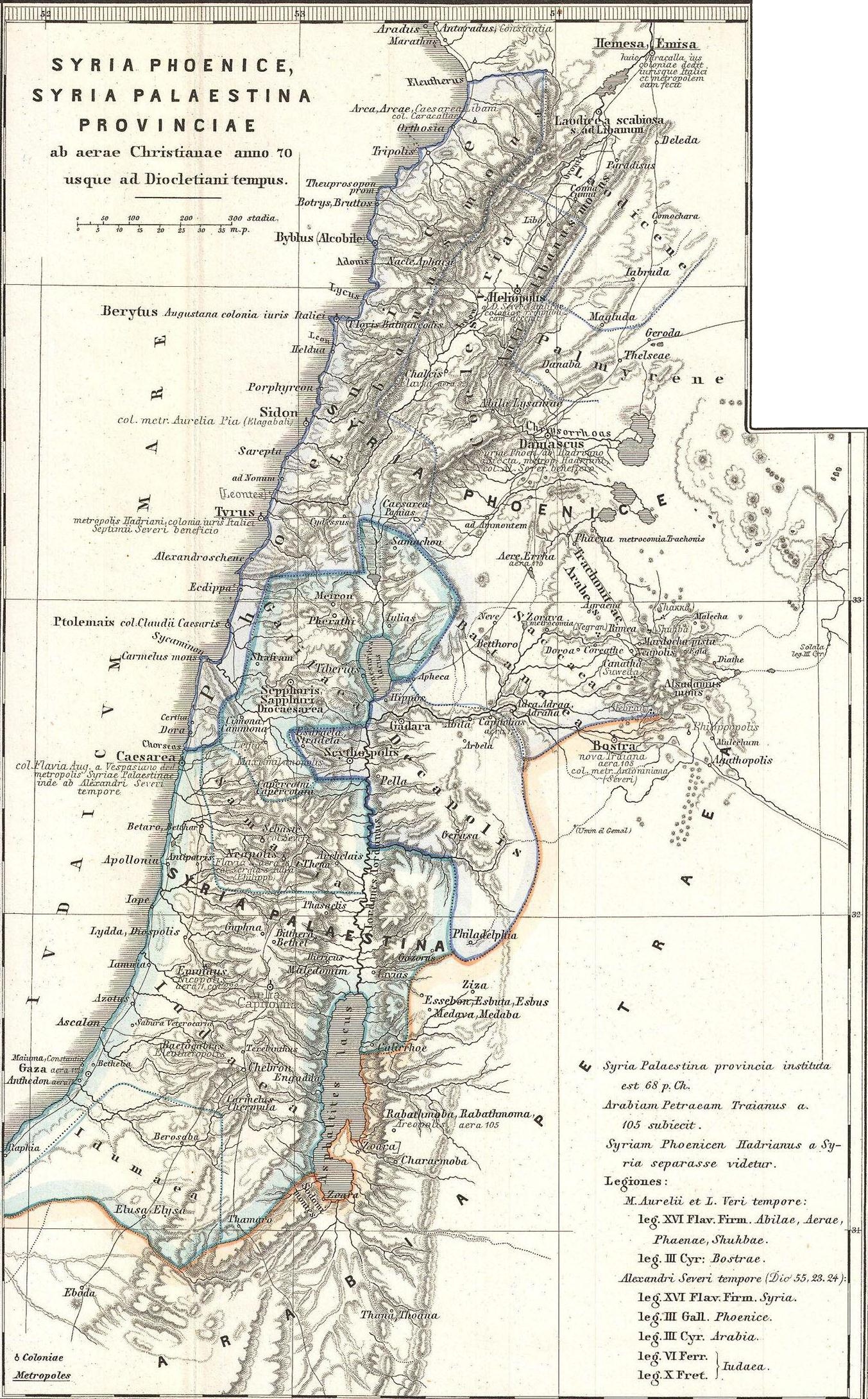
English: This is Karl von Spruner’s 1865 map of the Holy Land, or Israel and Palestine. Essentially nine maps in one, Spruner features two dominant maps and 7 smaller insets, including a Peutinger Table in the lower-right quadrant. The Peutinger Map is an astoundingly important discovery and is today’s only known example of a Roman world map, though the original Peutinger was itself a mediaeval copy of the Roman original. This map also shows, in counter-clock wise order from the Peutinger table, Galilaea, Hierosolyma, Judaea, Palestine at the time of Herod, Syria, Arabia, and Phoeniciae, Palestine, and Arabia. Many of the insets include their own scale or legend. Map notes important cities, rivers, mountain ranges and other minor topographical detail. Territories and countries outlined in color. The whole is rendered in finely engraved detail exhibiting throughout the fine craftsmanship of the Perthes firm. |
||
| Date | 1865 (undated) | ||
| Dimensions | height: 16 in (40.6 cm); width: 13 in (33 cm) | ||
| Accession number |
Geographicus link:
Phoenice-spruner-1865 |
||
| Source/Photographer |
This file was derived from:
1865 Spruner Map of the Holy Land, Israel, or Palestine in Antiquity - Geographicus - Phoenice-spruner-1865.jpg:
|
| This is a
retouched picture, which means that it has been digitally altered from its original version. Modifications: Map divided into 2/3 parts (maps). The original can be viewed here:
1865 Spruner Map of the Holy Land, Israel, or Palestine in Antiquity - Geographicus - Phoenice-spruner-1865.jpg:
|
Licensing
|
This is a faithful photographic reproduction of a two-dimensional,
public domain work of art. The work of art itself is in the public domain for the following reason:
The official position taken by the Wikimedia Foundation is that "faithful reproductions of two-dimensional public domain works of art are public domain".
This photographic reproduction is therefore also considered to be in the public domain in the United States. In other jurisdictions, re-use of this content may be restricted; see Reuse of PD-Art photographs for details. | ||||
Original upload log
This image is a derivative work of the following images:
-
File:1865_Spruner_Map_of_the_Holy_Land,_Israel,_or_Palestine_in_Antiquity_-_Geographicus_-_Phoenice-spruner-1865.jpg licensed with PD-Art
- 2011-03-25T05:57:05Z BotMultichillT 3500x2897 (2712725 Bytes) {{subst:User:Multichill/Geographicus |link=http://www.geographicus.com/P/AntiqueMap/Phoenice-spruner-1865 |product_name=1865 Spruner Map of the Holy Land, Israel, or Palestine in Antiquity |map_title=Phoenice, Coelesyria, Dec
Uploaded with derivativeFX
File history
Click on a date/time to view the file as it appeared at that time.
| Date/Time | Thumbnail | Dimensions | User | Comment | |
|---|---|---|---|---|---|
| current | 08:29, 10 January 2013 |
| 1,353 × 2,180 (1.39 MB) | Cristiano64 | == {{int:filedesc}} == {{Information |Description={{en|This is Karl von Spruner’s 1865 map of the Holy Land, or Israel and Palestine. Essentially nine maps in one, Spruner features two dominant maps and 7 smaller insets, including a Peutinger Table ... |
File usage
Global file usage
The following other wikis use this file:
- Usage on ar.wikipedia.org
- Usage on eo.wikipedia.org
- Usage on it.wikipedia.org
- Usage on mk.wikipedia.org
- Usage on mt.wikipedia.org
- Usage on ru.wikipedia.org
- Usage on zh.wikipedia.org
Original file (1,353 × 2,180 pixels, file size: 1.39 MB, MIME type: image/jpeg)
| This is a file from the
Wikimedia Commons. Information from its
description page there is shown below. Commons is a freely licensed media file repository. You can help. |
Summary
| Author |
|
||
| Description |
English: This is Karl von Spruner’s 1865 map of the Holy Land, or Israel and Palestine. Essentially nine maps in one, Spruner features two dominant maps and 7 smaller insets, including a Peutinger Table in the lower-right quadrant. The Peutinger Map is an astoundingly important discovery and is today’s only known example of a Roman world map, though the original Peutinger was itself a mediaeval copy of the Roman original. This map also shows, in counter-clock wise order from the Peutinger table, Galilaea, Hierosolyma, Judaea, Palestine at the time of Herod, Syria, Arabia, and Phoeniciae, Palestine, and Arabia. Many of the insets include their own scale or legend. Map notes important cities, rivers, mountain ranges and other minor topographical detail. Territories and countries outlined in color. The whole is rendered in finely engraved detail exhibiting throughout the fine craftsmanship of the Perthes firm. |
||
| Date | 1865 (undated) | ||
| Dimensions | height: 16 in (40.6 cm); width: 13 in (33 cm) | ||
| Accession number |
Geographicus link:
Phoenice-spruner-1865 |
||
| Source/Photographer |
This file was derived from:
1865 Spruner Map of the Holy Land, Israel, or Palestine in Antiquity - Geographicus - Phoenice-spruner-1865.jpg:
|
| This is a
retouched picture, which means that it has been digitally altered from its original version. Modifications: Map divided into 2/3 parts (maps). The original can be viewed here:
1865 Spruner Map of the Holy Land, Israel, or Palestine in Antiquity - Geographicus - Phoenice-spruner-1865.jpg:
|
Licensing
|
This is a faithful photographic reproduction of a two-dimensional,
public domain work of art. The work of art itself is in the public domain for the following reason:
The official position taken by the Wikimedia Foundation is that "faithful reproductions of two-dimensional public domain works of art are public domain".
This photographic reproduction is therefore also considered to be in the public domain in the United States. In other jurisdictions, re-use of this content may be restricted; see Reuse of PD-Art photographs for details. | ||||
Original upload log
This image is a derivative work of the following images:
-
File:1865_Spruner_Map_of_the_Holy_Land,_Israel,_or_Palestine_in_Antiquity_-_Geographicus_-_Phoenice-spruner-1865.jpg licensed with PD-Art
- 2011-03-25T05:57:05Z BotMultichillT 3500x2897 (2712725 Bytes) {{subst:User:Multichill/Geographicus |link=http://www.geographicus.com/P/AntiqueMap/Phoenice-spruner-1865 |product_name=1865 Spruner Map of the Holy Land, Israel, or Palestine in Antiquity |map_title=Phoenice, Coelesyria, Dec
Uploaded with derivativeFX
File history
Click on a date/time to view the file as it appeared at that time.
| Date/Time | Thumbnail | Dimensions | User | Comment | |
|---|---|---|---|---|---|
| current | 08:29, 10 January 2013 |
| 1,353 × 2,180 (1.39 MB) | Cristiano64 | == {{int:filedesc}} == {{Information |Description={{en|This is Karl von Spruner’s 1865 map of the Holy Land, or Israel and Palestine. Essentially nine maps in one, Spruner features two dominant maps and 7 smaller insets, including a Peutinger Table ... |
File usage
Global file usage
The following other wikis use this file:
- Usage on ar.wikipedia.org
- Usage on eo.wikipedia.org
- Usage on it.wikipedia.org
- Usage on mk.wikipedia.org
- Usage on mt.wikipedia.org
- Usage on ru.wikipedia.org
- Usage on zh.wikipedia.org