
Original file (1,400 × 985 pixels, file size: 1.17 MB, MIME type: image/jpeg)
| This is a file from the
Wikimedia Commons. Information from its
description page there is shown below. Commons is a freely licensed media file repository. You can help. |
Summary
| Description |
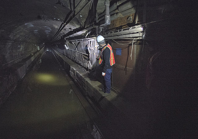
MTA employees using a pump train are working around the clock to pump seawater out of the L train's tunnel under the East River. The tunnel was flooded during the unprecedented 13-foot storm surge of Hurricane Sandy. This photo shows activity on the afternoon of Monday, November 5. After the tunnel is pumped dry of water, work will begin to inspect tracks, signals, switches, electrical components, and third rail. If any repairs are needed, employees will make them as quickly as possible to get service restored. Photo: Metropolitan Transportation Authority / Patrick Cashin. |
| Date | |
| Source | NYCT_5975 |
| Author | Metropolitan Transportation Authority of the State of New York |
| Camera location |
| View this and other nearby images on: OpenStreetMap |
|
|---|
Licensing
- You are free:
- to share – to copy, distribute and transmit the work
- to remix – to adapt the work
- Under the following conditions:
- attribution – You must give appropriate credit, provide a link to the license, and indicate if changes were made. You may do so in any reasonable manner, but not in any way that suggests the licensor endorses you or your use.
| This image, originally posted to Flickr, was reviewed on 28 March 2013 by the administrator or reviewer File Upload Bot (Magnus Manske), who confirmed that it was available on Flickr under the stated license on that date. |
File history
Click on a date/time to view the file as it appeared at that time.
| Date/Time | Thumbnail | Dimensions | User | Comment | |
|---|---|---|---|---|---|
| current | 13:40, 28 March 2013 |
| 1,400 × 985 (1.17 MB) | File Upload Bot (Magnus Manske) | Transferred from Flickr by User:vcohen using flickr2commons |
File usage
Global file usage
The following other wikis use this file:
- Usage on de.wikipedia.org
- Usage on es.wikipedia.org
- Usage on nl.wikipedia.org
- Usage on www.wikidata.org
Metadata
Original file (1,400 × 985 pixels, file size: 1.17 MB, MIME type: image/jpeg)
| This is a file from the
Wikimedia Commons. Information from its
description page there is shown below. Commons is a freely licensed media file repository. You can help. |
Summary
| Description |
MTA employees using a pump train are working around the clock to pump seawater out of the L train's tunnel under the East River. The tunnel was flooded during the unprecedented 13-foot storm surge of Hurricane Sandy. This photo shows activity on the afternoon of Monday, November 5. After the tunnel is pumped dry of water, work will begin to inspect tracks, signals, switches, electrical components, and third rail. If any repairs are needed, employees will make them as quickly as possible to get service restored. Photo: Metropolitan Transportation Authority / Patrick Cashin. |
| Date | |
| Source | NYCT_5975 |
| Author | Metropolitan Transportation Authority of the State of New York |
| Camera location |
| View this and other nearby images on: OpenStreetMap |
|
|---|
Licensing
- You are free:
- to share – to copy, distribute and transmit the work
- to remix – to adapt the work
- Under the following conditions:
- attribution – You must give appropriate credit, provide a link to the license, and indicate if changes were made. You may do so in any reasonable manner, but not in any way that suggests the licensor endorses you or your use.
| This image, originally posted to Flickr, was reviewed on 28 March 2013 by the administrator or reviewer File Upload Bot (Magnus Manske), who confirmed that it was available on Flickr under the stated license on that date. |
File history
Click on a date/time to view the file as it appeared at that time.
| Date/Time | Thumbnail | Dimensions | User | Comment | |
|---|---|---|---|---|---|
| current | 13:40, 28 March 2013 |
| 1,400 × 985 (1.17 MB) | File Upload Bot (Magnus Manske) | Transferred from Flickr by User:vcohen using flickr2commons |
File usage
Global file usage
The following other wikis use this file:
- Usage on de.wikipedia.org
- Usage on es.wikipedia.org
- Usage on nl.wikipedia.org
- Usage on www.wikidata.org