
Size of this preview:
600 Ο½ 600 pixels. Other resolutions:
240 Ο½ 240 pixels |
480 Ο½ 480 pixels |
768 Ο½ 768 pixels |
1,024 Ο½ 1,024 pixels |
1,456 Ο½ 1,456 pixels.
Original file (1,456 Ο½ 1,456 pixels, file size: 1.93 MB, MIME type: image/jpeg)
| This is a file from the
Wikimedia Commons. Information from its
description page there is shown below. Commons is a freely licensed media file repository. You can help. |
Summary
| Description |
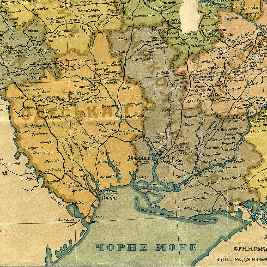
–Θ–Κ―Ä–Α―½–Ϋ―¹―¨–Κ–Α: –û–¥–Β―¹―¨–Κ–Α ―²–Α –€–Η–Κ–Ψ–Μ–Α―½–≤―¹―¨–Κ–Α –≥―É–±–Β―Ä–Ϋ―•―½, ―³―Ä–Α–≥–Φ–Β–Ϋ―² –Φ–Α–Ω–Η –Θ–Κ―Ä–Α―½–Ϋ―¹―¨–Κ–Ψ―½ ―¹–Ψ―Ü. ―Ä–Α–¥. ―Ä–Β―¹–Ω―É–±–Μ―•–Κ–Η, ―¹―•―΅–Β–Ϋ―¨ 1922 |
| Date | |
| Source | –ê–¥–Φ―•–Ϋ―•―¹―²―Ä–Α―Ü―•–Ι–Ϋ–Α –€–Α–Ω–Α –Θ–Κ―Ä–Α―½–Ϋ―¹―¨–Κ–Ψ―½ –Γ–Ψ―Ü.[―•–Α–Μ―•―¹―²–Η―΅–Ϋ–Ψ―½] –†–Α–¥.[―è–Ϋ―¹―¨–Κ–Ψ―½] –†–Β―¹–Ω―É–±–Μ―•–Κ–Η [–ö–Α―Ä―²–Η] : ―¹―•―΅. 1922 ―Ä. / –ù–Α―Ä–Ψ–¥. –ö–Ψ–Φ―•―¹–Α―Ä―•―è―² –£–Ϋ―É―²―Ä. –Γ–Ω―Ä–Α–≤ ; ―É–Κ–Μ–Α–¥. –Γ. –Ξ―É―Ä–≥―•–Ϋ. βÄî 1:1 680 000 ; 40 –≤. ―É 1 –¥―é–Ι–Φ―•. βÄî –Ξ–Α―Ä–Κ―•–≤ : [–ë. –≤–Η–¥-–≤–Α], [1922]. βÄî 1 –Κ. : –Κ–Ψ–Μ―¨–Ψ―Ä., ―²–Α–±–Μ. –Α–¥–Φ. –Ω–Ψ–¥―•–Μ―É, ―à―²–Β–Φ–Ω–Β–Μ―¨ ; 54Ο½74 ―¹–Φ (–ù–ë–Θ–£ –Γ–ö 5364) |
| Author | Unknown author (scan by AMY 2017-01-25) |
Licensing
This file is a Ukrainian or Ukrainian SSR work and it is presently in the
public domain in Ukraine, because it was published before January 1, 1954, and the creator (if known) died before that date (
details).
|
 |
File history
Click on a date/time to view the file as it appeared at that time.
| Date/Time | Thumbnail | Dimensions | User | Comment | |
|---|---|---|---|---|---|
| current | 13:36, 14 August 2018 |
| 1,456 Ο½ 1,456 (1.93 MB) | AMY 81-412 | == {{int:filedesc}} == {{Information |description={{uk|1=–û–¥–Β―¹―¨–Κ–Α ―²–Α –€–Η–Κ–Ψ–Μ–Α―½–≤―¹―¨–Κ–Α –≥―É–±–Β―Ä–Ϋ―•―½, ―³―Ä–Α–≥–Φ–Β–Ϋ―² –Φ–Α–Ω–Η –Θ–Κ―Ä–Α―½–Ϋ―¹―¨–Κ–Ψ―½ ―¹–Ψ―Ü. ―Ä–Α–¥. ―Ä–Β―¹–Ω―É–±–Μ―•–Κ–Η, ―¹―•―΅–Β–Ϋ―¨ 1922}} |date=1922-01 |source= –ê–¥–Φ―•–Ϋ―•―¹―²―Ä–Α―Ü―•–Ι–Ϋ–Α –€–Α–Ω–Α –Θ–Κ―Ä–Α―½–Ϋ―¹―¨–Κ–Ψ―½ –Γ–Ψ―Ü.[―•–Α–Μ―•―¹―²–Η―΅–Ϋ–Ψ―½] –†–Α–¥.[―è–Ϋ―¹―¨–Κ–Ψ―½] –†–Β―¹–Ω―É–±–Μ―•–Κ–Η [–ö–Α―Ä―²–Η] : ―¹―•―΅. 1922 ―Ä. / –ù–Α―Ä–Ψ–¥. –ö–Ψ–Φ―•―¹–Α―Ä―•―è―² –£–Ϋ―É―²―Ä. –Γ–Ω―Ä–Α–≤ ; ―É–Κ–Μ–Α–¥. –Γ. –Ξ―É―Ä–≥―•–Ϋ. βÄî 1:1 680 000 ; 40 –≤. ―É 1 –¥―é–Ι–Φ―•. βÄî –Ξ–Α―Ä–Κ―•–≤ : [–ë. –≤–Η–¥-–≤–Α], [1922]. βÄî 1 –Κ. : –Κ–Ψ–Μ―¨–Ψ―Ä., ―²–Α–±–Μ. –Α–¥–Φ. –Ω–Ψ–¥―•–Μ―É, ―à―²–Β–Φ–Ω–Β–Μ―¨ ; 54Ο½74 ―¹–Φ (–ù–ë–Θ–£ –Γ–ö 5364) |author={{unknown|author}} (sc... |
File usage
The following pages on the English Wikipedia use this file (pages on other projects are not listed):
Global file usage
The following other wikis use this file:
- Usage on da.wikipedia.org
- Usage on el.wikipedia.org
- Usage on hr.wikipedia.org
- Usage on krc.wikipedia.org
- Usage on lv.wikipedia.org
- Usage on pt.wikipedia.org
- Usage on ru.wikipedia.org
- Usage on uk.wikipedia.org
- –†–Ψ–Ζ–¥―•–Μ―¨–Ϋ―è–Ϋ―¹―¨–Κ–Η–Ι ―Ä–Α–Ι–Ψ–Ϋ (1930βÄî2020)
- –€–Ψ–Μ–¥–Α–≤―¹―¨–Κ–Α –ê–≤―²–Ψ–Ϋ–Ψ–Φ–Ϋ–Α –†–Α–¥―è–Ϋ―¹―¨–Κ–Α –Γ–Ψ―Ü―•–Α–Μ―•―¹―²–Η―΅–Ϋ–Α –†–Β―¹–Ω―É–±–Μ―•–Κ–Α
- –€–Η–Κ–Ψ–Μ–Α―½–≤―¹―¨–Κ–Α –≥―É–±–Β―Ä–Ϋ―•―è
- –û–¥–Β―¹―¨–Κ–Α –≥―É–±–Β―Ä–Ϋ―•―è
- –ê–¥–Φ―•–Ϋ―•―¹―²―Ä–Α―²–Η–≤–Ϋ–Η–Ι ―É―¹―²―Ä―•–Ι –û–¥–Β―¹―¨–Κ–Ψ―½ –Ψ–±–Μ–Α―¹―²―•
- –ê–¥–Φ―•–Ϋ―•―¹―²―Ä–Α―²–Η–≤–Ϋ–Η–Ι ―É―¹―²―Ä―•–Ι –€–Η–Κ–Ψ–Μ–Α―½–≤―¹―¨–Κ–Ψ―½ –Ψ–±–Μ–Α―¹―²―•
- –Ü―¹―²–Ψ―Ä―•―è –Ζ–Φ―•–Ϋ –Α–¥–Φ―•–Ϋ―•―¹―²―Ä–Α―²–Η–≤–Ϋ–Ψ-―²–Β―Ä–Η―²–Ψ―Ä―•–Α–Μ―¨–Ϋ–Ψ–≥–Ψ ―É―¹―²―Ä–Ψ―é –û–¥–Β―¹―¨–Κ–Ψ―½ –Ψ–±–Μ–Α―¹―²―•
Metadata
Size of this preview:
600 Ο½ 600 pixels. Other resolutions:
240 Ο½ 240 pixels |
480 Ο½ 480 pixels |
768 Ο½ 768 pixels |
1,024 Ο½ 1,024 pixels |
1,456 Ο½ 1,456 pixels.
Original file (1,456 Ο½ 1,456 pixels, file size: 1.93 MB, MIME type: image/jpeg)
| This is a file from the
Wikimedia Commons. Information from its
description page there is shown below. Commons is a freely licensed media file repository. You can help. |
Summary
| Description |
–Θ–Κ―Ä–Α―½–Ϋ―¹―¨–Κ–Α: –û–¥–Β―¹―¨–Κ–Α ―²–Α –€–Η–Κ–Ψ–Μ–Α―½–≤―¹―¨–Κ–Α –≥―É–±–Β―Ä–Ϋ―•―½, ―³―Ä–Α–≥–Φ–Β–Ϋ―² –Φ–Α–Ω–Η –Θ–Κ―Ä–Α―½–Ϋ―¹―¨–Κ–Ψ―½ ―¹–Ψ―Ü. ―Ä–Α–¥. ―Ä–Β―¹–Ω―É–±–Μ―•–Κ–Η, ―¹―•―΅–Β–Ϋ―¨ 1922 |
| Date | |
| Source | –ê–¥–Φ―•–Ϋ―•―¹―²―Ä–Α―Ü―•–Ι–Ϋ–Α –€–Α–Ω–Α –Θ–Κ―Ä–Α―½–Ϋ―¹―¨–Κ–Ψ―½ –Γ–Ψ―Ü.[―•–Α–Μ―•―¹―²–Η―΅–Ϋ–Ψ―½] –†–Α–¥.[―è–Ϋ―¹―¨–Κ–Ψ―½] –†–Β―¹–Ω―É–±–Μ―•–Κ–Η [–ö–Α―Ä―²–Η] : ―¹―•―΅. 1922 ―Ä. / –ù–Α―Ä–Ψ–¥. –ö–Ψ–Φ―•―¹–Α―Ä―•―è―² –£–Ϋ―É―²―Ä. –Γ–Ω―Ä–Α–≤ ; ―É–Κ–Μ–Α–¥. –Γ. –Ξ―É―Ä–≥―•–Ϋ. βÄî 1:1 680 000 ; 40 –≤. ―É 1 –¥―é–Ι–Φ―•. βÄî –Ξ–Α―Ä–Κ―•–≤ : [–ë. –≤–Η–¥-–≤–Α], [1922]. βÄî 1 –Κ. : –Κ–Ψ–Μ―¨–Ψ―Ä., ―²–Α–±–Μ. –Α–¥–Φ. –Ω–Ψ–¥―•–Μ―É, ―à―²–Β–Φ–Ω–Β–Μ―¨ ; 54Ο½74 ―¹–Φ (–ù–ë–Θ–£ –Γ–ö 5364) |
| Author | Unknown author (scan by AMY 2017-01-25) |
Licensing
This file is a Ukrainian or Ukrainian SSR work and it is presently in the
public domain in Ukraine, because it was published before January 1, 1954, and the creator (if known) died before that date (
details).
|
|
File history
Click on a date/time to view the file as it appeared at that time.
| Date/Time | Thumbnail | Dimensions | User | Comment | |
|---|---|---|---|---|---|
| current | 13:36, 14 August 2018 |
| 1,456 Ο½ 1,456 (1.93 MB) | AMY 81-412 | == {{int:filedesc}} == {{Information |description={{uk|1=–û–¥–Β―¹―¨–Κ–Α ―²–Α –€–Η–Κ–Ψ–Μ–Α―½–≤―¹―¨–Κ–Α –≥―É–±–Β―Ä–Ϋ―•―½, ―³―Ä–Α–≥–Φ–Β–Ϋ―² –Φ–Α–Ω–Η –Θ–Κ―Ä–Α―½–Ϋ―¹―¨–Κ–Ψ―½ ―¹–Ψ―Ü. ―Ä–Α–¥. ―Ä–Β―¹–Ω―É–±–Μ―•–Κ–Η, ―¹―•―΅–Β–Ϋ―¨ 1922}} |date=1922-01 |source= –ê–¥–Φ―•–Ϋ―•―¹―²―Ä–Α―Ü―•–Ι–Ϋ–Α –€–Α–Ω–Α –Θ–Κ―Ä–Α―½–Ϋ―¹―¨–Κ–Ψ―½ –Γ–Ψ―Ü.[―•–Α–Μ―•―¹―²–Η―΅–Ϋ–Ψ―½] –†–Α–¥.[―è–Ϋ―¹―¨–Κ–Ψ―½] –†–Β―¹–Ω―É–±–Μ―•–Κ–Η [–ö–Α―Ä―²–Η] : ―¹―•―΅. 1922 ―Ä. / –ù–Α―Ä–Ψ–¥. –ö–Ψ–Φ―•―¹–Α―Ä―•―è―² –£–Ϋ―É―²―Ä. –Γ–Ω―Ä–Α–≤ ; ―É–Κ–Μ–Α–¥. –Γ. –Ξ―É―Ä–≥―•–Ϋ. βÄî 1:1 680 000 ; 40 –≤. ―É 1 –¥―é–Ι–Φ―•. βÄî –Ξ–Α―Ä–Κ―•–≤ : [–ë. –≤–Η–¥-–≤–Α], [1922]. βÄî 1 –Κ. : –Κ–Ψ–Μ―¨–Ψ―Ä., ―²–Α–±–Μ. –Α–¥–Φ. –Ω–Ψ–¥―•–Μ―É, ―à―²–Β–Φ–Ω–Β–Μ―¨ ; 54Ο½74 ―¹–Φ (–ù–ë–Θ–£ –Γ–ö 5364) |author={{unknown|author}} (sc... |
File usage
The following pages on the English Wikipedia use this file (pages on other projects are not listed):
Global file usage
The following other wikis use this file:
- Usage on da.wikipedia.org
- Usage on el.wikipedia.org
- Usage on hr.wikipedia.org
- Usage on krc.wikipedia.org
- Usage on lv.wikipedia.org
- Usage on pt.wikipedia.org
- Usage on ru.wikipedia.org
- Usage on uk.wikipedia.org
- –†–Ψ–Ζ–¥―•–Μ―¨–Ϋ―è–Ϋ―¹―¨–Κ–Η–Ι ―Ä–Α–Ι–Ψ–Ϋ (1930βÄî2020)
- –€–Ψ–Μ–¥–Α–≤―¹―¨–Κ–Α –ê–≤―²–Ψ–Ϋ–Ψ–Φ–Ϋ–Α –†–Α–¥―è–Ϋ―¹―¨–Κ–Α –Γ–Ψ―Ü―•–Α–Μ―•―¹―²–Η―΅–Ϋ–Α –†–Β―¹–Ω―É–±–Μ―•–Κ–Α
- –€–Η–Κ–Ψ–Μ–Α―½–≤―¹―¨–Κ–Α –≥―É–±–Β―Ä–Ϋ―•―è
- –û–¥–Β―¹―¨–Κ–Α –≥―É–±–Β―Ä–Ϋ―•―è
- –ê–¥–Φ―•–Ϋ―•―¹―²―Ä–Α―²–Η–≤–Ϋ–Η–Ι ―É―¹―²―Ä―•–Ι –û–¥–Β―¹―¨–Κ–Ψ―½ –Ψ–±–Μ–Α―¹―²―•
- –ê–¥–Φ―•–Ϋ―•―¹―²―Ä–Α―²–Η–≤–Ϋ–Η–Ι ―É―¹―²―Ä―•–Ι –€–Η–Κ–Ψ–Μ–Α―½–≤―¹―¨–Κ–Ψ―½ –Ψ–±–Μ–Α―¹―²―•
- –Ü―¹―²–Ψ―Ä―•―è –Ζ–Φ―•–Ϋ –Α–¥–Φ―•–Ϋ―•―¹―²―Ä–Α―²–Η–≤–Ϋ–Ψ-―²–Β―Ä–Η―²–Ψ―Ä―•–Α–Μ―¨–Ϋ–Ψ–≥–Ψ ―É―¹―²―Ä–Ψ―é –û–¥–Β―¹―¨–Κ–Ψ―½ –Ψ–±–Μ–Α―¹―²―•