Size of this preview:
800 × 583 pixels. Other resolutions:
320 × 233 pixels |
640 × 466 pixels |
936 × 682 pixels.
Original file (936 × 682 pixels, file size: 33 KB, MIME type: image/png)
| This is a file from the
Wikimedia Commons. Information from its
description page there is shown below. Commons is a freely licensed media file repository. You can help. |
| Description |
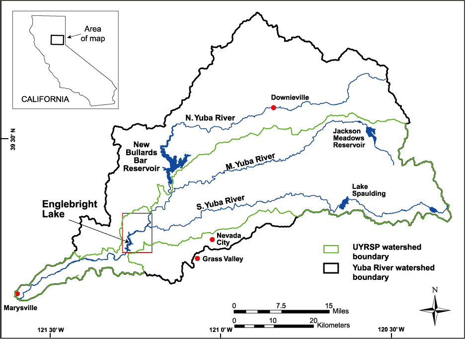
English: Map of the watershed of the Yuba River in Nevada and Yuba Counties, California, USA. Map drawn by the U.S. Geological Service (USGS) for bathymetric and geophysical surveys of Englebright Lake, which is impounded by Englebright Dam on the Yuba River. The black borders encompass the entire watershed of the three forks of the Yuba River. The green borders encompass the limits of the USGS Upper Yuba River Watershed Studies Program (UYRSP) area. Map slightly reworked by contributor from source map and converted to PNG. |
|||
| Location | not specified or unknown | |||
| Date | not specified or unknown | |||
| Source |
U.S. Geological Survey, Western Region Coastal and Marine Geology Image page Image description page USGS home page |
|||
| Author | U.S. Geological Survey, artist not specified or unknown | |||
| Permission ( Reusing this file) |
|
File history
Click on a date/time to view the file as it appeared at that time.
| Date/Time | Thumbnail | Dimensions | User | Comment | |
|---|---|---|---|---|---|
| current | 16:02, 5 May 2007 |
| 936 × 682 (33 KB) | DanMS | Uploaded new version to correct problems with transparent color. |
| 15:59, 5 May 2007 |
 | 936 × 682 (33 KB) | DanMS | {{Information | Description = {{en|Map of the watershed of the Yuba River in Nevada and Yuba Counties, California, USA. Map drawn by the U.S. Geological Service (USGS) for bathymetric and geophysical surveys of Englebright Lake, which is impounded by E |
File usage
The following pages on the English Wikipedia use this file (pages on other projects are not listed):
Global file usage
The following other wikis use this file:
- Usage on de.wikipedia.org
- Usage on fr.wikipedia.org
- Usage on nl.wikipedia.org
- Usage on www.wikidata.org
Size of this preview:
800 × 583 pixels. Other resolutions:
320 × 233 pixels |
640 × 466 pixels |
936 × 682 pixels.
Original file (936 × 682 pixels, file size: 33 KB, MIME type: image/png)
| This is a file from the
Wikimedia Commons. Information from its
description page there is shown below. Commons is a freely licensed media file repository. You can help. |
| Description |
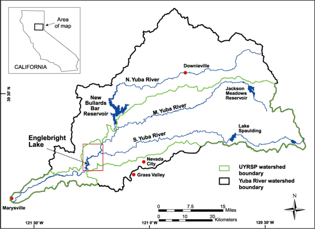
English: Map of the watershed of the Yuba River in Nevada and Yuba Counties, California, USA. Map drawn by the U.S. Geological Service (USGS) for bathymetric and geophysical surveys of Englebright Lake, which is impounded by Englebright Dam on the Yuba River. The black borders encompass the entire watershed of the three forks of the Yuba River. The green borders encompass the limits of the USGS Upper Yuba River Watershed Studies Program (UYRSP) area. Map slightly reworked by contributor from source map and converted to PNG. |
|||
| Location | not specified or unknown | |||
| Date | not specified or unknown | |||
| Source |
U.S. Geological Survey, Western Region Coastal and Marine Geology Image page Image description page USGS home page |
|||
| Author | U.S. Geological Survey, artist not specified or unknown | |||
| Permission ( Reusing this file) |
|
File history
Click on a date/time to view the file as it appeared at that time.
| Date/Time | Thumbnail | Dimensions | User | Comment | |
|---|---|---|---|---|---|
| current | 16:02, 5 May 2007 |
| 936 × 682 (33 KB) | DanMS | Uploaded new version to correct problems with transparent color. |
| 15:59, 5 May 2007 |
| 936 × 682 (33 KB) | DanMS | {{Information | Description = {{en|Map of the watershed of the Yuba River in Nevada and Yuba Counties, California, USA. Map drawn by the U.S. Geological Service (USGS) for bathymetric and geophysical surveys of Englebright Lake, which is impounded by E |
File usage
The following pages on the English Wikipedia use this file (pages on other projects are not listed):
Global file usage
The following other wikis use this file:
- Usage on de.wikipedia.org
- Usage on fr.wikipedia.org
- Usage on nl.wikipedia.org
- Usage on www.wikidata.org