Photos • Location


Size of this preview:
800 × 350 pixels. Other resolutions:
320 × 140 pixels |
640 × 280 pixels |
1,600 × 700 pixels.
Original file (1,600 × 700 pixels, file size: 1.95 MB, MIME type: image/png)
| This is a file from the
Wikimedia Commons. Information from its
description page there is shown below. Commons is a freely licensed media file repository. You can help. |
Summary
| Camera location | | View this and other nearby images on: OpenStreetMap |
|
|---|
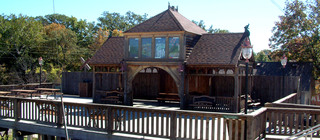
| Description | The pavilion at Williamsport Falls, the highest waterfall in the U.S. state of Indiana, located in the town of Williamsport. |
| Date | |
| Source | Self-photographed |
| Author | Huw Williams ( Huwmanbeing) |
| Permission ( Reusing this file) |
I release this photo into the public domain |
Licensing
| I, the copyright holder of this work, release this work into the
public domain. This applies worldwide. In some countries this may not be legally possible; if so: I grant anyone the right to use this work for any purpose, without any conditions, unless such conditions are required by law. |
File history
Click on a date/time to view the file as it appeared at that time.
| Date/Time | Thumbnail | Dimensions | User | Comment | |
|---|---|---|---|---|---|
| current | 17:42, 14 October 2006 |
| 1,600 × 700 (1.95 MB) | Huwmanbeing | {{Information |Description = The pavilion at Williamsport Falls, the highest waterfall in the U.S. state of Indiana, located in the town of Williamsport, Indiana. |Source = Own photo |Date = 2006-10-06 |Author = Huw Williams ([[User:Huwmanbeing|Huwmanbein |
File usage
The following pages on the English Wikipedia use this file (pages on other projects are not listed):
Metadata
Size of this preview:
800 × 350 pixels. Other resolutions:
320 × 140 pixels |
640 × 280 pixels |
1,600 × 700 pixels.
Original file (1,600 × 700 pixels, file size: 1.95 MB, MIME type: image/png)
| This is a file from the
Wikimedia Commons. Information from its
description page there is shown below. Commons is a freely licensed media file repository. You can help. |
Summary
| Camera location | | View this and other nearby images on: OpenStreetMap |
|
|---|
| Description | The pavilion at Williamsport Falls, the highest waterfall in the U.S. state of Indiana, located in the town of Williamsport. |
| Date | |
| Source | Self-photographed |
| Author | Huw Williams ( Huwmanbeing) |
| Permission ( Reusing this file) |
I release this photo into the public domain |
Licensing
| I, the copyright holder of this work, release this work into the
public domain. This applies worldwide. In some countries this may not be legally possible; if so: I grant anyone the right to use this work for any purpose, without any conditions, unless such conditions are required by law. |
File history
Click on a date/time to view the file as it appeared at that time.
| Date/Time | Thumbnail | Dimensions | User | Comment | |
|---|---|---|---|---|---|
| current | 17:42, 14 October 2006 |
| 1,600 × 700 (1.95 MB) | Huwmanbeing | {{Information |Description = The pavilion at Williamsport Falls, the highest waterfall in the U.S. state of Indiana, located in the town of Williamsport, Indiana. |Source = Own photo |Date = 2006-10-06 |Author = Huw Williams ([[User:Huwmanbeing|Huwmanbein |
File usage
The following pages on the English Wikipedia use this file (pages on other projects are not listed):