Photos • Location


Size of this preview:
800 × 600 pixels. Other resolutions:
320 × 240 pixels |
640 × 480 pixels |
1,024 × 768 pixels |
1,280 × 960 pixels |
2,560 × 1,920 pixels |
2,816 × 2,112 pixels.
Original file (2,816 × 2,112 pixels, file size: 2.3 MB, MIME type: image/jpeg)
| This is a file from the
Wikimedia Commons. Information from its
description page there is shown below. Commons is a freely licensed media file repository. You can help. |
| Camera location |
| View this and other nearby images on: OpenStreetMap |
|
|---|
| Description |
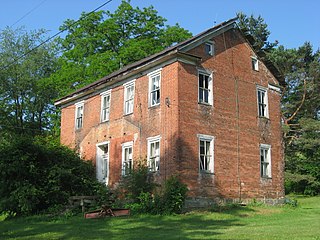
English: Front and northern side of the William P. Hay House, located along the western side of Jimtown Road in
Jefferson Township,
Somerset County,
Pennsylvania,
United States. It was built circa 1870 in the then-antiquated Federal style. |
||
| Date | Taken on 21 June 2013 | ||
| Source | Own work | ||
| Author | Nyttend | ||
| Permission ( Reusing this file) |
|
File history
Click on a date/time to view the file as it appeared at that time.
| Date/Time | Thumbnail | Dimensions | User | Comment | |
|---|---|---|---|---|---|
| current | 03:26, 16 October 2013 |
| 2,816 × 2,112 (2.3 MB) | Nyttend | {{Location|40|0|51.5|N|79|13|16|W}} {{Information |Description={{en|Front and northern side of the William P. Hay House, located along the western side of Jimtown Road in {{w|Jefferson Township, Somerset County, Pennsylvania|Jefferson Township}}, {{w|S... |
File usage
The following pages on the English Wikipedia use this file (pages on other projects are not listed):
Global file usage
The following other wikis use this file:
- Usage on es.wikipedia.org
- Usage on uk.wikipedia.org
- Usage on ur.wikipedia.org
- Usage on vi.wikipedia.org
- Usage on www.wikidata.org
Metadata
Size of this preview:
800 × 600 pixels. Other resolutions:
320 × 240 pixels |
640 × 480 pixels |
1,024 × 768 pixels |
1,280 × 960 pixels |
2,560 × 1,920 pixels |
2,816 × 2,112 pixels.
Original file (2,816 × 2,112 pixels, file size: 2.3 MB, MIME type: image/jpeg)
| This is a file from the
Wikimedia Commons. Information from its
description page there is shown below. Commons is a freely licensed media file repository. You can help. |
| Camera location |
| View this and other nearby images on: OpenStreetMap |
|
|---|
| Description |
English: Front and northern side of the William P. Hay House, located along the western side of Jimtown Road in
Jefferson Township,
Somerset County,
Pennsylvania,
United States. It was built circa 1870 in the then-antiquated Federal style. |
||
| Date | Taken on 21 June 2013 | ||
| Source | Own work | ||
| Author | Nyttend | ||
| Permission ( Reusing this file) |
|
File history
Click on a date/time to view the file as it appeared at that time.
| Date/Time | Thumbnail | Dimensions | User | Comment | |
|---|---|---|---|---|---|
| current | 03:26, 16 October 2013 |
| 2,816 × 2,112 (2.3 MB) | Nyttend | {{Location|40|0|51.5|N|79|13|16|W}} {{Information |Description={{en|Front and northern side of the William P. Hay House, located along the western side of Jimtown Road in {{w|Jefferson Township, Somerset County, Pennsylvania|Jefferson Township}}, {{w|S... |
File usage
The following pages on the English Wikipedia use this file (pages on other projects are not listed):
Global file usage
The following other wikis use this file:
- Usage on es.wikipedia.org
- Usage on uk.wikipedia.org
- Usage on ur.wikipedia.org
- Usage on vi.wikipedia.org
- Usage on www.wikidata.org