
Size of this preview:
685 × 599 pixels. Other resolutions:
274 × 240 pixels |
549 × 480 pixels |
878 × 768 pixels |
1,171 × 1,024 pixels |
2,307 × 2,018 pixels.
Original file (2,307 × 2,018 pixels, file size: 1.35 MB, MIME type: image/png)
| This is a file from the
Wikimedia Commons. Information from its
description page there is shown below. Commons is a freely licensed media file repository. You can help. |
Summary
| Description |
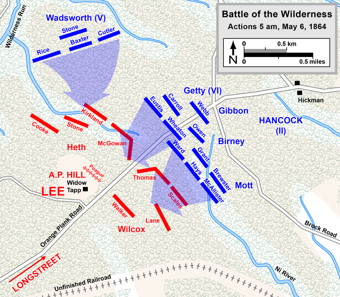
English: Map of a portion of the
Battle of the Wilderness of the
American Civil War. Drawn in Adobe Illustrator CC 2015 by Hal Jespersen. Graphic source file is available at
http://www.CWmaps.com/ |
| Date | |
| Source | Own work (Map is comparable to page 284 map in The Battle of the Wilderness May 5-6, 1864, by Gordon C. Rhea) |
| Author | Hlj |
Licensing
This file is licensed under the
Creative Commons
Attribution 3.0 Unported license.
Attribution: Map by Hal Jespersen, www.CWmaps.com
- You are free:
- to share – to copy, distribute and transmit the work
- to remix – to adapt the work
- Under the following conditions:
- attribution – You must give appropriate credit, provide a link to the license, and indicate if changes were made. You may do so in any reasonable manner, but not in any way that suggests the licensor endorses you or your use.
File history
Click on a date/time to view the file as it appeared at that time.
| Date/Time | Thumbnail | Dimensions | User | Comment | |
|---|---|---|---|---|---|
| current | 21:35, 16 October 2015 |
| 2,307 × 2,018 (1.35 MB) | Hlj | Fix typos and make minor graphical improvements. Same license. |
| 20:02, 17 March 2011 |
 | 1,153 × 1,009 (579 KB) | Hlj | Minor graphical changes to conform to new ACW map style for roads and rivers. Same license. | |
| 01:47, 23 October 2010 |
 | 1,153 × 1,009 (545 KB) | Hlj | Corrected some Confederate troop positions and movements. Same license. | |
| 00:55, 21 October 2010 |
 | 1,153 × 1,009 (531 KB) | Hlj | {{Information |Description={{en|1=Map of a portion of the Battle of the Wilderness of the American Civil War. Drawn in Adobe Illustrator CS5 by Hal Jespersen. Graphic source file is available at http://www.posix.com/CWmaps/}} |Source={{own}} |Auth |
File usage
The following pages on the English Wikipedia use this file (pages on other projects are not listed):
Global file usage
The following other wikis use this file:
- Usage on de.wikipedia.org
- Usage on hu.wikipedia.org
- Usage on hy.wikipedia.org
- Usage on nl.wikipedia.org
- Usage on ru.wikipedia.org
Metadata
Size of this preview:
685 × 599 pixels. Other resolutions:
274 × 240 pixels |
549 × 480 pixels |
878 × 768 pixels |
1,171 × 1,024 pixels |
2,307 × 2,018 pixels.
Original file (2,307 × 2,018 pixels, file size: 1.35 MB, MIME type: image/png)
| This is a file from the
Wikimedia Commons. Information from its
description page there is shown below. Commons is a freely licensed media file repository. You can help. |
Summary
| Description |
English: Map of a portion of the
Battle of the Wilderness of the
American Civil War. Drawn in Adobe Illustrator CC 2015 by Hal Jespersen. Graphic source file is available at
http://www.CWmaps.com/ |
| Date | |
| Source | Own work (Map is comparable to page 284 map in The Battle of the Wilderness May 5-6, 1864, by Gordon C. Rhea) |
| Author | Hlj |
Licensing
This file is licensed under the
Creative Commons
Attribution 3.0 Unported license.
Attribution: Map by Hal Jespersen, www.CWmaps.com
- You are free:
- to share – to copy, distribute and transmit the work
- to remix – to adapt the work
- Under the following conditions:
- attribution – You must give appropriate credit, provide a link to the license, and indicate if changes were made. You may do so in any reasonable manner, but not in any way that suggests the licensor endorses you or your use.
File history
Click on a date/time to view the file as it appeared at that time.
| Date/Time | Thumbnail | Dimensions | User | Comment | |
|---|---|---|---|---|---|
| current | 21:35, 16 October 2015 |
| 2,307 × 2,018 (1.35 MB) | Hlj | Fix typos and make minor graphical improvements. Same license. |
| 20:02, 17 March 2011 |
| 1,153 × 1,009 (579 KB) | Hlj | Minor graphical changes to conform to new ACW map style for roads and rivers. Same license. | |
| 01:47, 23 October 2010 |
| 1,153 × 1,009 (545 KB) | Hlj | Corrected some Confederate troop positions and movements. Same license. | |
| 00:55, 21 October 2010 |
| 1,153 × 1,009 (531 KB) | Hlj | {{Information |Description={{en|1=Map of a portion of the Battle of the Wilderness of the American Civil War. Drawn in Adobe Illustrator CS5 by Hal Jespersen. Graphic source file is available at http://www.posix.com/CWmaps/}} |Source={{own}} |Auth |
File usage
The following pages on the English Wikipedia use this file (pages on other projects are not listed):
Global file usage
The following other wikis use this file:
- Usage on de.wikipedia.org
- Usage on hu.wikipedia.org
- Usage on hy.wikipedia.org
- Usage on nl.wikipedia.org
- Usage on ru.wikipedia.org