
Size of this PNG preview of this SVG file:
800 × 389 pixels. Other resolutions:
320 × 156 pixels |
640 × 311 pixels |
1,024 × 498 pixels |
1,280 × 622 pixels |
2,560 × 1,244 pixels |
1,790 × 870 pixels.
Original file (SVG file, nominally 1,790 × 870 pixels, file size: 914 KB)
| This is a file from the
Wikimedia Commons. Information from its
description page there is shown below. Commons is a freely licensed media file repository. You can help. |
Summary
| Description |
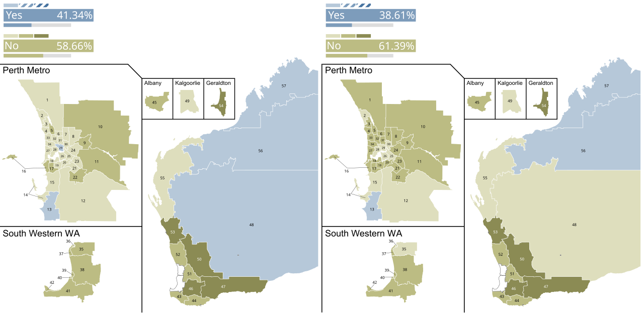
English: The map on the left shows the voting on the first question (weeknight trading), while the map on the right shows the voting on the second one (Sunday trading). Both maps show insets for the
Perth Metropolitan Region, the southwestern part of Western Australia, as well as the cities of Albany, Kalgoorlie and Geraldton. The shapelines were taken from FIle:2005 Western Australian election - Vote Strength.svg and the small numbers correlate with that file's, too. |
| Date | |
| Source | Own work |
| Author | GlebRyabov |
Licensing
I, the copyright holder of this work, hereby publish it under the following license:
| This file is made available under the Creative Commons CC0 1.0 Universal Public Domain Dedication. | |
| The person who associated a work with this deed has dedicated the work to the
public domain by waiving all of their rights to the work worldwide under copyright law, including all related and neighboring rights, to the extent allowed by law. You can copy, modify, distribute and perform the work, even for commercial purposes, all without asking permission.
|
File history
Click on a date/time to view the file as it appeared at that time.
| Date/Time | Thumbnail | Dimensions | User | Comment | |
|---|---|---|---|---|---|
| current | 08:46, 6 May 2024 |
| 1,790 × 870 (914 KB) | MapperGuy87 | Uploaded own work with UploadWizard |
File usage
The following pages on the English Wikipedia use this file (pages on other projects are not listed):
Metadata
Size of this PNG preview of this SVG file:
800 × 389 pixels. Other resolutions:
320 × 156 pixels |
640 × 311 pixels |
1,024 × 498 pixels |
1,280 × 622 pixels |
2,560 × 1,244 pixels |
1,790 × 870 pixels.
Original file (SVG file, nominally 1,790 × 870 pixels, file size: 914 KB)
| This is a file from the
Wikimedia Commons. Information from its
description page there is shown below. Commons is a freely licensed media file repository. You can help. |
Summary
| Description |
English: The map on the left shows the voting on the first question (weeknight trading), while the map on the right shows the voting on the second one (Sunday trading). Both maps show insets for the
Perth Metropolitan Region, the southwestern part of Western Australia, as well as the cities of Albany, Kalgoorlie and Geraldton. The shapelines were taken from FIle:2005 Western Australian election - Vote Strength.svg and the small numbers correlate with that file's, too. |
| Date | |
| Source | Own work |
| Author | GlebRyabov |
Licensing
I, the copyright holder of this work, hereby publish it under the following license:
| This file is made available under the Creative Commons CC0 1.0 Universal Public Domain Dedication. | |
| The person who associated a work with this deed has dedicated the work to the
public domain by waiving all of their rights to the work worldwide under copyright law, including all related and neighboring rights, to the extent allowed by law. You can copy, modify, distribute and perform the work, even for commercial purposes, all without asking permission.
|
File history
Click on a date/time to view the file as it appeared at that time.
| Date/Time | Thumbnail | Dimensions | User | Comment | |
|---|---|---|---|---|---|
| current | 08:46, 6 May 2024 |
| 1,790 × 870 (914 KB) | MapperGuy87 | Uploaded own work with UploadWizard |
File usage
The following pages on the English Wikipedia use this file (pages on other projects are not listed):