
Size of this preview:
633 × 600 pixels. Other resolutions:
253 × 240 pixels |
507 × 480 pixels |
937 × 888 pixels.
Original file (937 × 888 pixels, file size: 139 KB, MIME type: image/png)
| This is a file from the
Wikimedia Commons. Information from its
description page there is shown below. Commons is a freely licensed media file repository. You can help. |
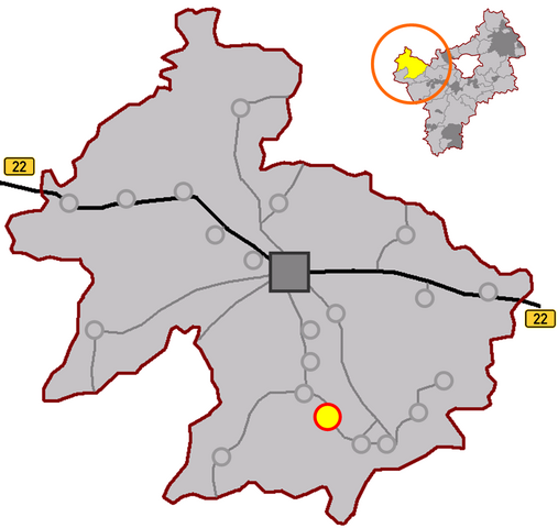
Description: position of villages belonging to the German town of
Hollfeld in
Landkreis Bayreuth
Source: own work --
Immanuel Giel 08:13, 16 April 2007 (UTC)
| I, the copyright holder of this work, release this work into the
public domain. This applies worldwide. In some countries this may not be legally possible; if so: I grant anyone the right to use this work for any purpose, without any conditions, unless such conditions are required by law. |
File history
Click on a date/time to view the file as it appeared at that time.
| Date/Time | Thumbnail | Dimensions | User | Comment | |
|---|---|---|---|---|---|
| current | 10:25, 16 April 2007 |
| 937 × 888 (139 KB) | Immanuel Giel | Description: position of villages belonging to the German town of Hollfeld in Landkreis Bayreuth<br> Source: own work --~~~~ {{PD-self}} Category:Maps of Hollfeld |
| 10:24, 16 April 2007 |
 | 937 × 888 (139 KB) | Immanuel Giel | Description: position of villages belonging to the German town of Hollfeld in Landkreis Bayreuth<br> Source: own work --~~~~ {{PD-self}} Category:Maps of Hollfeld | |
| 08:13, 16 April 2007 |
 | 940 × 896 (139 KB) | Immanuel Giel | Description: position of villages belonging to the German town of Hollfeld in Landkreis Bayreuth<br> Source: own work --~~~~ Category:Maps of Hollfeld |
File usage
The following pages on the English Wikipedia use this file (pages on other projects are not listed):
Global file usage
The following other wikis use this file:
- Usage on de.wikipedia.org
- Usage on eo.wikipedia.org
- Usage on it.wikipedia.org
- Usage on ja.wikipedia.org
- Usage on ky.wikipedia.org
- Usage on nl.wikipedia.org
- Usage on pl.wikipedia.org
- Usage on pt.wikipedia.org
- Usage on vi.wikipedia.org
- Usage on www.wikidata.org
Size of this preview:
633 × 600 pixels. Other resolutions:
253 × 240 pixels |
507 × 480 pixels |
937 × 888 pixels.
Original file (937 × 888 pixels, file size: 139 KB, MIME type: image/png)
| This is a file from the
Wikimedia Commons. Information from its
description page there is shown below. Commons is a freely licensed media file repository. You can help. |
Description: position of villages belonging to the German town of
Hollfeld in
Landkreis Bayreuth
Source: own work --
Immanuel Giel 08:13, 16 April 2007 (UTC)
| I, the copyright holder of this work, release this work into the
public domain. This applies worldwide. In some countries this may not be legally possible; if so: I grant anyone the right to use this work for any purpose, without any conditions, unless such conditions are required by law. |
File history
Click on a date/time to view the file as it appeared at that time.
| Date/Time | Thumbnail | Dimensions | User | Comment | |
|---|---|---|---|---|---|
| current | 10:25, 16 April 2007 |
| 937 × 888 (139 KB) | Immanuel Giel | Description: position of villages belonging to the German town of Hollfeld in Landkreis Bayreuth<br> Source: own work --~~~~ {{PD-self}} Category:Maps of Hollfeld |
| 10:24, 16 April 2007 |
| 937 × 888 (139 KB) | Immanuel Giel | Description: position of villages belonging to the German town of Hollfeld in Landkreis Bayreuth<br> Source: own work --~~~~ {{PD-self}} Category:Maps of Hollfeld | |
| 08:13, 16 April 2007 |
| 940 × 896 (139 KB) | Immanuel Giel | Description: position of villages belonging to the German town of Hollfeld in Landkreis Bayreuth<br> Source: own work --~~~~ Category:Maps of Hollfeld |
File usage
The following pages on the English Wikipedia use this file (pages on other projects are not listed):
Global file usage
The following other wikis use this file:
- Usage on de.wikipedia.org
- Usage on eo.wikipedia.org
- Usage on it.wikipedia.org
- Usage on ja.wikipedia.org
- Usage on ky.wikipedia.org
- Usage on nl.wikipedia.org
- Usage on pl.wikipedia.org
- Usage on pt.wikipedia.org
- Usage on vi.wikipedia.org
- Usage on www.wikidata.org