
Size of this JPG preview of this TIF file:
762 × 600 pixels. Other resolutions:
305 × 240 pixels |
610 × 480 pixels |
976 × 768 pixels |
1,280 × 1,008 pixels |
2,560 × 2,016 pixels |
4,816 × 3,792 pixels.
Original file (4,816 × 3,792 pixels, file size: 133 KB, MIME type: image/tiff)
| This is a file from the
Wikimedia Commons. Information from its
description page there is shown below. Commons is a freely licensed media file repository. You can help. |
| Description |
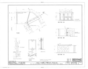
English: Drawing of a Waste Weir on the Chesapeake and Ohio Canal at 109.32 miles (just above Lock 50 on the 14 mile level)from HABS MD-219 |
|||||
| Date | after 1933 | |||||
| Source | http://www.historicmapworks.com/Buildings/index.php?state=MD&city=Williamsport%20vicinity&id=16576 | |||||
| Author | Historic American Buildings Survey, US Department of the Interior | |||||
| Permission ( Reusing this file) |
|

File history
Click on a date/time to view the file as it appeared at that time.
| Date/Time | Thumbnail | Dimensions | User | Comment | |
|---|---|---|---|---|---|
| current | 22:57, 1 December 2013 |
 | 4,816 × 3,792 (133 KB) | Bonnachoven | {{Information |Description ={{en|1=Drawing of a Waste Weir on the Chesapeake and Ohio Canal at 109.32 miles (just above Lock 50 on the 14 mile level)from HABS MD-219 }} |Source =http://www.historicmapworks.com/Buildings/index.php?state=MD&ci... |
File usage
The following pages on the English Wikipedia use this file (pages on other projects are not listed):
Metadata
Size of this JPG preview of this TIF file:
762 × 600 pixels. Other resolutions:
305 × 240 pixels |
610 × 480 pixels |
976 × 768 pixels |
1,280 × 1,008 pixels |
2,560 × 2,016 pixels |
4,816 × 3,792 pixels.
Original file (4,816 × 3,792 pixels, file size: 133 KB, MIME type: image/tiff)
| This is a file from the
Wikimedia Commons. Information from its
description page there is shown below. Commons is a freely licensed media file repository. You can help. |
| Description |
English: Drawing of a Waste Weir on the Chesapeake and Ohio Canal at 109.32 miles (just above Lock 50 on the 14 mile level)from HABS MD-219 |
|||||
| Date | after 1933 | |||||
| Source | http://www.historicmapworks.com/Buildings/index.php?state=MD&city=Williamsport%20vicinity&id=16576 | |||||
| Author | Historic American Buildings Survey, US Department of the Interior | |||||
| Permission ( Reusing this file) |
|
File history
Click on a date/time to view the file as it appeared at that time.
| Date/Time | Thumbnail | Dimensions | User | Comment | |
|---|---|---|---|---|---|
| current | 22:57, 1 December 2013 |
| 4,816 × 3,792 (133 KB) | Bonnachoven | {{Information |Description ={{en|1=Drawing of a Waste Weir on the Chesapeake and Ohio Canal at 109.32 miles (just above Lock 50 on the 14 mile level)from HABS MD-219 }} |Source =http://www.historicmapworks.com/Buildings/index.php?state=MD&ci... |
File usage
The following pages on the English Wikipedia use this file (pages on other projects are not listed):