Photos • Location


Size of this preview:
800 × 533 pixels. Other resolutions:
320 × 213 pixels |
640 × 427 pixels |
1,024 × 683 pixels |
1,500 × 1,000 pixels.
Original file (1,500 × 1,000 pixels, file size: 520 KB, MIME type: image/jpeg)
| This is a file from the
Wikimedia Commons. Information from its
description page there is shown below. Commons is a freely licensed media file repository. You can help. |
| Description |
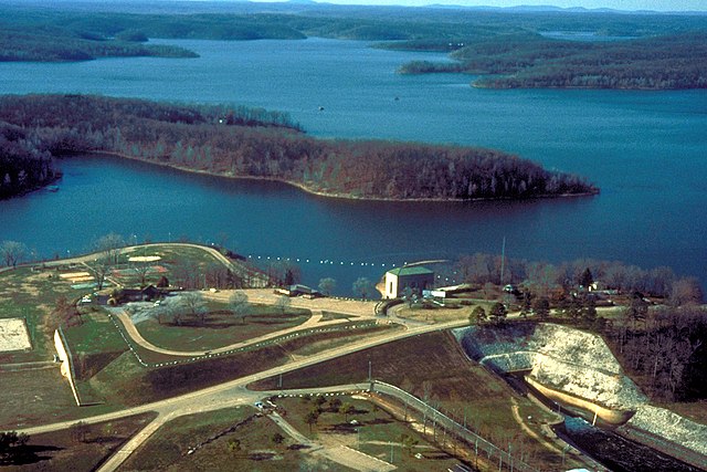
English: Wappapello Lake, near Wappapello, Missouri, USA. The lake is impounded behind Wappapello Dam, of which only the spillway is shown in this photograph. |
|||
| Date | not specified or unknown | |||
| Source |
U.S. Army Corps of Engineers Digital Visual Library Image page Image description page Digital Visual Library home page |
|||
| Author | U.S. Army Corps of Engineers, photographer not specified or unknown | |||
| Permission ( Reusing this file) |
|
|||
| Location | Wappapello, Wayne County, Missouri, USA |
| Camera location |
| View this and other nearby images on: OpenStreetMap |
|
|---|
File history
Click on a date/time to view the file as it appeared at that time.
| Date/Time | Thumbnail | Dimensions | User | Comment | |
|---|---|---|---|---|---|
| current | 02:57, 5 April 2007 |
| 1,500 × 1,000 (520 KB) | DanMS | {{Information | Description = {{en|Wappapello Lake, near Wappapello, Missouri, USA. The lake is impounded behind Wappapello Dam, of which only the spillway is shown in this photograph.}} | Source = U.S. Army Corps of Engineers Digital Visual Li |
File usage
The following pages on the English Wikipedia use this file (pages on other projects are not listed):
Global file usage
The following other wikis use this file:
- Usage on ar.wikipedia.org
- Usage on azb.wikipedia.org
- Usage on ceb.wikipedia.org
- Usage on de.wikipedia.org
- Usage on fa.wikipedia.org
- Usage on fr.wikipedia.org
- Usage on ja.wikipedia.org
- Usage on www.wikidata.org
- Usage on zh.wikipedia.org
Metadata
Size of this preview:
800 × 533 pixels. Other resolutions:
320 × 213 pixels |
640 × 427 pixels |
1,024 × 683 pixels |
1,500 × 1,000 pixels.
Original file (1,500 × 1,000 pixels, file size: 520 KB, MIME type: image/jpeg)
| This is a file from the
Wikimedia Commons. Information from its
description page there is shown below. Commons is a freely licensed media file repository. You can help. |
| Description |
English: Wappapello Lake, near Wappapello, Missouri, USA. The lake is impounded behind Wappapello Dam, of which only the spillway is shown in this photograph. |
|||
| Date | not specified or unknown | |||
| Source |
U.S. Army Corps of Engineers Digital Visual Library Image page Image description page Digital Visual Library home page |
|||
| Author | U.S. Army Corps of Engineers, photographer not specified or unknown | |||
| Permission ( Reusing this file) |
|
|||
| Location | Wappapello, Wayne County, Missouri, USA |
| Camera location |
| View this and other nearby images on: OpenStreetMap |
|
|---|
File history
Click on a date/time to view the file as it appeared at that time.
| Date/Time | Thumbnail | Dimensions | User | Comment | |
|---|---|---|---|---|---|
| current | 02:57, 5 April 2007 |
| 1,500 × 1,000 (520 KB) | DanMS | {{Information | Description = {{en|Wappapello Lake, near Wappapello, Missouri, USA. The lake is impounded behind Wappapello Dam, of which only the spillway is shown in this photograph.}} | Source = U.S. Army Corps of Engineers Digital Visual Li |
File usage
The following pages on the English Wikipedia use this file (pages on other projects are not listed):
Global file usage
The following other wikis use this file:
- Usage on ar.wikipedia.org
- Usage on azb.wikipedia.org
- Usage on ceb.wikipedia.org
- Usage on de.wikipedia.org
- Usage on fa.wikipedia.org
- Usage on fr.wikipedia.org
- Usage on ja.wikipedia.org
- Usage on www.wikidata.org
- Usage on zh.wikipedia.org