
Size of this preview:
494 × 600 pixels. Other resolutions:
198 × 240 pixels |
395 × 480 pixels |
632 × 768 pixels |
843 × 1,024 pixels |
2,326 × 2,824 pixels.
Original file (2,326 × 2,824 pixels, file size: 969 KB, MIME type: image/png)
| This is a file from the
Wikimedia Commons. Information from its
description page there is shown below. Commons is a freely licensed media file repository. You can help. |
Summary
| Description |
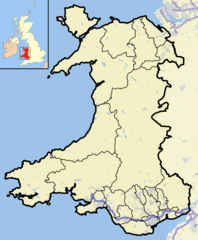
English: A map of Wales and surrounding seas and territory. Features built-up/urban areas in grey, water in light-blue, and motorways in blue with white stripe. The Principal areas of Wales, are marked in black. |
| Date | |
| Source | Own work |
| Author | Jhamez84 |
Licensing
I, the copyright holder of this work, hereby publish it under the following licenses:
This file is licensed under the
Creative Commons
Attribution-Share Alike 3.0 Unported license.
- You are free:
- to share – to copy, distribute and transmit the work
- to remix – to adapt the work
- Under the following conditions:
- attribution – You must give appropriate credit, provide a link to the license, and indicate if changes were made. You may do so in any reasonable manner, but not in any way that suggests the licensor endorses you or your use.
- share alike – If you remix, transform, or build upon the material, you must distribute your contributions under the same or compatible license as the original.

|
Permission is granted to copy, distribute and/or modify this document under the terms of the GNU Free Documentation License, Version 1.2 or any later version published by the Free Software Foundation; with no Invariant Sections, no Front-Cover Texts, and no Back-Cover Texts. A copy of the license is included in the section entitled GNU Free Documentation License. |
You may select the license of your choice.
File history
Click on a date/time to view the file as it appeared at that time.
| Date/Time | Thumbnail | Dimensions | User | Comment | |
|---|---|---|---|---|---|
| current | 00:51, 2 January 2009 |
| 2,326 × 2,824 (969 KB) | Jza84 | rm non-existent island off west coast of Marloes. |
| 14:47, 1 January 2009 |
 | 2,326 × 2,824 (971 KB) | Jza84 | +M50 motorway | |
| 14:25, 1 January 2009 |
 | 2,326 × 2,824 (972 KB) | Jza84 | +Merseyside motorway network | |
| 23:41, 31 December 2008 |
 | 2,326 × 2,824 (712 KB) | Jza84 | {{Information |Description={{en|1=A map of Wales and surrounding seas and territory. Features built-up/urban areas in grey, water in light-blue, and motorways in blue with white stripe. The Principal areas of Wales, are marked in black.}} |Source=Own work |
File usage
The following pages on the English Wikipedia use this file (pages on other projects are not listed):
- Talk:Aberdare (UK Parliament constituency)
- Talk:Abertillery (UK Parliament constituency)
- Talk:Barry (UK Parliament constituency)
- Talk:Bedwellty (UK Parliament constituency)
- Talk:Cardiff (UK Parliament constituency)
- Talk:Cardiff North West (UK Parliament constituency)
- Talk:Cardiff South (UK Parliament constituency)
- Talk:Cardiff South East (UK Parliament constituency)
- Talk:Carmarthenshire (UK Parliament constituency)
- Talk:Ceiniog
- Talk:Driscoll and Rowlands
- Talk:East Glamorganshire (UK Parliament constituency)
- Talk:Ebbw Vale (UK Parliament constituency)
- Talk:Glamorganshire (UK Parliament constituency)
- Talk:Haverfordwest (UK Parliament constituency)
- Talk:Lewistown, Bridgend
- Talk:Llandaff and Barry (UK Parliament constituency)
- Talk:MOD St Athan
- Talk:Margam Moors
- Talk:Maryland, Monmouthshire
- Talk:Merthyr (UK Parliament constituency)
- Talk:Merthyr Tydfil (UK Parliament constituency)
- Talk:Mid Glamorganshire (UK Parliament constituency)
- Talk:Monmouth Boroughs (UK Parliament constituency)
- Talk:Monmouthshire (UK Parliament constituency)
- Talk:Newport (Monmouthshire) (UK Parliament constituency)
- Talk:Neyland railway station
- Talk:North Monmouthshire (UK Parliament constituency)
- Talk:Ogwen Rural District
- Talk:Pembroke (UK Parliament constituency)
- Talk:Pembroke and Haverfordwest (UK Parliament constituency)
- Talk:Pembrokeshire (UK Parliament constituency)
- Talk:Pendraig
- Talk:Pont Llanio railway station
- Talk:Pontypool (UK Parliament constituency)
- Talk:Rhiwaedog
- Talk:Rhondda East (UK Parliament constituency)
- Talk:Rhondda West (UK Parliament constituency)
- Talk:South Glamorganshire (UK Parliament constituency)
- Talk:South Monmouthshire (UK Parliament constituency)
- Talk:St Dogmells Rural District
- Talk:Swansea (UK Parliament constituency)
- Talk:Swansea District (UK Parliament constituency)
- Talk:Tanat Valley
- Talk:West Monmouthshire (UK Parliament constituency)
- Template:WikiProject Wales
- Template talk:Infobox UK place/Archive 10
- Portal:Wales/Intro
Global file usage
The following other wikis use this file:
- Usage on arz.wikipedia.org
- Usage on fa.wikipedia.org
- Usage on ms.wikipedia.org
- Usage on yo.wikipedia.org
Size of this preview:
494 × 600 pixels. Other resolutions:
198 × 240 pixels |
395 × 480 pixels |
632 × 768 pixels |
843 × 1,024 pixels |
2,326 × 2,824 pixels.
Original file (2,326 × 2,824 pixels, file size: 969 KB, MIME type: image/png)
| This is a file from the
Wikimedia Commons. Information from its
description page there is shown below. Commons is a freely licensed media file repository. You can help. |
Summary
| Description |
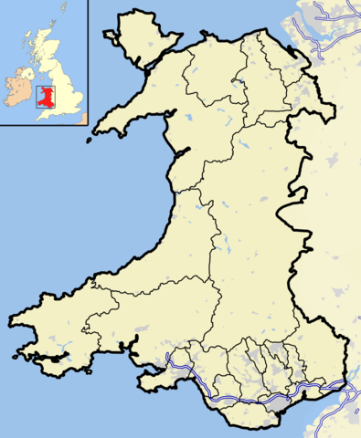
English: A map of Wales and surrounding seas and territory. Features built-up/urban areas in grey, water in light-blue, and motorways in blue with white stripe. The Principal areas of Wales, are marked in black. |
| Date | |
| Source | Own work |
| Author | Jhamez84 |
Licensing
I, the copyright holder of this work, hereby publish it under the following licenses:
This file is licensed under the
Creative Commons
Attribution-Share Alike 3.0 Unported license.
- You are free:
- to share – to copy, distribute and transmit the work
- to remix – to adapt the work
- Under the following conditions:
- attribution – You must give appropriate credit, provide a link to the license, and indicate if changes were made. You may do so in any reasonable manner, but not in any way that suggests the licensor endorses you or your use.
- share alike – If you remix, transform, or build upon the material, you must distribute your contributions under the same or compatible license as the original.
|
|
Permission is granted to copy, distribute and/or modify this document under the terms of the GNU Free Documentation License, Version 1.2 or any later version published by the Free Software Foundation; with no Invariant Sections, no Front-Cover Texts, and no Back-Cover Texts. A copy of the license is included in the section entitled GNU Free Documentation License. |
You may select the license of your choice.
File history
Click on a date/time to view the file as it appeared at that time.
| Date/Time | Thumbnail | Dimensions | User | Comment | |
|---|---|---|---|---|---|
| current | 00:51, 2 January 2009 |
| 2,326 × 2,824 (969 KB) | Jza84 | rm non-existent island off west coast of Marloes. |
| 14:47, 1 January 2009 |
| 2,326 × 2,824 (971 KB) | Jza84 | +M50 motorway | |
| 14:25, 1 January 2009 |
| 2,326 × 2,824 (972 KB) | Jza84 | +Merseyside motorway network | |
| 23:41, 31 December 2008 |
| 2,326 × 2,824 (712 KB) | Jza84 | {{Information |Description={{en|1=A map of Wales and surrounding seas and territory. Features built-up/urban areas in grey, water in light-blue, and motorways in blue with white stripe. The Principal areas of Wales, are marked in black.}} |Source=Own work |
File usage
The following pages on the English Wikipedia use this file (pages on other projects are not listed):
- Talk:Aberdare (UK Parliament constituency)
- Talk:Abertillery (UK Parliament constituency)
- Talk:Barry (UK Parliament constituency)
- Talk:Bedwellty (UK Parliament constituency)
- Talk:Cardiff (UK Parliament constituency)
- Talk:Cardiff North West (UK Parliament constituency)
- Talk:Cardiff South (UK Parliament constituency)
- Talk:Cardiff South East (UK Parliament constituency)
- Talk:Carmarthenshire (UK Parliament constituency)
- Talk:Ceiniog
- Talk:Driscoll and Rowlands
- Talk:East Glamorganshire (UK Parliament constituency)
- Talk:Ebbw Vale (UK Parliament constituency)
- Talk:Glamorganshire (UK Parliament constituency)
- Talk:Haverfordwest (UK Parliament constituency)
- Talk:Lewistown, Bridgend
- Talk:Llandaff and Barry (UK Parliament constituency)
- Talk:MOD St Athan
- Talk:Margam Moors
- Talk:Maryland, Monmouthshire
- Talk:Merthyr (UK Parliament constituency)
- Talk:Merthyr Tydfil (UK Parliament constituency)
- Talk:Mid Glamorganshire (UK Parliament constituency)
- Talk:Monmouth Boroughs (UK Parliament constituency)
- Talk:Monmouthshire (UK Parliament constituency)
- Talk:Newport (Monmouthshire) (UK Parliament constituency)
- Talk:Neyland railway station
- Talk:North Monmouthshire (UK Parliament constituency)
- Talk:Ogwen Rural District
- Talk:Pembroke (UK Parliament constituency)
- Talk:Pembroke and Haverfordwest (UK Parliament constituency)
- Talk:Pembrokeshire (UK Parliament constituency)
- Talk:Pendraig
- Talk:Pont Llanio railway station
- Talk:Pontypool (UK Parliament constituency)
- Talk:Rhiwaedog
- Talk:Rhondda East (UK Parliament constituency)
- Talk:Rhondda West (UK Parliament constituency)
- Talk:South Glamorganshire (UK Parliament constituency)
- Talk:South Monmouthshire (UK Parliament constituency)
- Talk:St Dogmells Rural District
- Talk:Swansea (UK Parliament constituency)
- Talk:Swansea District (UK Parliament constituency)
- Talk:Tanat Valley
- Talk:West Monmouthshire (UK Parliament constituency)
- Template:WikiProject Wales
- Template talk:Infobox UK place/Archive 10
- Portal:Wales/Intro
Global file usage
The following other wikis use this file:
- Usage on arz.wikipedia.org
- Usage on fa.wikipedia.org
- Usage on ms.wikipedia.org
- Usage on yo.wikipedia.org