Size of this preview:
498 × 600 pixels. Other resolutions:
199 × 240 pixels |
398 × 480 pixels |
638 × 768 pixels |
850 × 1,024 pixels |
2,000 × 2,409 pixels.
Original file (2,000 × 2,409 pixels, file size: 544 KB, MIME type: image/png)
| This is a file from the
Wikimedia Commons. Information from its
description page there is shown below. Commons is a freely licensed media file repository. You can help. |

|
This map image could be re-created using
vector graphics as an
SVG file. This has several advantages; see
Commons:Media for cleanup for more information. If an SVG form of this image is available, please upload it and afterwards replace this template with
{{
vector version available|new image name}}
.
It is recommended to name the SVG file “Verbreitung Kartenbilder Deutschland, Österreich, Schweiz.svg”—then the template Vector version available (or Vva) does not need the new image name parameter. |
Summary
| Description |
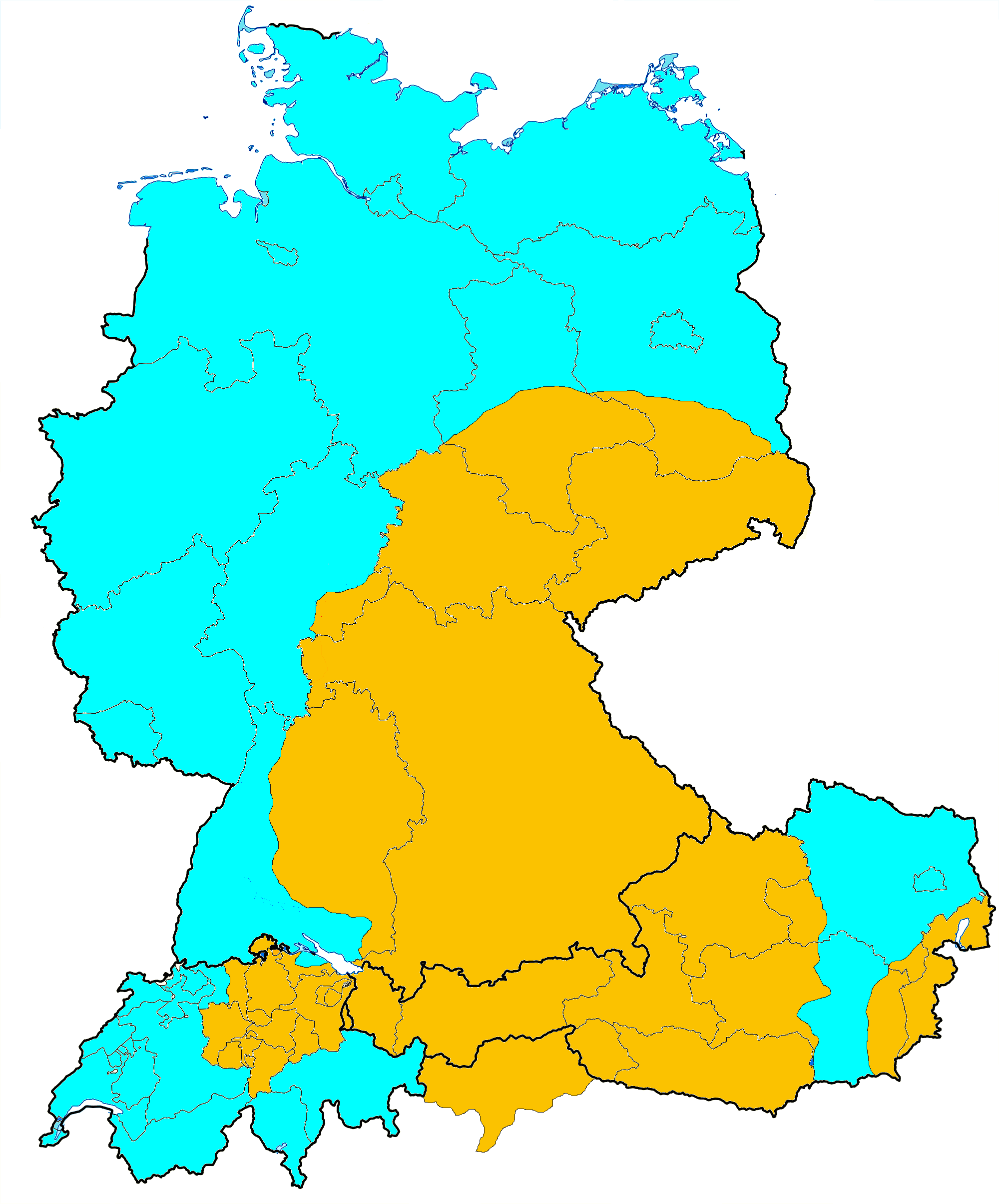
Deutsch: Verbreitung von französischen (blau) und deutschen (gelb) Kartenbildern in Deutschland, Liechtenstein, der Schweiz und Österreich (mit Südtirol). |
| Date | |
| Source | |
| Author |
|
Licensing
I, the copyright holder of this work, hereby publish it under the following licenses:

|
Permission is granted to copy, distribute and/or modify this document under the terms of the GNU Free Documentation License, Version 1.2 or any later version published by the Free Software Foundation; with no Invariant Sections, no Front-Cover Texts, and no Back-Cover Texts. A copy of the license is included in the section entitled GNU Free Documentation License. |
This file is licensed under the
Creative Commons
Attribution 3.0 Unported license.
- You are free:
- to share – to copy, distribute and transmit the work
- to remix – to adapt the work
- Under the following conditions:
- attribution – You must give appropriate credit, provide a link to the license, and indicate if changes were made. You may do so in any reasonable manner, but not in any way that suggests the licensor endorses you or your use.
You may select the license of your choice.
File history
Click on a date/time to view the file as it appeared at that time.
| Date/Time | Thumbnail | Dimensions | User | Comment | |
|---|---|---|---|---|---|
| current | 06:45, 23 September 2015 |
| 2,000 × 2,409 (544 KB) | Lupi82 | Ausbesserung Kartenbild Bayern, Raum Aschaffenburg, deutsches statt französisches Kartenbild |
| 06:45, 23 September 2015 |
 | 2,000 × 2,409 (544 KB) | Lupi82 | Ausbesserung Kartenbild Bayern, Raum Aschaffenburg, deutsches statt französisches Kartenbild | |
| 08:14, 1 September 2013 |
 | 2,000 × 2,409 (545 KB) | Lupi82 | Gelbstich weg | |
| 11:34, 20 August 2013 |
 | 2,000 × 2,409 (496 KB) | Lupi82 | {{Information |Description ={{de|1=Verbreitung von französischen (blau) und deutschen (gelb) Kartenbildern in Deutschland, der Schweiz und Österreich (mit Südtirol).}} |Source = D-A-CH_location_map.svg |Au... |
File usage
The following pages on the English Wikipedia use this file (pages on other projects are not listed):
Global file usage
The following other wikis use this file:
- Usage on cs.wikipedia.org
- Usage on de.wikipedia.org
- Usage on fi.wikipedia.org
- Usage on ru.wikipedia.org
Metadata
Size of this preview:
498 × 600 pixels. Other resolutions:
199 × 240 pixels |
398 × 480 pixels |
638 × 768 pixels |
850 × 1,024 pixels |
2,000 × 2,409 pixels.
Original file (2,000 × 2,409 pixels, file size: 544 KB, MIME type: image/png)
| This is a file from the
Wikimedia Commons. Information from its
description page there is shown below. Commons is a freely licensed media file repository. You can help. |
|
|
This map image could be re-created using
vector graphics as an
SVG file. This has several advantages; see
Commons:Media for cleanup for more information. If an SVG form of this image is available, please upload it and afterwards replace this template with
{{
vector version available|new image name}}
.
It is recommended to name the SVG file “Verbreitung Kartenbilder Deutschland, Österreich, Schweiz.svg”—then the template Vector version available (or Vva) does not need the new image name parameter. |
Summary
| Description |
Deutsch: Verbreitung von französischen (blau) und deutschen (gelb) Kartenbildern in Deutschland, Liechtenstein, der Schweiz und Österreich (mit Südtirol). |
| Date | |
| Source | |
| Author |
|
Licensing
I, the copyright holder of this work, hereby publish it under the following licenses:
|
|
Permission is granted to copy, distribute and/or modify this document under the terms of the GNU Free Documentation License, Version 1.2 or any later version published by the Free Software Foundation; with no Invariant Sections, no Front-Cover Texts, and no Back-Cover Texts. A copy of the license is included in the section entitled GNU Free Documentation License. |
This file is licensed under the
Creative Commons
Attribution 3.0 Unported license.
- You are free:
- to share – to copy, distribute and transmit the work
- to remix – to adapt the work
- Under the following conditions:
- attribution – You must give appropriate credit, provide a link to the license, and indicate if changes were made. You may do so in any reasonable manner, but not in any way that suggests the licensor endorses you or your use.
You may select the license of your choice.
File history
Click on a date/time to view the file as it appeared at that time.
| Date/Time | Thumbnail | Dimensions | User | Comment | |
|---|---|---|---|---|---|
| current | 06:45, 23 September 2015 |
| 2,000 × 2,409 (544 KB) | Lupi82 | Ausbesserung Kartenbild Bayern, Raum Aschaffenburg, deutsches statt französisches Kartenbild |
| 06:45, 23 September 2015 |
| 2,000 × 2,409 (544 KB) | Lupi82 | Ausbesserung Kartenbild Bayern, Raum Aschaffenburg, deutsches statt französisches Kartenbild | |
| 08:14, 1 September 2013 |
| 2,000 × 2,409 (545 KB) | Lupi82 | Gelbstich weg | |
| 11:34, 20 August 2013 |
| 2,000 × 2,409 (496 KB) | Lupi82 | {{Information |Description ={{de|1=Verbreitung von französischen (blau) und deutschen (gelb) Kartenbildern in Deutschland, der Schweiz und Österreich (mit Südtirol).}} |Source = D-A-CH_location_map.svg |Au... |
File usage
The following pages on the English Wikipedia use this file (pages on other projects are not listed):
Global file usage
The following other wikis use this file:
- Usage on cs.wikipedia.org
- Usage on de.wikipedia.org
- Usage on fi.wikipedia.org
- Usage on ru.wikipedia.org