Original file (500 × 646 pixels, file size: 55 KB, MIME type: image/jpeg)
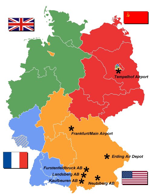
Map of the Allied Occupation Zones of Germany, 1947, with USAF air bases highlighted.
Source: Modified by author from Image:Deutschland Besatzungszonen 1945 1946.png
| I, the copyright holder of this work, hereby release it into the
public domain. This applies worldwide. If this is not legally possible: |
 | This file is a candidate to be copied to
Wikimedia Commons.
Any user may perform this transfer; refer to Wikipedia:Moving files to Commons for details. If this file has problems with attribution, copyright, or is otherwise ineligible for Commons, then remove this tag and DO NOT transfer it; repeat violators may be blocked from editing. Other Instructions
| ||
| |||
| This media file is either in the public domain or published under a free license, and contains no inbound file links. If this media file is useful, then it should be transferred to the Wikimedia Commons. If this media is not useful, then please propose it for deletion or list it at files for discussion. |
File history
Click on a date/time to view the file as it appeared at that time.
| Date/Time | Thumbnail | Dimensions | User | Comment | |
|---|---|---|---|---|---|
| current | 17:53, 1 July 2006 |
| 500 × 646 (55 KB) | Bwmoll3 ( talk | contribs) | Map of the Allied Occupation Zones of Germany, 1947, with USAF air bases highlighted. Source: Modified by author from Image:Deutschland Besatzungszonen 1945 1946.png |
You cannot overwrite this file.
File usage
Metadata
Original file (500 × 646 pixels, file size: 55 KB, MIME type: image/jpeg)
Map of the Allied Occupation Zones of Germany, 1947, with USAF air bases highlighted.
Source: Modified by author from Image:Deutschland Besatzungszonen 1945 1946.png
| I, the copyright holder of this work, hereby release it into the
public domain. This applies worldwide. If this is not legally possible: |
|
| This file is a candidate to be copied to
Wikimedia Commons.
Any user may perform this transfer; refer to Wikipedia:Moving files to Commons for details. If this file has problems with attribution, copyright, or is otherwise ineligible for Commons, then remove this tag and DO NOT transfer it; repeat violators may be blocked from editing. Other Instructions
| ||
| |||
| This media file is either in the public domain or published under a free license, and contains no inbound file links. If this media file is useful, then it should be transferred to the Wikimedia Commons. If this media is not useful, then please propose it for deletion or list it at files for discussion. |
File history
Click on a date/time to view the file as it appeared at that time.
| Date/Time | Thumbnail | Dimensions | User | Comment | |
|---|---|---|---|---|---|
| current | 17:53, 1 July 2006 |
| 500 × 646 (55 KB) | Bwmoll3 ( talk | contribs) | Map of the Allied Occupation Zones of Germany, 1947, with USAF air bases highlighted. Source: Modified by author from Image:Deutschland Besatzungszonen 1945 1946.png |
You cannot overwrite this file.