
Size of this PNG preview of this SVG file:
322 × 598 pixels. Other resolutions:
129 × 240 pixels |
258 × 480 pixels |
413 × 768 pixels |
551 × 1,024 pixels |
1,102 × 2,048 pixels |
1,233 × 2,291 pixels.
Original file (SVG file, nominally 1,233 × 2,291 pixels, file size: 45 KB)
| This is a file from the
Wikimedia Commons. Information from its
description page there is shown below. Commons is a freely licensed media file repository. You can help. |
Summary
| Description |
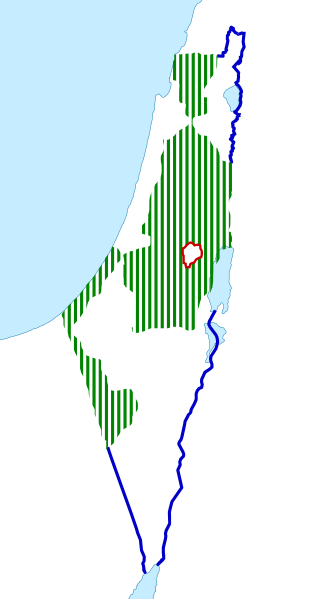
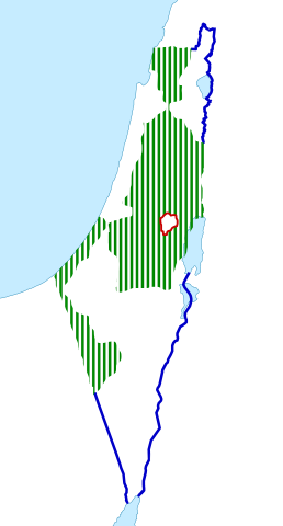
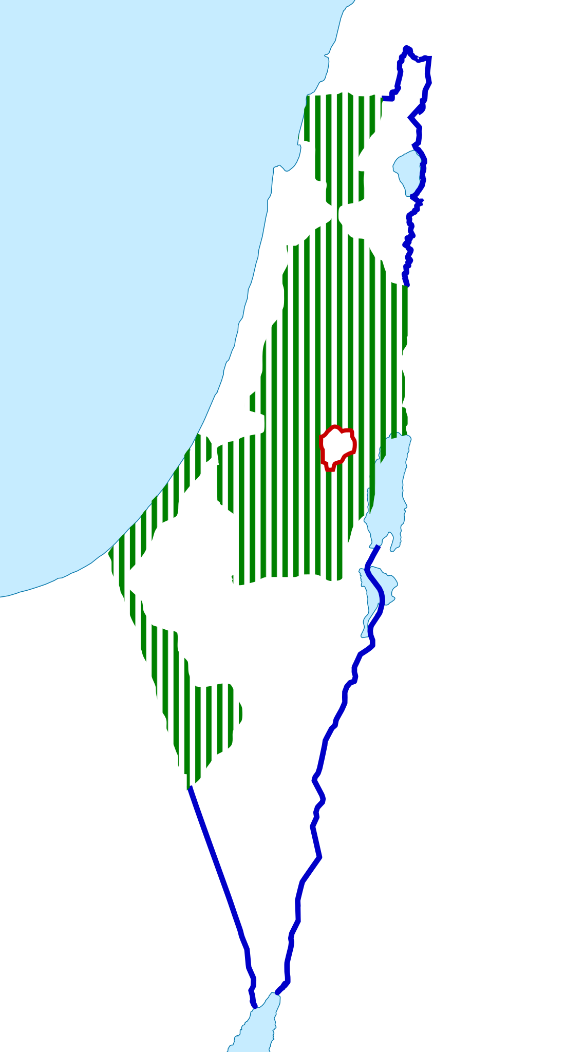
English: United Nations Partition Plan for Palestine map |
| Date | |
| Source |
Own work. This file was derived from: |
| Author | Oncenawhile |
Licensing
I, the copyright holder of this work, hereby publish it under the following license:
This file is licensed under the
Creative Commons
Attribution-Share Alike 3.0 Unported license.
- You are free:
- to share – to copy, distribute and transmit the work
- to remix – to adapt the work
- Under the following conditions:
- attribution – You must give appropriate credit, provide a link to the license, and indicate if changes were made. You may do so in any reasonable manner, but not in any way that suggests the licensor endorses you or your use.
- share alike – If you remix, transform, or build upon the material, you must distribute your contributions under the same or compatible license as the original.
File history
Click on a date/time to view the file as it appeared at that time.
| Date/Time | Thumbnail | Dimensions | User | Comment | |
|---|---|---|---|---|---|
| current | 08:46, 20 April 2014 |
| 1,233 × 2,291 (45 KB) | Mps2 | |
| 08:37, 20 April 2014 |
 | 1,233 × 2,291 (44 KB) | Mps2 | toned the colors down as this is just a proposal map used in conjunction with File:Palestinian Territories, 1948-67.svg showing the actual territory. Therefore, as both maps show slightly different things, the same colors should be avoided. | |
| 21:40, 2 March 2013 |
 | 1,233 × 2,291 (46 KB) | Onceinawhile | adding in Jerusalem international administration | |
| 21:13, 2 March 2013 |
 | 1,233 × 2,291 (45 KB) | Onceinawhile | User created page with UploadWizard |
File usage
The following pages on the English Wikipedia use this file (pages on other projects are not listed):
Global file usage
The following other wikis use this file:
- Usage on ar.wikipedia.org
- Usage on ca.wikipedia.org
- Usage on es.wikipedia.org
- Usage on eu.wikipedia.org
- Usage on fa.wikipedia.org
- Usage on it.wikipedia.org
- Usage on ms.wikipedia.org
- Usage on pnb.wikipedia.org
- Usage on pt.wikipedia.org
- Usage on sl.wikipedia.org
- Usage on sw.wikipedia.org
- Usage on th.wikipedia.org
- Usage on uk.wikipedia.org
- Usage on ur.wikipedia.org
Metadata
Size of this PNG preview of this SVG file:
322 × 598 pixels. Other resolutions:
129 × 240 pixels |
258 × 480 pixels |
413 × 768 pixels |
551 × 1,024 pixels |
1,102 × 2,048 pixels |
1,233 × 2,291 pixels.
Original file (SVG file, nominally 1,233 × 2,291 pixels, file size: 45 KB)
| This is a file from the
Wikimedia Commons. Information from its
description page there is shown below. Commons is a freely licensed media file repository. You can help. |
Summary
| Description |
English: United Nations Partition Plan for Palestine map |
| Date | |
| Source |
Own work. This file was derived from: |
| Author | Oncenawhile |
Licensing
I, the copyright holder of this work, hereby publish it under the following license:
This file is licensed under the
Creative Commons
Attribution-Share Alike 3.0 Unported license.
- You are free:
- to share – to copy, distribute and transmit the work
- to remix – to adapt the work
- Under the following conditions:
- attribution – You must give appropriate credit, provide a link to the license, and indicate if changes were made. You may do so in any reasonable manner, but not in any way that suggests the licensor endorses you or your use.
- share alike – If you remix, transform, or build upon the material, you must distribute your contributions under the same or compatible license as the original.
File history
Click on a date/time to view the file as it appeared at that time.
| Date/Time | Thumbnail | Dimensions | User | Comment | |
|---|---|---|---|---|---|
| current | 08:46, 20 April 2014 |
| 1,233 × 2,291 (45 KB) | Mps2 | |
| 08:37, 20 April 2014 |
| 1,233 × 2,291 (44 KB) | Mps2 | toned the colors down as this is just a proposal map used in conjunction with File:Palestinian Territories, 1948-67.svg showing the actual territory. Therefore, as both maps show slightly different things, the same colors should be avoided. | |
| 21:40, 2 March 2013 |
| 1,233 × 2,291 (46 KB) | Onceinawhile | adding in Jerusalem international administration | |
| 21:13, 2 March 2013 |
| 1,233 × 2,291 (45 KB) | Onceinawhile | User created page with UploadWizard |
File usage
The following pages on the English Wikipedia use this file (pages on other projects are not listed):
Global file usage
The following other wikis use this file:
- Usage on ar.wikipedia.org
- Usage on ca.wikipedia.org
- Usage on es.wikipedia.org
- Usage on eu.wikipedia.org
- Usage on fa.wikipedia.org
- Usage on it.wikipedia.org
- Usage on ms.wikipedia.org
- Usage on pnb.wikipedia.org
- Usage on pt.wikipedia.org
- Usage on sl.wikipedia.org
- Usage on sw.wikipedia.org
- Usage on th.wikipedia.org
- Usage on uk.wikipedia.org
- Usage on ur.wikipedia.org