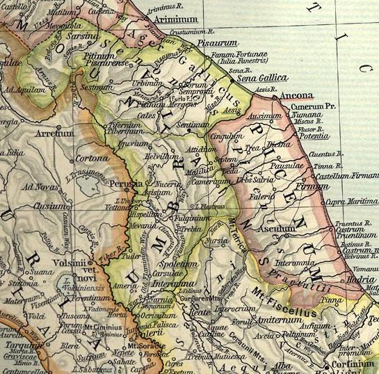
Umbria_et_Picenum.JPG (545 × 538 pixels, file size: 108 KB, MIME type: image/jpeg)
| This is a file from the
Wikimedia Commons. Information from its
description page there is shown below. Commons is a freely licensed media file repository. You can help. |
Summary
Map of Umbria et Picenum during the Roman period.
Extracted and adapted from The Historical Atlas by William R. Shepherd, 1911.
Original image is at http://www.lib.utexas.edu/maps/historical/shepherd_1911/shepherd-c-026-027.jpg
Licensing
This media file is in the
public domain in the
United States. This applies to U.S. works where the copyright has expired, often because its first
publication occurred prior to January 1, 1929, and if not then due to lack of notice or renewal. See
this page for further explanation.
|
 | |
 |
This image might not be in the public domain outside of the United States; this especially applies in the countries and areas that do not apply the
rule of the shorter term for US works, such as Canada, Mainland China (not Hong Kong or Macao), Germany, Mexico, and Switzerland. The creator and year of publication are essential information and must be provided. See
Wikipedia:Public domain and
Wikipedia:Copyrights for more details.
|
File history
Click on a date/time to view the file as it appeared at that time.
| Date/Time | Thumbnail | Dimensions | User | Comment | |
|---|---|---|---|---|---|
| current | 07:54, 1 July 2007 |
| 545 × 538 (108 KB) | Accurimbono | == Summary == Map of Umbria et Picenum during the Roman period. Extracted and adapted from ''The Historical Atlas'' by William R. Shepherd, 1911. Original image is at http://www.lib.utexas.edu/maps/historical/shepherd_1911/sheph |
File usage
Global file usage
The following other wikis use this file:
- Usage on ca.wikipedia.org
- Usage on de.wikipedia.org
- Usage on eo.wikivoyage.org
- Usage on es.wikipedia.org
- Usage on fr.wikipedia.org
- Usage on id.wikipedia.org
- Usage on it.wikipedia.org
- Ancona
- Assisi
- Acqualagna
- Provincia di Pesaro e Urbino
- Pesaro
- Urbino
- Ascoli Piceno
- Todi
- Bevagna
- Senigallia
- Civitanova Marche
- Spoleto
- Tolentino
- Martinsicuro
- Città di Castello
- Gualdo Tadino
- Nocera Umbra
- Trevi
- Narni
- Cupramontana
- Numana
- Osimo
- Cingoli
- San Severino Marche
- Cupra Marittima
- Fano
- Fossombrone
- Casentino
- Suasa
- Ager Gallicus
- Ostra antica
- Teramo
- Regio V Picenum
- Atri
- Parco archeologico di Sentinum
- Piceni
View more global usage of this file.
Metadata
Umbria_et_Picenum.JPG (545 × 538 pixels, file size: 108 KB, MIME type: image/jpeg)
| This is a file from the
Wikimedia Commons. Information from its
description page there is shown below. Commons is a freely licensed media file repository. You can help. |
Summary
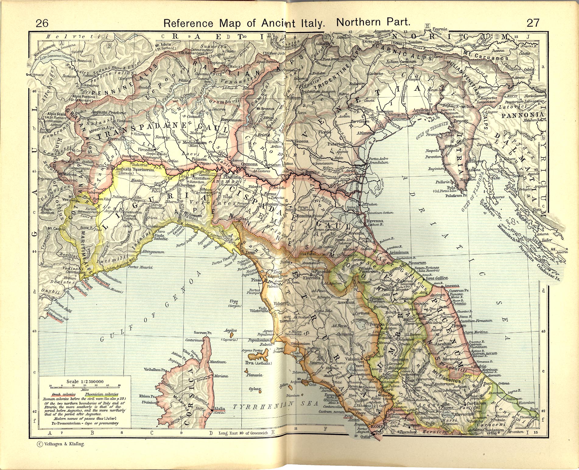
Map of Umbria et Picenum during the Roman period.
Extracted and adapted from The Historical Atlas by William R. Shepherd, 1911.
Original image is at http://www.lib.utexas.edu/maps/historical/shepherd_1911/shepherd-c-026-027.jpg
Licensing
This media file is in the
public domain in the
United States. This applies to U.S. works where the copyright has expired, often because its first
publication occurred prior to January 1, 1929, and if not then due to lack of notice or renewal. See
this page for further explanation.
|
| |
|
This image might not be in the public domain outside of the United States; this especially applies in the countries and areas that do not apply the
rule of the shorter term for US works, such as Canada, Mainland China (not Hong Kong or Macao), Germany, Mexico, and Switzerland. The creator and year of publication are essential information and must be provided. See
Wikipedia:Public domain and
Wikipedia:Copyrights for more details.
|
File history
Click on a date/time to view the file as it appeared at that time.
| Date/Time | Thumbnail | Dimensions | User | Comment | |
|---|---|---|---|---|---|
| current | 07:54, 1 July 2007 |
| 545 × 538 (108 KB) | Accurimbono | == Summary == Map of Umbria et Picenum during the Roman period. Extracted and adapted from ''The Historical Atlas'' by William R. Shepherd, 1911. Original image is at http://www.lib.utexas.edu/maps/historical/shepherd_1911/sheph |
File usage
Global file usage
The following other wikis use this file:
- Usage on ca.wikipedia.org
- Usage on de.wikipedia.org
- Usage on eo.wikivoyage.org
- Usage on es.wikipedia.org
- Usage on fr.wikipedia.org
- Usage on id.wikipedia.org
- Usage on it.wikipedia.org
- Ancona
- Assisi
- Acqualagna
- Provincia di Pesaro e Urbino
- Pesaro
- Urbino
- Ascoli Piceno
- Todi
- Bevagna
- Senigallia
- Civitanova Marche
- Spoleto
- Tolentino
- Martinsicuro
- Città di Castello
- Gualdo Tadino
- Nocera Umbra
- Trevi
- Narni
- Cupramontana
- Numana
- Osimo
- Cingoli
- San Severino Marche
- Cupra Marittima
- Fano
- Fossombrone
- Casentino
- Suasa
- Ager Gallicus
- Ostra antica
- Teramo
- Regio V Picenum
- Atri
- Parco archeologico di Sentinum
- Piceni
View more global usage of this file.