Photos • Location


Size of this preview:
800 × 534 pixels. Other resolutions:
320 × 214 pixels |
640 × 428 pixels |
1,024 × 684 pixels |
1,500 × 1,002 pixels.
Original file (1,500 × 1,002 pixels, file size: 769 KB, MIME type: image/jpeg)
| This is a file from the
Wikimedia Commons. Information from its
description page there is shown below. Commons is a freely licensed media file repository. You can help. |
| Description |
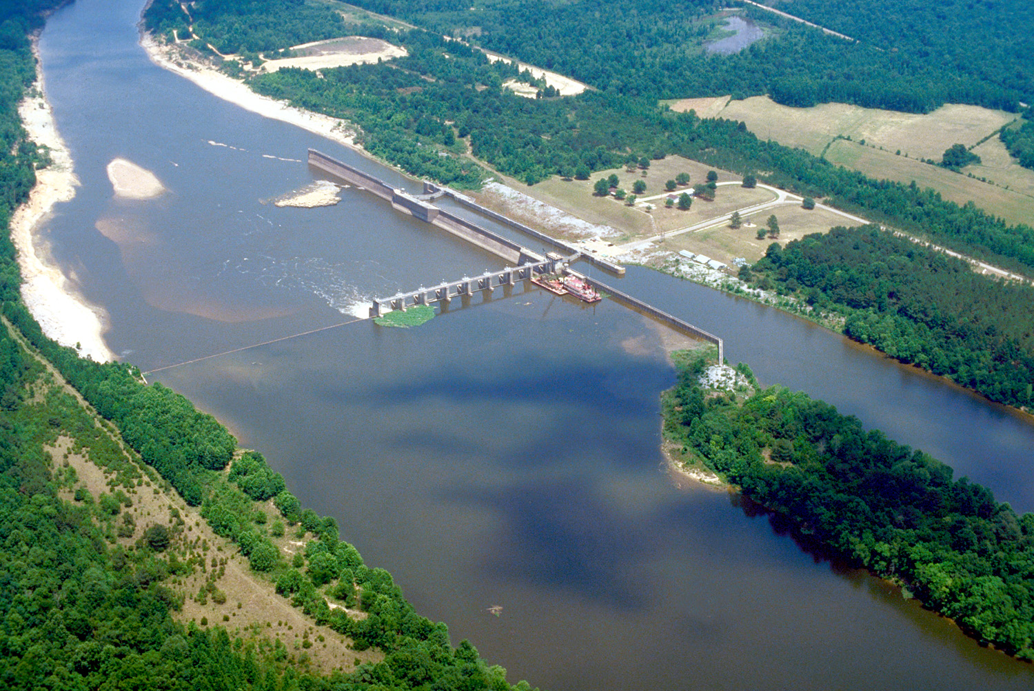
English: Aerial view of Coffeeville Lock and Dam on the Tombigbee River, spanning the border between Choctaw and Clarke Counties near Coffeeville, Alabama, USA. View is downriver to the east. The U.S. Army Corps of Engineers constructed the dam and lock on the river to provide a nine-foot navigation channel. Coffeeville Lock and Dam is the last lock and dam down the Tombigbee River (or the first, if travelling up the Tombigbee or Black Warrior River). There are no locks and dams between Coffeeville and the Gulf of Mexico. |
|||
| Location | Coffeeville, Alabama, USA 31°45′25.72″N 88°7′44.47″W / 31.7571444°N 88.1290194°W |
|||
| Date | ||||
| Source |
U.S. Army Corps of Engineers Digital Visual Library Image page Image description page Digital Visual Library home page |
|||
| Author | U.S. Army Corps of Engineers, photographer not specified or unknown | |||
| Permission ( Reusing this file) |
|
File history
Click on a date/time to view the file as it appeared at that time.
| Date/Time | Thumbnail | Dimensions | User | Comment | |
|---|---|---|---|---|---|
| current | 03:14, 19 April 2007 |
| 1,500 × 1,002 (769 KB) | DanMS | {{Information2 | Description = {{en|Aerial view of Coffeeville Lock and Dam on the Tombigbee River, spanning the border between Choctaw and Clarke Counties near Coffeefille, Alabama, USA. View is downriver to the east. The U.S. Army Corps of Engineers |
File usage
The following pages on the English Wikipedia use this file (pages on other projects are not listed):
Global file usage
The following other wikis use this file:
- Usage on arz.wikipedia.org
- Usage on bg.wikipedia.org
- Usage on ceb.wikipedia.org
- Usage on de.wikipedia.org
- Usage on es.wikipedia.org
- Usage on frr.wikipedia.org
- Usage on fr.wikipedia.org
- Usage on gl.wikipedia.org
- Usage on it.wikipedia.org
- Usage on pl.wikipedia.org
- Usage on ro.wikipedia.org
- Usage on uk.wikipedia.org
- Usage on www.wikidata.org
Metadata
Size of this preview:
800 × 534 pixels. Other resolutions:
320 × 214 pixels |
640 × 428 pixels |
1,024 × 684 pixels |
1,500 × 1,002 pixels.
Original file (1,500 × 1,002 pixels, file size: 769 KB, MIME type: image/jpeg)
| This is a file from the
Wikimedia Commons. Information from its
description page there is shown below. Commons is a freely licensed media file repository. You can help. |
| Description |
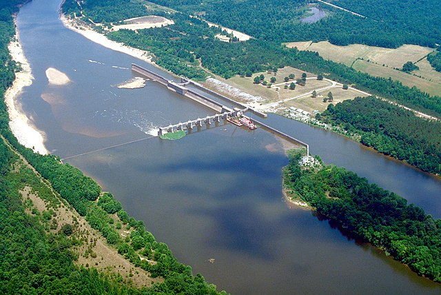
English: Aerial view of Coffeeville Lock and Dam on the Tombigbee River, spanning the border between Choctaw and Clarke Counties near Coffeeville, Alabama, USA. View is downriver to the east. The U.S. Army Corps of Engineers constructed the dam and lock on the river to provide a nine-foot navigation channel. Coffeeville Lock and Dam is the last lock and dam down the Tombigbee River (or the first, if travelling up the Tombigbee or Black Warrior River). There are no locks and dams between Coffeeville and the Gulf of Mexico. |
|||
| Location | Coffeeville, Alabama, USA 31°45′25.72″N 88°7′44.47″W / 31.7571444°N 88.1290194°W |
|||
| Date | ||||
| Source |
U.S. Army Corps of Engineers Digital Visual Library Image page Image description page Digital Visual Library home page |
|||
| Author | U.S. Army Corps of Engineers, photographer not specified or unknown | |||
| Permission ( Reusing this file) |
|
File history
Click on a date/time to view the file as it appeared at that time.
| Date/Time | Thumbnail | Dimensions | User | Comment | |
|---|---|---|---|---|---|
| current | 03:14, 19 April 2007 |
| 1,500 × 1,002 (769 KB) | DanMS | {{Information2 | Description = {{en|Aerial view of Coffeeville Lock and Dam on the Tombigbee River, spanning the border between Choctaw and Clarke Counties near Coffeefille, Alabama, USA. View is downriver to the east. The U.S. Army Corps of Engineers |
File usage
The following pages on the English Wikipedia use this file (pages on other projects are not listed):
Global file usage
The following other wikis use this file:
- Usage on arz.wikipedia.org
- Usage on bg.wikipedia.org
- Usage on ceb.wikipedia.org
- Usage on de.wikipedia.org
- Usage on es.wikipedia.org
- Usage on frr.wikipedia.org
- Usage on fr.wikipedia.org
- Usage on gl.wikipedia.org
- Usage on it.wikipedia.org
- Usage on pl.wikipedia.org
- Usage on ro.wikipedia.org
- Usage on uk.wikipedia.org
- Usage on www.wikidata.org