
Original file (4,420 × 2,337 pixels, file size: 5.85 MB, MIME type: image/jpeg)
| This is a file from the
Wikimedia Commons. Information from its
description page there is shown below. Commons is a freely licensed media file repository. You can help. |
Summary
| Description |
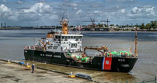
English: Barbara Mabrity
These ships are all named after Lighthousekeeper Operators: United States Coast Guard Built:1995–2000 In commission:1996–present Completed:14 Active:14 General characteristics [1] Displacement:840 long tons (850 t) Length:175 ft (53.3 m) Beam:36 ft (11.0 m) Draft:7.9 ft (2.4 m) Propulsion: 2× Caterpillar 3508TA diesel engines, 2 Z-drive thrusters 1,920 hp (1,430 kW) Speed:12 kn (22 km/h; 14 mph) Complement:24 Sensors and processing systems: |
| Date | |
| Source | https://www.flickr.com/photos/volvob12b/50705424637/ |
| Author | Bernard Spragg. NZ |
| Camera location |
| View this and other nearby images on: OpenStreetMap |
|
|---|
Licensing
| This file is made available under the Creative Commons CC0 1.0 Universal Public Domain Dedication. | |
| The person who associated a work with this deed has dedicated the work to the
public domain by waiving all of their rights to the work worldwide under copyright law, including all related and neighboring rights, to the extent allowed by law. You can copy, modify, distribute and perform the work, even for commercial purposes, all without asking permission.
|
| This image was originally posted to Flickr by Bernard Spragg at https://flickr.com/photos/88123769@N02/50705424637. It was reviewed on 16 January 2021 by FlickreviewR 2 and was confirmed to be licensed under the terms of the cc-zero. |
File history
Click on a date/time to view the file as it appeared at that time.
| Date/Time | Thumbnail | Dimensions | User | Comment | |
|---|---|---|---|---|---|
| current | 06:00, 16 January 2021 |
| 4,420 × 2,337 (5.85 MB) | Infrogmation | Uploaded a work by Bernard Spragg. NZ from https://www.flickr.com/photos/volvob12b/50705424637/ with UploadWizard |
File usage
Global file usage
The following other wikis use this file:
- Usage on www.wikidata.org
Metadata
Original file (4,420 × 2,337 pixels, file size: 5.85 MB, MIME type: image/jpeg)
| This is a file from the
Wikimedia Commons. Information from its
description page there is shown below. Commons is a freely licensed media file repository. You can help. |
Summary
| Description |
English: Barbara Mabrity
These ships are all named after Lighthousekeeper Operators: United States Coast Guard Built:1995–2000 In commission:1996–present Completed:14 Active:14 General characteristics [1] Displacement:840 long tons (850 t) Length:175 ft (53.3 m) Beam:36 ft (11.0 m) Draft:7.9 ft (2.4 m) Propulsion: 2× Caterpillar 3508TA diesel engines, 2 Z-drive thrusters 1,920 hp (1,430 kW) Speed:12 kn (22 km/h; 14 mph) Complement:24 Sensors and processing systems: |
| Date | |
| Source | https://www.flickr.com/photos/volvob12b/50705424637/ |
| Author | Bernard Spragg. NZ |
| Camera location |
| View this and other nearby images on: OpenStreetMap |
|
|---|
Licensing
| This file is made available under the Creative Commons CC0 1.0 Universal Public Domain Dedication. | |
| The person who associated a work with this deed has dedicated the work to the
public domain by waiving all of their rights to the work worldwide under copyright law, including all related and neighboring rights, to the extent allowed by law. You can copy, modify, distribute and perform the work, even for commercial purposes, all without asking permission.
|
| This image was originally posted to Flickr by Bernard Spragg at https://flickr.com/photos/88123769@N02/50705424637. It was reviewed on 16 January 2021 by FlickreviewR 2 and was confirmed to be licensed under the terms of the cc-zero. |
File history
Click on a date/time to view the file as it appeared at that time.
| Date/Time | Thumbnail | Dimensions | User | Comment | |
|---|---|---|---|---|---|
| current | 06:00, 16 January 2021 |
| 4,420 × 2,337 (5.85 MB) | Infrogmation | Uploaded a work by Bernard Spragg. NZ from https://www.flickr.com/photos/volvob12b/50705424637/ with UploadWizard |
File usage
Global file usage
The following other wikis use this file:
- Usage on www.wikidata.org