
Size of this preview:
750 × 600 pixels. Other resolutions:
300 × 240 pixels |
600 × 480 pixels |
960 × 768 pixels |
1,280 × 1,024 pixels.
Original file (1,280 × 1,024 pixels, file size: 178 KB, MIME type: image/jpeg)
| This is a file from the
Wikimedia Commons. Information from its
description page there is shown below. Commons is a freely licensed media file repository. You can help. |
Summary
| Description |
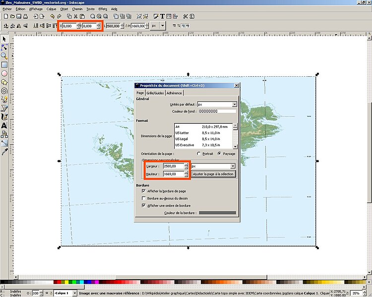
English: Screenshot made for the French speaking
Atelier graphique showing a step of a tutorial made to learn how to create a raster topographic map using
digital elevation model from the NASA.
Français : Capture d'écran réalisée dans le cadre de l´
Atelier graphique montrant une étape d'un didacticiel destiné à apprendre à créer une carte topographique bitmap à partir de
modèles numériques de terrain de la NASA ; |
| Date | |
| Source |
English: self-made – software used :
Inkscape
Français : Réalisation personnelle – logiciel utilisé :
Inkscape ; |
| Author | Eric Gaba ( Sting) |
Licensing
I, the copyright holder of this work, hereby publish it under the following licenses:

|
Permission is granted to copy, distribute and/or modify this document under the terms of the GNU Free Documentation License, Version 1.2 or any later version published by the Free Software Foundation; with no Invariant Sections, no Front-Cover Texts, and no Back-Cover Texts. A copy of the license is included in the section entitled GNU Free Documentation License. |
| This file is licensed under the Creative Commons Attribution-Share Alike 3.0 Unported license. | ||
| ||
| This licensing tag was added to this file as part of the GFDL licensing update. |
This file is licensed under the
Creative Commons Attribution-Share Alike
2.5 Generic,
2.0 Generic and
1.0 Generic license.
- You are free:
- to share – to copy, distribute and transmit the work
- to remix – to adapt the work
- Under the following conditions:
- attribution – You must give appropriate credit, provide a link to the license, and indicate if changes were made. You may do so in any reasonable manner, but not in any way that suggests the licensor endorses you or your use.
- share alike – If you remix, transform, or build upon the material, you must distribute your contributions under the same or compatible license as the original.
You may select the license of your choice.
File history
Click on a date/time to view the file as it appeared at that time.
| Date/Time | Thumbnail | Dimensions | User | Comment | |
|---|---|---|---|---|---|
| current | 00:13, 8 May 2007 |
| 1,280 × 1,024 (178 KB) | Sting | {{Information |Description= Screenshot made for the French speaking '' Atelier graphique'' showing a step of a tutorial made to learn how to create a raster topographic map using [[:en:digital elevation model|digital el |
File usage
The following pages on the English Wikipedia use this file (pages on other projects are not listed):
Global file usage
The following other wikis use this file:
- Usage on fr.wikipedia.org
- Usage on tg.wikipedia.org
Metadata
Size of this preview:
750 × 600 pixels. Other resolutions:
300 × 240 pixels |
600 × 480 pixels |
960 × 768 pixels |
1,280 × 1,024 pixels.
Original file (1,280 × 1,024 pixels, file size: 178 KB, MIME type: image/jpeg)
| This is a file from the
Wikimedia Commons. Information from its
description page there is shown below. Commons is a freely licensed media file repository. You can help. |
Summary
| Description |
English: Screenshot made for the French speaking
Atelier graphique showing a step of a tutorial made to learn how to create a raster topographic map using
digital elevation model from the NASA.
Français : Capture d'écran réalisée dans le cadre de l´
Atelier graphique montrant une étape d'un didacticiel destiné à apprendre à créer une carte topographique bitmap à partir de
modèles numériques de terrain de la NASA ; |
| Date | |
| Source |
English: self-made – software used :
Inkscape
Français : Réalisation personnelle – logiciel utilisé :
Inkscape ; |
| Author | Eric Gaba ( Sting) |
Licensing
I, the copyright holder of this work, hereby publish it under the following licenses:
|
|
Permission is granted to copy, distribute and/or modify this document under the terms of the GNU Free Documentation License, Version 1.2 or any later version published by the Free Software Foundation; with no Invariant Sections, no Front-Cover Texts, and no Back-Cover Texts. A copy of the license is included in the section entitled GNU Free Documentation License. |
| This file is licensed under the Creative Commons Attribution-Share Alike 3.0 Unported license. | ||
| ||
| This licensing tag was added to this file as part of the GFDL licensing update. |
This file is licensed under the
Creative Commons Attribution-Share Alike
2.5 Generic,
2.0 Generic and
1.0 Generic license.
- You are free:
- to share – to copy, distribute and transmit the work
- to remix – to adapt the work
- Under the following conditions:
- attribution – You must give appropriate credit, provide a link to the license, and indicate if changes were made. You may do so in any reasonable manner, but not in any way that suggests the licensor endorses you or your use.
- share alike – If you remix, transform, or build upon the material, you must distribute your contributions under the same or compatible license as the original.
You may select the license of your choice.
File history
Click on a date/time to view the file as it appeared at that time.
| Date/Time | Thumbnail | Dimensions | User | Comment | |
|---|---|---|---|---|---|
| current | 00:13, 8 May 2007 |
| 1,280 × 1,024 (178 KB) | Sting | {{Information |Description= Screenshot made for the French speaking '' Atelier graphique'' showing a step of a tutorial made to learn how to create a raster topographic map using [[:en:digital elevation model|digital el |
File usage
The following pages on the English Wikipedia use this file (pages on other projects are not listed):
Global file usage
The following other wikis use this file:
- Usage on fr.wikipedia.org
- Usage on tg.wikipedia.org