Photos • Location


No higher resolution available.
Tullymurry_Railway_Station_(ex)_-_geograph.org.uk_-_199561.jpg (640 × 480 pixels, file size: 126 KB, MIME type: image/jpeg)
| This is a file from the
Wikimedia Commons. Information from its
description page there is shown below. Commons is a freely licensed media file repository. You can help. |
_-_geograph.org.uk_-_199561.jpg)
Summary
| Description |
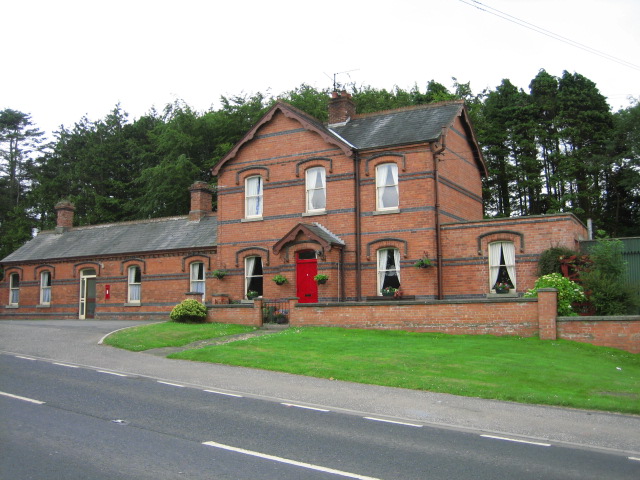
English: Tullymurry Railway Station (ex) This station was on the Belfast & County Down Railway line between Downpatrick and Newcastle. It was built in 1896 replacing an earlier station 1/4 mile SE built in 1871. The line was closed (like many others) by the Ulster Transport Authority in 1950. It has been converted to a private dwelling. |
| Date | |
| Source | From geograph.org.uk |
| Author | Brian Shaw |
| Attribution ( required by the license) | Brian Shaw / Tullymurry Railway Station (ex) / |
| Object location |
| View this and other nearby images on: OpenStreetMap |
|
|---|
_-_geograph.org.uk_-_199561.jpg¶ms=054.302000_N_-005.800000_E_globe:Earth_class:object_type:object_source:geograph-irishgrid(J4341)_&language=en)
Licensing

|
This image was taken from the
Geograph project collection. See
this photograph's page on the Geograph website for the photographer's contact details. The copyright on this image is owned by Brian Shaw and is licensed for reuse under the
Creative Commons Attribution-ShareAlike 2.0 license.
|
This file is licensed under the
Creative Commons
Attribution-Share Alike 2.0 Generic license.
Attribution: Brian Shaw
- You are free:
- to share – to copy, distribute and transmit the work
- to remix – to adapt the work
- Under the following conditions:
- attribution – You must give appropriate credit, provide a link to the license, and indicate if changes were made. You may do so in any reasonable manner, but not in any way that suggests the licensor endorses you or your use.
- share alike – If you remix, transform, or build upon the material, you must distribute your contributions under the same or compatible license as the original.
File history
Click on a date/time to view the file as it appeared at that time.
| Date/Time | Thumbnail | Dimensions | User | Comment | |
|---|---|---|---|---|---|
| current | 19:26, 31 January 2010 |
| 640 × 480 (126 KB) | GeographBot | == {{int:filedesc}} == {{Information |description={{en|1=Tullymurry Railway Station (ex) This station was on the Belfast & County Down Railway line between Downpatrick and Newcastle. It was built in 1896 replacing an earlier station 1/4 mile SE built in |
File usage
The following pages on the English Wikipedia use this file (pages on other projects are not listed):
Global file usage
The following other wikis use this file:
- Usage on www.wikidata.org
Metadata
_-_geograph.org.uk_-_199561.jpg)
No higher resolution available.
Tullymurry_Railway_Station_(ex)_-_geograph.org.uk_-_199561.jpg (640 × 480 pixels, file size: 126 KB, MIME type: image/jpeg)
| This is a file from the
Wikimedia Commons. Information from its
description page there is shown below. Commons is a freely licensed media file repository. You can help. |
Summary
| Description |
English: Tullymurry Railway Station (ex) This station was on the Belfast & County Down Railway line between Downpatrick and Newcastle. It was built in 1896 replacing an earlier station 1/4 mile SE built in 1871. The line was closed (like many others) by the Ulster Transport Authority in 1950. It has been converted to a private dwelling. |
| Date | |
| Source | From geograph.org.uk |
| Author | Brian Shaw |
| Attribution ( required by the license) | Brian Shaw / Tullymurry Railway Station (ex) / |
| Object location |
| View this and other nearby images on: OpenStreetMap |
|
|---|
Licensing
|
|
This image was taken from the
Geograph project collection. See
this photograph's page on the Geograph website for the photographer's contact details. The copyright on this image is owned by Brian Shaw and is licensed for reuse under the
Creative Commons Attribution-ShareAlike 2.0 license.
|
This file is licensed under the
Creative Commons
Attribution-Share Alike 2.0 Generic license.
Attribution: Brian Shaw
- You are free:
- to share – to copy, distribute and transmit the work
- to remix – to adapt the work
- Under the following conditions:
- attribution – You must give appropriate credit, provide a link to the license, and indicate if changes were made. You may do so in any reasonable manner, but not in any way that suggests the licensor endorses you or your use.
- share alike – If you remix, transform, or build upon the material, you must distribute your contributions under the same or compatible license as the original.
File history
Click on a date/time to view the file as it appeared at that time.
| Date/Time | Thumbnail | Dimensions | User | Comment | |
|---|---|---|---|---|---|
| current | 19:26, 31 January 2010 |
| 640 × 480 (126 KB) | GeographBot | == {{int:filedesc}} == {{Information |description={{en|1=Tullymurry Railway Station (ex) This station was on the Belfast & County Down Railway line between Downpatrick and Newcastle. It was built in 1896 replacing an earlier station 1/4 mile SE built in |
File usage
The following pages on the English Wikipedia use this file (pages on other projects are not listed):
Global file usage
The following other wikis use this file:
- Usage on www.wikidata.org