Photos • Location


Size of this preview:
626 × 599 pixels. Other resolutions:
251 × 240 pixels |
501 × 480 pixels |
802 × 768 pixels |
1,070 × 1,024 pixels |
2,140 × 2,048 pixels |
3,273 × 3,133 pixels.
Original file (3,273 × 3,133 pixels, file size: 3.12 MB, MIME type: image/jpeg)
| This is a file from the
Wikimedia Commons. Information from its
description page there is shown below. Commons is a freely licensed media file repository. You can help. |
Summary
| Description |
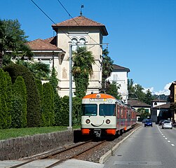
Italiano: Elettrotreno Be 4/12 della FLP in arrivo a Ponte Tresa |
| Date | |
| Source | http://www.bahnbilder.ch/picture/7001 |
| Author | Kabelleger / David Gubler ( http://www.bahnbilder.ch) |
| Camera location |
| View this and other nearby images on: OpenStreetMap |
|
|---|
Licensing
This file is licensed under the
Creative Commons
Attribution 3.0 Unported license.
- You are free:
- to share – to copy, distribute and transmit the work
- to remix – to adapt the work
- Under the following conditions:
- attribution – You must give appropriate credit, provide a link to the license, and indicate if changes were made. You may do so in any reasonable manner, but not in any way that suggests the licensor endorses you or your use.
File history
Click on a date/time to view the file as it appeared at that time.
| Date/Time | Thumbnail | Dimensions | User | Comment | |
|---|---|---|---|---|---|
| current | 14:40, 28 October 2011 |
| 3,273 × 3,133 (3.12 MB) | Arbalete |
File usage
The following pages on the English Wikipedia use this file (pages on other projects are not listed):
Global file usage
The following other wikis use this file:
- Usage on als.wikipedia.org
- Usage on de.wikipedia.org
- Usage on eo.wikipedia.org
- Usage on fr.wikipedia.org
- Usage on it.wikipedia.org
- Usage on ko.wikipedia.org
- Usage on lmo.wikipedia.org
- Usage on simple.wikipedia.org
- Usage on sv.wikipedia.org
- Usage on www.wikidata.org
Metadata
Size of this preview:
626 × 599 pixels. Other resolutions:
251 × 240 pixels |
501 × 480 pixels |
802 × 768 pixels |
1,070 × 1,024 pixels |
2,140 × 2,048 pixels |
3,273 × 3,133 pixels.
Original file (3,273 × 3,133 pixels, file size: 3.12 MB, MIME type: image/jpeg)
| This is a file from the
Wikimedia Commons. Information from its
description page there is shown below. Commons is a freely licensed media file repository. You can help. |
Summary
| Description |
Italiano: Elettrotreno Be 4/12 della FLP in arrivo a Ponte Tresa |
| Date | |
| Source | http://www.bahnbilder.ch/picture/7001 |
| Author | Kabelleger / David Gubler ( http://www.bahnbilder.ch) |
| Camera location |
| View this and other nearby images on: OpenStreetMap |
|
|---|
Licensing
This file is licensed under the
Creative Commons
Attribution 3.0 Unported license.
- You are free:
- to share – to copy, distribute and transmit the work
- to remix – to adapt the work
- Under the following conditions:
- attribution – You must give appropriate credit, provide a link to the license, and indicate if changes were made. You may do so in any reasonable manner, but not in any way that suggests the licensor endorses you or your use.
File history
Click on a date/time to view the file as it appeared at that time.
| Date/Time | Thumbnail | Dimensions | User | Comment | |
|---|---|---|---|---|---|
| current | 14:40, 28 October 2011 |
| 3,273 × 3,133 (3.12 MB) | Arbalete |
File usage
The following pages on the English Wikipedia use this file (pages on other projects are not listed):
Global file usage
The following other wikis use this file:
- Usage on als.wikipedia.org
- Usage on de.wikipedia.org
- Usage on eo.wikipedia.org
- Usage on fr.wikipedia.org
- Usage on it.wikipedia.org
- Usage on ko.wikipedia.org
- Usage on lmo.wikipedia.org
- Usage on simple.wikipedia.org
- Usage on sv.wikipedia.org
- Usage on www.wikidata.org