Original file (1,953 × 1,166 pixels, file size: 364 KB, MIME type: image/jpeg)

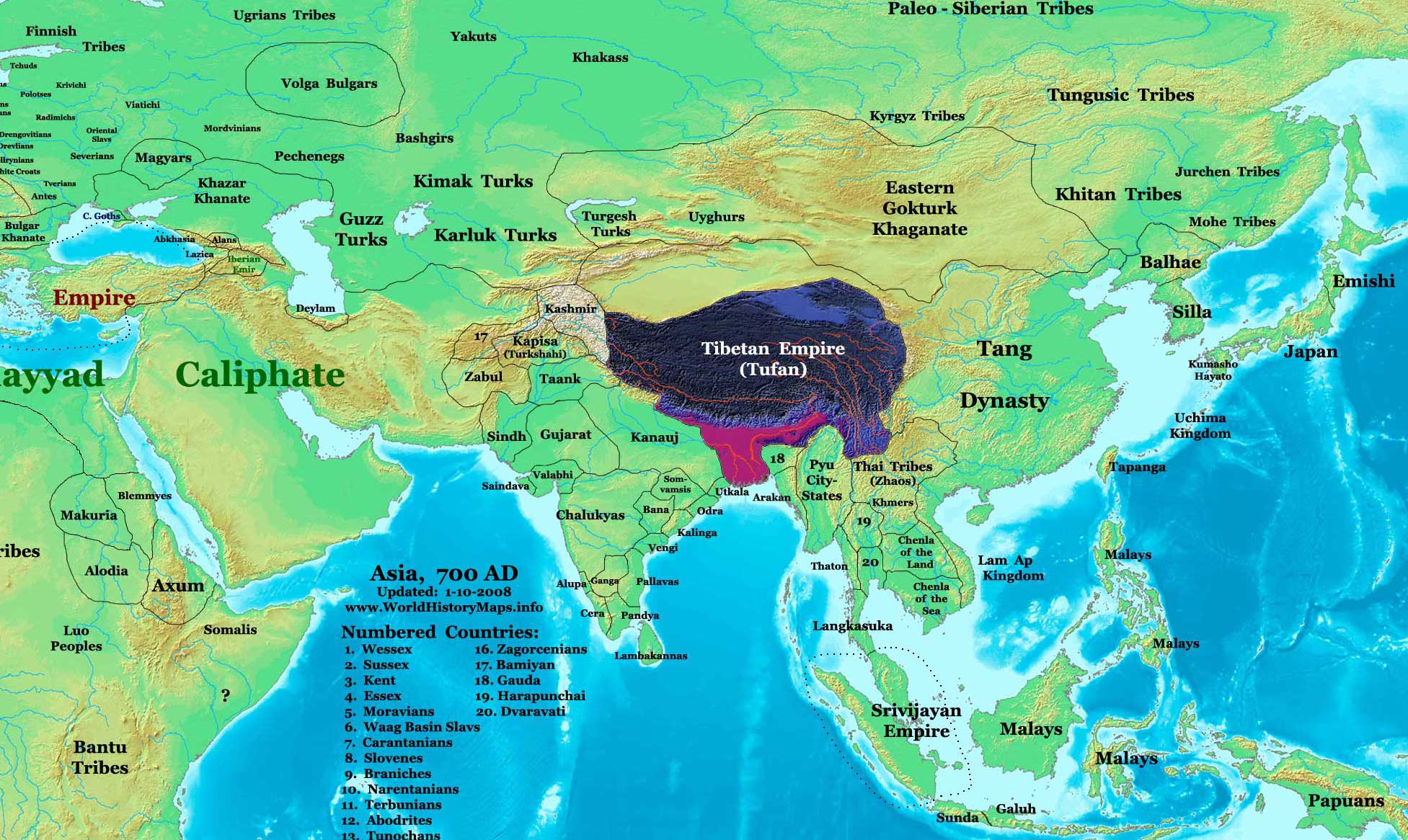
This image is a zoomed-in version of Eastern Hemisphere in 700 AD. The highlighted area is the Tibetan Empire.
Author: Thomas A. Lessman. Source URL: http://www.ThomasLessman.com/History/images/East-Hem_700ad.jpg. Image was created by me (Thomas Lessman) based on my map of Eastern Hemisphere in 700 AD. Image is free for public and/or educational use. I would appreciate a mention if this image is used elsewhere. If anyone is interested in helping further this work, please contact Thomas Lessman at talessman@yis.us.
1. [1]. 2. [2]. 3. [3]. 4. 100 BC. 5. [4]. 6. [5]. 7. [6]. 8. [7]. 9. [8]. 10. [9]. 11. [10]. 12. [11]. 13. [12]. 14. [13]. 15. [14]. 16. [15]. 17. [16]. 18. [17]. 19. [18]. 20. [19]. 21. [20]. 22. [21]. 23. [22]. (Note: the map does not represent the independent country of Nepal)
 | Permission is granted to copy, distribute and/or modify this document under the terms of the GNU Free Documentation License, Version 1.2 or any later version published by the Free Software Foundation; with no Invariant Sections, no Front-Cover Texts, and no Back-Cover Texts. |
|
| This work is licensed under the Creative Commons Attribution 3.0 License. |
 | This file is a candidate to be copied to
Wikimedia Commons.
Any user may perform this transfer; refer to Wikipedia:Moving files to Commons for details. If this file has problems with attribution, copyright, or is otherwise ineligible for Commons, then remove this tag and DO NOT transfer it; repeat violators may be blocked from editing. Other Instructions
| ||
| |||
File history
Click on a date/time to view the file as it appeared at that time.
| Date/Time | Thumbnail | Dimensions | User | Comment | |
|---|---|---|---|---|---|
| current | 23:22, 29 January 2008 |
| 1,953 × 1,166 (364 KB) | Talessman ( talk | contribs) | This image is a zoomed-in version of [http://en.wikipedia.org/wiki/Image:East-Hem_800ad.jpg Eastern Hemisphere in 800 AD]. The highlighted area is the Tibetan Empire. thumb|300px|left|Eastern Hemisphere in 800 AD. Author: T |
You cannot overwrite this file.
File usage
Metadata
Original file (1,953 × 1,166 pixels, file size: 364 KB, MIME type: image/jpeg)
This image is a zoomed-in version of Eastern Hemisphere in 700 AD. The highlighted area is the Tibetan Empire.
Author: Thomas A. Lessman. Source URL: http://www.ThomasLessman.com/History/images/East-Hem_700ad.jpg. Image was created by me (Thomas Lessman) based on my map of Eastern Hemisphere in 700 AD. Image is free for public and/or educational use. I would appreciate a mention if this image is used elsewhere. If anyone is interested in helping further this work, please contact Thomas Lessman at talessman@yis.us.
1. [1]. 2. [2]. 3. [3]. 4. 100 BC. 5. [4]. 6. [5]. 7. [6]. 8. [7]. 9. [8]. 10. [9]. 11. [10]. 12. [11]. 13. [12]. 14. [13]. 15. [14]. 16. [15]. 17. [16]. 18. [17]. 19. [18]. 20. [19]. 21. [20]. 22. [21]. 23. [22]. (Note: the map does not represent the independent country of Nepal)
|
| Permission is granted to copy, distribute and/or modify this document under the terms of the GNU Free Documentation License, Version 1.2 or any later version published by the Free Software Foundation; with no Invariant Sections, no Front-Cover Texts, and no Back-Cover Texts. |
|
| This work is licensed under the Creative Commons Attribution 3.0 License. |
|
| This file is a candidate to be copied to
Wikimedia Commons.
Any user may perform this transfer; refer to Wikipedia:Moving files to Commons for details. If this file has problems with attribution, copyright, or is otherwise ineligible for Commons, then remove this tag and DO NOT transfer it; repeat violators may be blocked from editing. Other Instructions
| ||
| |||
File history
Click on a date/time to view the file as it appeared at that time.
| Date/Time | Thumbnail | Dimensions | User | Comment | |
|---|---|---|---|---|---|
| current | 23:22, 29 January 2008 |
| 1,953 × 1,166 (364 KB) | Talessman ( talk | contribs) | This image is a zoomed-in version of [http://en.wikipedia.org/wiki/Image:East-Hem_800ad.jpg Eastern Hemisphere in 800 AD]. The highlighted area is the Tibetan Empire. thumb|300px|left|Eastern Hemisphere in 800 AD. Author: T |
You cannot overwrite this file.