
Size of this preview:
506 × 599 pixels. Other resolutions:
203 × 240 pixels |
405 × 480 pixels |
649 × 768 pixels |
865 × 1,024 pixels |
1,470 × 1,740 pixels.
Original file (1,470 × 1,740 pixels, file size: 81 KB, MIME type: image/png)
| This is a file from the
Wikimedia Commons. Information from its
description page there is shown below. Commons is a freely licensed media file repository. You can help. |
| Description |
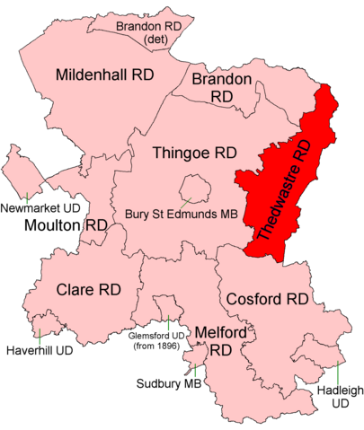
English: Thedwastre Rural District, shown within the administrative county of West Suffolk, 1894. The boundaries of Thedwastre itself were unchanged until abolition in 1974.
|
| Date | |
| Source |
Districts built up from parishes using sources cited at List of civil parishes in Suffolk. Modern parish boundaries from Ordnance Survey Boundary-Line datasets licensed under the Open Government Licence v1.0. Historic boundaries, where different, from copyright-expired (pre-1960) Ordnance Survey maps. |
| Author | Keith Edkins |
| Permission ( Reusing this file) |
This file is licensed under the
Creative Commons
Attribution-Share Alike 4.0 International license.
|
File history
Click on a date/time to view the file as it appeared at that time.
| Date/Time | Thumbnail | Dimensions | User | Comment | |
|---|---|---|---|---|---|
| current | 19:14, 8 July 2017 |
| 1,470 × 1,740 (81 KB) | Keith Edkins | {{Information |Description={{West Suffolk RDC maps 1935 commentary|Thedwastre Rural District|The boundaries of Thedwastre itself were unchanged until abolition in 1974.}} |Source=Districts built up from parishes using sources cited at [[w:List of civil... |
File usage
The following pages on the English Wikipedia use this file (pages on other projects are not listed):
Metadata
Size of this preview:
506 × 599 pixels. Other resolutions:
203 × 240 pixels |
405 × 480 pixels |
649 × 768 pixels |
865 × 1,024 pixels |
1,470 × 1,740 pixels.
Original file (1,470 × 1,740 pixels, file size: 81 KB, MIME type: image/png)
| This is a file from the
Wikimedia Commons. Information from its
description page there is shown below. Commons is a freely licensed media file repository. You can help. |
| Description |
English: Thedwastre Rural District, shown within the administrative county of West Suffolk, 1894. The boundaries of Thedwastre itself were unchanged until abolition in 1974.
|
| Date | |
| Source |
Districts built up from parishes using sources cited at List of civil parishes in Suffolk. Modern parish boundaries from Ordnance Survey Boundary-Line datasets licensed under the Open Government Licence v1.0. Historic boundaries, where different, from copyright-expired (pre-1960) Ordnance Survey maps. |
| Author | Keith Edkins |
| Permission ( Reusing this file) |
This file is licensed under the
Creative Commons
Attribution-Share Alike 4.0 International license.
|
File history
Click on a date/time to view the file as it appeared at that time.
| Date/Time | Thumbnail | Dimensions | User | Comment | |
|---|---|---|---|---|---|
| current | 19:14, 8 July 2017 |
| 1,470 × 1,740 (81 KB) | Keith Edkins | {{Information |Description={{West Suffolk RDC maps 1935 commentary|Thedwastre Rural District|The boundaries of Thedwastre itself were unchanged until abolition in 1974.}} |Source=Districts built up from parishes using sources cited at [[w:List of civil... |
File usage
The following pages on the English Wikipedia use this file (pages on other projects are not listed):