Photos • Location


Size of this preview:
800 × 495 pixels. Other resolutions:
320 × 198 pixels |
640 × 396 pixels |
1,024 × 634 pixels |
1,280 × 793 pixels |
2,560 × 1,586 pixels |
4,282 × 2,652 pixels.
Original file (4,282 × 2,652 pixels, file size: 1.72 MB, MIME type: image/jpeg)
| This is a file from the
Wikimedia Commons. Information from its
description page there is shown below. Commons is a freely licensed media file repository. You can help. |
Summary
| Description |
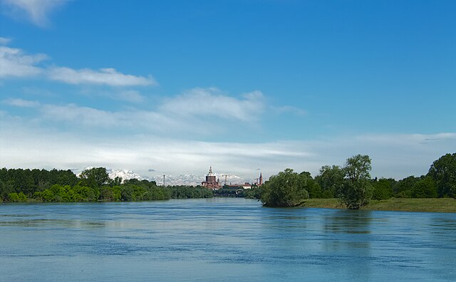
English: The straight segment of Ticino river flowing from Pavia seen from the Travaco` landing stage, near the Boschi hamlet. This is an exceptionally clear day, with the Alps, approximately 100 km to the NW, clearly visible. The Pavia skyline shows prominently the Cathedral and the S.Maria del Carmine bell tower. Other features in the foreground include Collegio Borromeo, the seaplane base "Idroscalo", and the SNAM gas pipeline bridge.
Italiano: parco naturale lombardo della Valle del Ticino (
Q3895663). La sezione rettilinea del fiume Ticino che scende da Pavia, visibile dall'imbarcadero di Travaco`, vicino alla frazione Boschi. La foto e` scattata in una giornat eccezionalmente limpida, con visibilissime le Alpi, a circa 100 km verso NO. Sul profilo di Pavia dominano la Cattedrale e il campanile di S.Maria del Carmine. Su piani progressivamente piu` vicini si vedono il Collegio Borromeo, l'Idroscalo ed il ponte del gasdotto SNAM. |
| Date | |
| Source | Own work |
| Author | Nicola Manini |
| Camera location | | View this and other nearby images on: OpenStreetMap |
|
|---|
Licensing
I, the copyright holder of this work, hereby publish it under the following license:
This file is licensed under the
Creative Commons
Attribution-Share Alike 4.0 International license.
- You are free:
- to share – to copy, distribute and transmit the work
- to remix – to adapt the work
- Under the following conditions:
- attribution – You must give appropriate credit, provide a link to the license, and indicate if changes were made. You may do so in any reasonable manner, but not in any way that suggests the licensor endorses you or your use.
- share alike – If you remix, transform, or build upon the material, you must distribute your contributions under the same or compatible license as the original.
File history
Click on a date/time to view the file as it appeared at that time.
| Date/Time | Thumbnail | Dimensions | User | Comment | |
|---|---|---|---|---|---|
| current | 22:10, 28 June 2019 |
| 4,282 × 2,652 (1.72 MB) | Nicola.Manini | User created page with UploadWizard |
File usage
The following pages on the English Wikipedia use this file (pages on other projects are not listed):
Global file usage
The following other wikis use this file:
- Usage on it.wikipedia.org
Metadata
Size of this preview:
800 × 495 pixels. Other resolutions:
320 × 198 pixels |
640 × 396 pixels |
1,024 × 634 pixels |
1,280 × 793 pixels |
2,560 × 1,586 pixels |
4,282 × 2,652 pixels.
Original file (4,282 × 2,652 pixels, file size: 1.72 MB, MIME type: image/jpeg)
| This is a file from the
Wikimedia Commons. Information from its
description page there is shown below. Commons is a freely licensed media file repository. You can help. |
Summary
| Description |
English: The straight segment of Ticino river flowing from Pavia seen from the Travaco` landing stage, near the Boschi hamlet. This is an exceptionally clear day, with the Alps, approximately 100 km to the NW, clearly visible. The Pavia skyline shows prominently the Cathedral and the S.Maria del Carmine bell tower. Other features in the foreground include Collegio Borromeo, the seaplane base "Idroscalo", and the SNAM gas pipeline bridge.
Italiano: parco naturale lombardo della Valle del Ticino (
Q3895663). La sezione rettilinea del fiume Ticino che scende da Pavia, visibile dall'imbarcadero di Travaco`, vicino alla frazione Boschi. La foto e` scattata in una giornat eccezionalmente limpida, con visibilissime le Alpi, a circa 100 km verso NO. Sul profilo di Pavia dominano la Cattedrale e il campanile di S.Maria del Carmine. Su piani progressivamente piu` vicini si vedono il Collegio Borromeo, l'Idroscalo ed il ponte del gasdotto SNAM. |
| Date | |
| Source | Own work |
| Author | Nicola Manini |
| Camera location | | View this and other nearby images on: OpenStreetMap |
|
|---|
Licensing
I, the copyright holder of this work, hereby publish it under the following license:
This file is licensed under the
Creative Commons
Attribution-Share Alike 4.0 International license.
- You are free:
- to share – to copy, distribute and transmit the work
- to remix – to adapt the work
- Under the following conditions:
- attribution – You must give appropriate credit, provide a link to the license, and indicate if changes were made. You may do so in any reasonable manner, but not in any way that suggests the licensor endorses you or your use.
- share alike – If you remix, transform, or build upon the material, you must distribute your contributions under the same or compatible license as the original.
File history
Click on a date/time to view the file as it appeared at that time.
| Date/Time | Thumbnail | Dimensions | User | Comment | |
|---|---|---|---|---|---|
| current | 22:10, 28 June 2019 |
| 4,282 × 2,652 (1.72 MB) | Nicola.Manini | User created page with UploadWizard |
File usage
The following pages on the English Wikipedia use this file (pages on other projects are not listed):
Global file usage
The following other wikis use this file:
- Usage on it.wikipedia.org