Photos • Location


No higher resolution available.
The_Perran_Foundry_-_geograph.org.uk_-_160892.jpg (640 × 427 pixels, file size: 130 KB, MIME type: image/jpeg)
| This is a file from the
Wikimedia Commons. Information from its
description page there is shown below. Commons is a freely licensed media file repository. You can help. |
Summary
| Description |
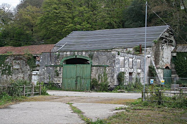
English: The Perran Foundry. This derelict industrial site awaiting "sympathetic redevelopment" is of international significance. Above the green door, the name plate shows the year 1791 as the date of establishment of the foundry. The foundry was most active from the 1820's to the 1860's when it made and shipped huge mine pumping engines all over the world. Engines created here were sent to mines in South Australia, Mexico and South Africa. Along with each engine, the company would normally send an engineer to assemble, install and run the engine.
|
|
| Date | ||
| Source | From geograph.org.uk | |
| Author | Tony Atkin | |
| Attribution ( required by the license) | Tony Atkin / The Perran Foundry / | |
| Camera location | | View this and other nearby images on: OpenStreetMap |
|
|---|
_heading:112.00&language=en)
| Object location | | View this and other nearby images on: OpenStreetMap |
|
|---|
_heading:112.00&language=en)
Licensing

|
This image was taken from the
Geograph project collection. See
this photograph's page on the Geograph website for the photographer's contact details. The copyright on this image is owned by Tony Atkin and is licensed for reuse under the
Creative Commons Attribution-ShareAlike 2.0 license.
|
This file is licensed under the
Creative Commons
Attribution-Share Alike 2.0 Generic license.
Attribution: Tony Atkin
- You are free:
- to share – to copy, distribute and transmit the work
- to remix – to adapt the work
- Under the following conditions:
- attribution – You must give appropriate credit, provide a link to the license, and indicate if changes were made. You may do so in any reasonable manner, but not in any way that suggests the licensor endorses you or your use.
- share alike – If you remix, transform, or build upon the material, you must distribute your contributions under the same or compatible license as the original.
File history
Click on a date/time to view the file as it appeared at that time.
| Date/Time | Thumbnail | Dimensions | User | Comment | |
|---|---|---|---|---|---|
| current | 12:46, 31 January 2010 |
| 640 × 427 (130 KB) | GeographBot | == {{int:filedesc}} == {{Information |description={{en|1=The Perran Foundry. This derelict industrial site awaiting "sympathetic redevelopment" is of international significance. Above the green door, the name plate shows the year 1791 as the date of esta |
File usage
The following pages on the English Wikipedia use this file (pages on other projects are not listed):
Global file usage
The following other wikis use this file:
- Usage on dag.wikipedia.org
- Usage on fa.wikipedia.org
- Usage on gd.wikipedia.org
- Usage on hr.wikipedia.org
- Usage on hy.wikipedia.org
- Usage on ru.wikipedia.org
- Usage on sco.wikipedia.org
- Usage on sh.wikipedia.org
Metadata
No higher resolution available.
The_Perran_Foundry_-_geograph.org.uk_-_160892.jpg (640 × 427 pixels, file size: 130 KB, MIME type: image/jpeg)
| This is a file from the
Wikimedia Commons. Information from its
description page there is shown below. Commons is a freely licensed media file repository. You can help. |
Summary
| Description |
English: The Perran Foundry. This derelict industrial site awaiting "sympathetic redevelopment" is of international significance. Above the green door, the name plate shows the year 1791 as the date of establishment of the foundry. The foundry was most active from the 1820's to the 1860's when it made and shipped huge mine pumping engines all over the world. Engines created here were sent to mines in South Australia, Mexico and South Africa. Along with each engine, the company would normally send an engineer to assemble, install and run the engine.
|
|
| Date | ||
| Source | From geograph.org.uk | |
| Author | Tony Atkin | |
| Attribution ( required by the license) | Tony Atkin / The Perran Foundry / | |
| Camera location | | View this and other nearby images on: OpenStreetMap |
|
|---|
| Object location | | View this and other nearby images on: OpenStreetMap |
|
|---|
Licensing
|
|
This image was taken from the
Geograph project collection. See
this photograph's page on the Geograph website for the photographer's contact details. The copyright on this image is owned by Tony Atkin and is licensed for reuse under the
Creative Commons Attribution-ShareAlike 2.0 license.
|
This file is licensed under the
Creative Commons
Attribution-Share Alike 2.0 Generic license.
Attribution: Tony Atkin
- You are free:
- to share – to copy, distribute and transmit the work
- to remix – to adapt the work
- Under the following conditions:
- attribution – You must give appropriate credit, provide a link to the license, and indicate if changes were made. You may do so in any reasonable manner, but not in any way that suggests the licensor endorses you or your use.
- share alike – If you remix, transform, or build upon the material, you must distribute your contributions under the same or compatible license as the original.
File history
Click on a date/time to view the file as it appeared at that time.
| Date/Time | Thumbnail | Dimensions | User | Comment | |
|---|---|---|---|---|---|
| current | 12:46, 31 January 2010 |
| 640 × 427 (130 KB) | GeographBot | == {{int:filedesc}} == {{Information |description={{en|1=The Perran Foundry. This derelict industrial site awaiting "sympathetic redevelopment" is of international significance. Above the green door, the name plate shows the year 1791 as the date of esta |
File usage
The following pages on the English Wikipedia use this file (pages on other projects are not listed):
Global file usage
The following other wikis use this file:
- Usage on dag.wikipedia.org
- Usage on fa.wikipedia.org
- Usage on gd.wikipedia.org
- Usage on hr.wikipedia.org
- Usage on hy.wikipedia.org
- Usage on ru.wikipedia.org
- Usage on sco.wikipedia.org
- Usage on sh.wikipedia.org