Photos • Location


Size of this preview:
570 × 599 pixels. Other resolutions:
228 × 240 pixels |
609 × 640 pixels.
Original file (609 × 640 pixels, file size: 132 KB, MIME type: image/jpeg)
| This is a file from the
Wikimedia Commons. Information from its
description page there is shown below. Commons is a freely licensed media file repository. You can help. |
Summary
| Description |
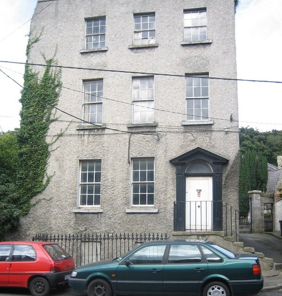
English: The House by the Churchyard The Church of Ireland, with its square tower, stands at the head of a lane way off Martin's Row in Chapelizod, just up from this gaunt three-storey house that provided the setting for Sheridan Le Fanu's novel 'The House by the Churchyard'. |
| Date | |
| Source | From geograph.org.uk |
| Author | Harold Strong |
| Attribution ( required by the license) | Harold Strong / The House by the Churchyard / |
| Camera location | | View this and other nearby images on: OpenStreetMap |
|
|---|
_heading:67.00&language=en)
| Object location | | View this and other nearby images on: OpenStreetMap |
|
|---|
_heading:67.00&language=en)
Licensing

|
This image was taken from the
Geograph project collection. See
this photograph's page on the Geograph website for the photographer's contact details. The copyright on this image is owned by Harold Strong and is licensed for reuse under the
Creative Commons Attribution-ShareAlike 2.0 license.
|
This file is licensed under the
Creative Commons
Attribution-Share Alike 2.0 Generic license.
Attribution: Harold Strong
- You are free:
- to share – to copy, distribute and transmit the work
- to remix – to adapt the work
- Under the following conditions:
- attribution – You must give appropriate credit, provide a link to the license, and indicate if changes were made. You may do so in any reasonable manner, but not in any way that suggests the licensor endorses you or your use.
- share alike – If you remix, transform, or build upon the material, you must distribute your contributions under the same or compatible license as the original.
File history
Click on a date/time to view the file as it appeared at that time.
| Date/Time | Thumbnail | Dimensions | User | Comment | |
|---|---|---|---|---|---|
| current | 21:19, 5 February 2011 |
| 609 × 640 (132 KB) | GeographBot | == {{int:filedesc}} == {{Information |description={{en|1=The House by the Churchyard The Church of Ireland, with its square tower, stands at the head of a lane way off Martin's Row in Chapelizod, just up from this gaunt three-storey house that provided t |
File usage
The following pages on the English Wikipedia use this file (pages on other projects are not listed):
Metadata
Size of this preview:
570 × 599 pixels. Other resolutions:
228 × 240 pixels |
609 × 640 pixels.
Original file (609 × 640 pixels, file size: 132 KB, MIME type: image/jpeg)
| This is a file from the
Wikimedia Commons. Information from its
description page there is shown below. Commons is a freely licensed media file repository. You can help. |
Summary
| Description |
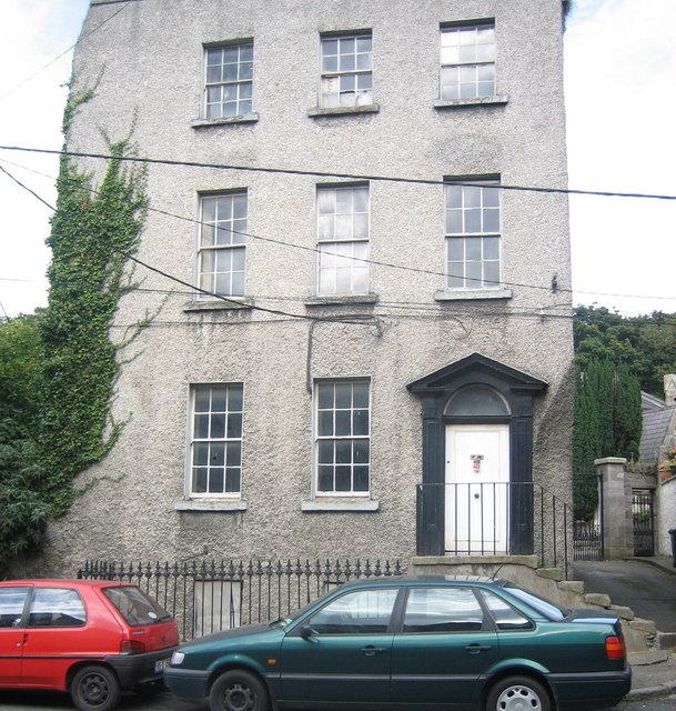
English: The House by the Churchyard The Church of Ireland, with its square tower, stands at the head of a lane way off Martin's Row in Chapelizod, just up from this gaunt three-storey house that provided the setting for Sheridan Le Fanu's novel 'The House by the Churchyard'. |
| Date | |
| Source | From geograph.org.uk |
| Author | Harold Strong |
| Attribution ( required by the license) | Harold Strong / The House by the Churchyard / |
| Camera location | | View this and other nearby images on: OpenStreetMap |
|
|---|
| Object location | | View this and other nearby images on: OpenStreetMap |
|
|---|
Licensing
|
|
This image was taken from the
Geograph project collection. See
this photograph's page on the Geograph website for the photographer's contact details. The copyright on this image is owned by Harold Strong and is licensed for reuse under the
Creative Commons Attribution-ShareAlike 2.0 license.
|
This file is licensed under the
Creative Commons
Attribution-Share Alike 2.0 Generic license.
Attribution: Harold Strong
- You are free:
- to share – to copy, distribute and transmit the work
- to remix – to adapt the work
- Under the following conditions:
- attribution – You must give appropriate credit, provide a link to the license, and indicate if changes were made. You may do so in any reasonable manner, but not in any way that suggests the licensor endorses you or your use.
- share alike – If you remix, transform, or build upon the material, you must distribute your contributions under the same or compatible license as the original.
File history
Click on a date/time to view the file as it appeared at that time.
| Date/Time | Thumbnail | Dimensions | User | Comment | |
|---|---|---|---|---|---|
| current | 21:19, 5 February 2011 |
| 609 × 640 (132 KB) | GeographBot | == {{int:filedesc}} == {{Information |description={{en|1=The House by the Churchyard The Church of Ireland, with its square tower, stands at the head of a lane way off Martin's Row in Chapelizod, just up from this gaunt three-storey house that provided t |
File usage
The following pages on the English Wikipedia use this file (pages on other projects are not listed):