
Size of this preview:
800 × 511 pixels. Other resolutions:
320 × 204 pixels |
640 × 409 pixels |
886 × 566 pixels.
Original file (886 × 566 pixels, file size: 895 KB, MIME type: image/png)
| This is a file from the
Wikimedia Commons. Information from its
description page there is shown below. Commons is a freely licensed media file repository. You can help. |
Summary
| Description |
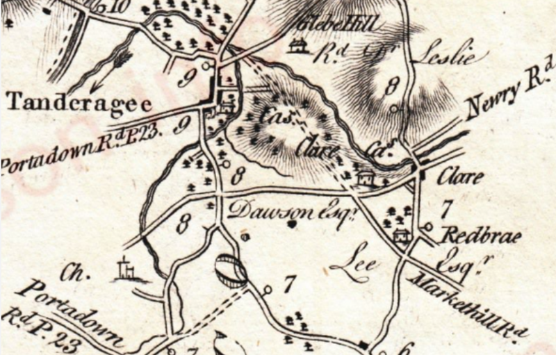
English: Map of the Tandragee area in the 18th Century |
| Date | |
| Source | https://www.swilson.info/tandsdets.php?pg=288 |
| Author | Taylor and Skinner |
Licensing
This media file is in the
public domain in the
United States. This applies to U.S. works where the copyright has expired, often because its first
publication occurred prior to January 1, 1929, and if not then due to lack of notice or renewal. See
this page for further explanation.
|
 | |
 |
This image might not be in the public domain outside of the United States; this especially applies in the countries and areas that do not apply the
rule of the shorter term for US works, such as Canada, Mainland China (not Hong Kong or Macao), Germany, Mexico, and Switzerland. The creator and year of publication are essential information and must be provided. See
Wikipedia:Public domain and
Wikipedia:Copyrights for more details.
|

|
This media file is uncategorized.
Please help improve this media file by adding it to one or more categories, so it may be associated with related media files (
how?), and so that it can be more easily found.
Please notify the uploader with {{subst:Please link images|File:Taylor and Skinner Map of Tandragee Area.png}} ~~~~ |
File history
Click on a date/time to view the file as it appeared at that time.
| Date/Time | Thumbnail | Dimensions | User | Comment | |
|---|---|---|---|---|---|
| current | 20:48, 7 July 2024 |
| 886 × 566 (895 KB) | Sharkzy | Uploaded a work by Taylor and Skinner from https://www.swilson.info/tandsdets.php?pg=288 with UploadWizard |
File usage
The following pages on the English Wikipedia use this file (pages on other projects are not listed):
Metadata
Size of this preview:
800 × 511 pixels. Other resolutions:
320 × 204 pixels |
640 × 409 pixels |
886 × 566 pixels.
Original file (886 × 566 pixels, file size: 895 KB, MIME type: image/png)
| This is a file from the
Wikimedia Commons. Information from its
description page there is shown below. Commons is a freely licensed media file repository. You can help. |
Summary
| Description |
English: Map of the Tandragee area in the 18th Century |
| Date | |
| Source | https://www.swilson.info/tandsdets.php?pg=288 |
| Author | Taylor and Skinner |
Licensing
This media file is in the
public domain in the
United States. This applies to U.S. works where the copyright has expired, often because its first
publication occurred prior to January 1, 1929, and if not then due to lack of notice or renewal. See
this page for further explanation.
|
| |
|
This image might not be in the public domain outside of the United States; this especially applies in the countries and areas that do not apply the
rule of the shorter term for US works, such as Canada, Mainland China (not Hong Kong or Macao), Germany, Mexico, and Switzerland. The creator and year of publication are essential information and must be provided. See
Wikipedia:Public domain and
Wikipedia:Copyrights for more details.
|
|
|
This media file is uncategorized.
Please help improve this media file by adding it to one or more categories, so it may be associated with related media files (
how?), and so that it can be more easily found.
Please notify the uploader with {{subst:Please link images|File:Taylor and Skinner Map of Tandragee Area.png}} ~~~~ |
File history
Click on a date/time to view the file as it appeared at that time.
| Date/Time | Thumbnail | Dimensions | User | Comment | |
|---|---|---|---|---|---|
| current | 20:48, 7 July 2024 |
| 886 × 566 (895 KB) | Sharkzy | Uploaded a work by Taylor and Skinner from https://www.swilson.info/tandsdets.php?pg=288 with UploadWizard |
File usage
The following pages on the English Wikipedia use this file (pages on other projects are not listed):