
Original file (SVG file, nominally 512 × 487 pixels, file size: 310 KB)
| This is a file from the
Wikimedia Commons. Information from its
description page there is shown below. Commons is a freely licensed media file repository. You can help. |
Summary
| Description |
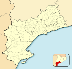
English: Location map of
Province of Tarragona
Equirectangular projection, N/S stretching 130 %. Geographic limits of the map:
Español: Mapa de localización de la
Provincia de Tarragona
Proyección equirrectangular (cilíndrica equidistante), N/S estirada 130 %. Límites geográficos del mapa:
|
|
| Date | ||
| Source | Own work based on: EspañaLoc.svg by HansenBCN | |
| Author | Miguillen | |
| SVG development | This
locator map was created with
Inkscape.
|
Licensing
- You are free:
- to share – to copy, distribute and transmit the work
- to remix – to adapt the work
- Under the following conditions:
- attribution – You must give appropriate credit, provide a link to the license, and indicate if changes were made. You may do so in any reasonable manner, but not in any way that suggests the licensor endorses you or your use.
- share alike – If you remix, transform, or build upon the material, you must distribute your contributions under the same or compatible license as the original.
File history
Click on a date/time to view the file as it appeared at that time.
| Date/Time | Thumbnail | Dimensions | User | Comment | |
|---|---|---|---|---|---|
| current | 16:22, 8 December 2010 |
| 512 × 487 (310 KB) | Miguillen | localización |
| 16:20, 8 December 2010 |
 | 512 × 487 (310 KB) | Miguillen | colores | |
| 09:49, 19 November 2010 |
 | 512 × 487 (270 KB) | Miguillen | == {{int:filedesc}} == {{Information |Description={{en|Location map of Province of Tarragona}} Equirectangular projection, N/S stretching 130 %. Geographic limits of the map: * N: ° N * S: ° N * W: ° O * E: ° O {{e |
File usage
- Alcanar
- Ascó
- Benifallet
- Buinaca
- Cambrils
- Cardó Massif
- Creu de Santos
- Deltebre
- Freginals
- L'Aldea
- La Fatarella
- La Ràpita
- La Torre de l'Espanyol
- Llorenç del Penedès
- Sant Jaume d'Enveja
- Santa Coloma de Queralt
- Tivenys
- Ulldecona
- Xerta
- Module:Location map/data/Spain Province of Tarragona
- Module:Location map/data/Spain Province of Tarragona/doc
Global file usage
The following other wikis use this file:
- Usage on ar.wikipedia.org
- Usage on ast.wikipedia.org
- Usage on ba.wikipedia.org
- Usage on ceb.wikipedia.org
- Usage on eo.wikipedia.org
- Reus
- Cunit
- Gandesa
- Ŝablono:Situo sur mapo Hispanio Provinco Taragono
- Tarragona (stacidomo)
- Reus (stacidomo)
- Tortosa
- Sant Vicenç de Calders (stacidomo)
- El Vendrell
- L'Hospitalet de l'Infant (stacidomo)
- Vandellòs i l'Hospitalet de l'Infant
- Salou-Port Aventura (stacidomo)
- Salou
- L'Arboç (stacidomo)
- L'Arboç
- Tortosa (stacidomo)
- Ulldecona-Alcanar-La Sénia (stacidomo)
- Ulldecona
- Riba-roja d'Ebre (stacidomo)
- Riba-roja d'Ebre
- Valls (stacidomo)
- Valls
- Vila-seca (stacidomo)
- Vila-seca
- El Vendrell (stacidomo)
- Torredembarra (stacidomo)
- Torredembarra
- Altafulla-Tamarit (stacidomo)
- Altafulla
- Cambrils (stacidomo)
- Cambrils
- Cunit (stacidomo)
- Calafell (stacidomo)
- Calafell
- Segur de Calafell (stacidomo)
- Montblanc (stacidomo)
- Montblanc
- L'Ametlla de Mar (stacidomo)
- L'Ametlla de Mar
- Campredó (stacidomo)
- L'Aldea-Amposta-Tortosa (stacidomo)
- L'Aldea
- L'Ampolla-Perelló-Deltebre (stacidomo)
- L'Ampolla
- Camarles-Deltebre (stacidomo)
View more global usage of this file.
Metadata
Original file (SVG file, nominally 512 × 487 pixels, file size: 310 KB)
| This is a file from the
Wikimedia Commons. Information from its
description page there is shown below. Commons is a freely licensed media file repository. You can help. |
Summary
| Description |
English: Location map of
Province of Tarragona
Equirectangular projection, N/S stretching 130 %. Geographic limits of the map:
Español: Mapa de localización de la
Provincia de Tarragona
Proyección equirrectangular (cilíndrica equidistante), N/S estirada 130 %. Límites geográficos del mapa:
|
|
| Date | ||
| Source | Own work based on: EspañaLoc.svg by HansenBCN | |
| Author | Miguillen | |
| SVG development | This
locator map was created with
Inkscape.
|
Licensing
- You are free:
- to share – to copy, distribute and transmit the work
- to remix – to adapt the work
- Under the following conditions:
- attribution – You must give appropriate credit, provide a link to the license, and indicate if changes were made. You may do so in any reasonable manner, but not in any way that suggests the licensor endorses you or your use.
- share alike – If you remix, transform, or build upon the material, you must distribute your contributions under the same or compatible license as the original.
File history
Click on a date/time to view the file as it appeared at that time.
| Date/Time | Thumbnail | Dimensions | User | Comment | |
|---|---|---|---|---|---|
| current | 16:22, 8 December 2010 |
| 512 × 487 (310 KB) | Miguillen | localización |
| 16:20, 8 December 2010 |
| 512 × 487 (310 KB) | Miguillen | colores | |
| 09:49, 19 November 2010 |
| 512 × 487 (270 KB) | Miguillen | == {{int:filedesc}} == {{Information |Description={{en|Location map of Province of Tarragona}} Equirectangular projection, N/S stretching 130 %. Geographic limits of the map: * N: ° N * S: ° N * W: ° O * E: ° O {{e |
File usage
- Alcanar
- Ascó
- Benifallet
- Buinaca
- Cambrils
- Cardó Massif
- Creu de Santos
- Deltebre
- Freginals
- L'Aldea
- La Fatarella
- La Ràpita
- La Torre de l'Espanyol
- Llorenç del Penedès
- Sant Jaume d'Enveja
- Santa Coloma de Queralt
- Tivenys
- Ulldecona
- Xerta
- Module:Location map/data/Spain Province of Tarragona
- Module:Location map/data/Spain Province of Tarragona/doc
Global file usage
The following other wikis use this file:
- Usage on ar.wikipedia.org
- Usage on ast.wikipedia.org
- Usage on ba.wikipedia.org
- Usage on ceb.wikipedia.org
- Usage on eo.wikipedia.org
- Reus
- Cunit
- Gandesa
- Ŝablono:Situo sur mapo Hispanio Provinco Taragono
- Tarragona (stacidomo)
- Reus (stacidomo)
- Tortosa
- Sant Vicenç de Calders (stacidomo)
- El Vendrell
- L'Hospitalet de l'Infant (stacidomo)
- Vandellòs i l'Hospitalet de l'Infant
- Salou-Port Aventura (stacidomo)
- Salou
- L'Arboç (stacidomo)
- L'Arboç
- Tortosa (stacidomo)
- Ulldecona-Alcanar-La Sénia (stacidomo)
- Ulldecona
- Riba-roja d'Ebre (stacidomo)
- Riba-roja d'Ebre
- Valls (stacidomo)
- Valls
- Vila-seca (stacidomo)
- Vila-seca
- El Vendrell (stacidomo)
- Torredembarra (stacidomo)
- Torredembarra
- Altafulla-Tamarit (stacidomo)
- Altafulla
- Cambrils (stacidomo)
- Cambrils
- Cunit (stacidomo)
- Calafell (stacidomo)
- Calafell
- Segur de Calafell (stacidomo)
- Montblanc (stacidomo)
- Montblanc
- L'Ametlla de Mar (stacidomo)
- L'Ametlla de Mar
- Campredó (stacidomo)
- L'Aldea-Amposta-Tortosa (stacidomo)
- L'Aldea
- L'Ampolla-Perelló-Deltebre (stacidomo)
- L'Ampolla
- Camarles-Deltebre (stacidomo)
View more global usage of this file.