
Original file (6,234 Г— 2,529 pixels, file size: 4.74 MB, MIME type: image/jpeg)
| This is a file from the
Wikimedia Commons. Information from its
description page there is shown below. Commons is a freely licensed media file repository. You can help. |
Summary
| Description |
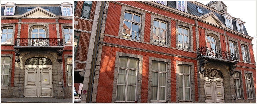
Français : Éléments classés par arrêté du 19 août 1992 : Hôtel Crombez (façades, toitures, porche et cour intérieure)
Cet ancien hôtel particulier a été construit en 1756. Sa façade classique, en briques badigeonnées et pierre, comporte six travées de deux niveaux. La travée principale est percée d’un portail en anse de panier inscrit dans un encadrement rectangulaire découpé en gorge. Deux consoles en volutes sculptées supportent un balcon dont la grille en fer forgé lui est postérieure. Répondant à la disposition du rez-de-chaussée, cette travée est percée au premier étage d’une porte, cantonnée de deux pilastres. Le tout est couronné d’un fronton triangulaire sans ornementation. La façade comporte deux cordons-larmiers qui marquent les étages et soulignent l’horizontalité de l’édifice. Les baies sont caractérisées par des linteaux échancrés et des montants appareillés. La toiture à la Mansard est percée de cinq lucarnes à fronton courbe. La cour intérieure est bordée de façades de type tournaisien (alternance de briques et calcaire de Tournai) masquées sous un épais enduit du XIXe siècle. Elles sont percées de portes-fenêtres cintrées à tympan aveugle et encadrement mouluré, de fenêtres bombées et de quatre baies postiches. La façade nord-est s’élève sur trois niveaux et est flanquée de pilastres à bossages. Le portail est caractérisé par un arc surbaissé. Source de l'information : Institut du Patrimoine wallon. Voir : http://qrwallonie.be/TOURN146 — Pour voir les photos de l'intérieur de l'immeuble, cliquez sur le signet gris ; les vues sont en bas
|
||
| Date | |||
| Source |
This file was derived from: |
||
| Author | Jpcuvelier | ||
| Other versions |
|
_%E2%80%94_H%C3%B4tel_Crombez,_rue_Saint_Piat_N%C2%B03.jpg)
_%E2%80%94_H%C3%B4tel_Crombez_au_3_rue_Saint_Piat.jpg)
_%E2%80%94_H%C3%B4tel_Crombez,_rue_Saint_Piat,_N%C2%B03.jpg)
_%E2%80%94_H%C3%B4tel_Crombez,_sis_3_rue_Saint_Piat.jpg)
| Camera location |
| View this and other nearby images on: OpenStreetMap |
|
|---|
_%E2%80%94_H%C3%B4tel_Crombez,_sis_3_rue_Saint_Piat.jpg¶ms=050.604543_N_0003.393066_E_globe:Earth_type:camera__&language=en)
Licensing
- You are free:
- to share – to copy, distribute and transmit the work
- to remix – to adapt the work
- Under the following conditions:
- attribution – You must give appropriate credit, provide a link to the license, and indicate if changes were made. You may do so in any reasonable manner, but not in any way that suggests the licensor endorses you or your use.
- share alike – If you remix, transform, or build upon the material, you must distribute your contributions under the same or compatible license as the original.
File history
Click on a date/time to view the file as it appeared at that time.
| Date/Time | Thumbnail | Dimensions | User | Comment | |
|---|---|---|---|---|---|
| current | 12:15, 1 April 2019 |
| 6,234 Г— 2,529 (4.74 MB) | Jpcuvelier | User created page with UploadWizard |
File usage
Metadata
_—_Hôtel_Crombez,_sis_3_rue_Saint_Piat.jpg)
Original file (6,234 Г— 2,529 pixels, file size: 4.74 MB, MIME type: image/jpeg)
| This is a file from the
Wikimedia Commons. Information from its
description page there is shown below. Commons is a freely licensed media file repository. You can help. |
Summary
| Description |
Français : Éléments classés par arrêté du 19 août 1992 : Hôtel Crombez (façades, toitures, porche et cour intérieure)
Cet ancien hôtel particulier a été construit en 1756. Sa façade classique, en briques badigeonnées et pierre, comporte six travées de deux niveaux. La travée principale est percée d’un portail en anse de panier inscrit dans un encadrement rectangulaire découpé en gorge. Deux consoles en volutes sculptées supportent un balcon dont la grille en fer forgé lui est postérieure. Répondant à la disposition du rez-de-chaussée, cette travée est percée au premier étage d’une porte, cantonnée de deux pilastres. Le tout est couronné d’un fronton triangulaire sans ornementation. La façade comporte deux cordons-larmiers qui marquent les étages et soulignent l’horizontalité de l’édifice. Les baies sont caractérisées par des linteaux échancrés et des montants appareillés. La toiture à la Mansard est percée de cinq lucarnes à fronton courbe. La cour intérieure est bordée de façades de type tournaisien (alternance de briques et calcaire de Tournai) masquées sous un épais enduit du XIXe siècle. Elles sont percées de portes-fenêtres cintrées à tympan aveugle et encadrement mouluré, de fenêtres bombées et de quatre baies postiches. La façade nord-est s’élève sur trois niveaux et est flanquée de pilastres à bossages. Le portail est caractérisé par un arc surbaissé. Source de l'information : Institut du Patrimoine wallon. Voir : http://qrwallonie.be/TOURN146 — Pour voir les photos de l'intérieur de l'immeuble, cliquez sur le signet gris ; les vues sont en bas
|
||
| Date | |||
| Source |
This file was derived from: |
||
| Author | Jpcuvelier | ||
| Other versions |
|
| Camera location |
| View this and other nearby images on: OpenStreetMap |
|
|---|
Licensing
- You are free:
- to share – to copy, distribute and transmit the work
- to remix – to adapt the work
- Under the following conditions:
- attribution – You must give appropriate credit, provide a link to the license, and indicate if changes were made. You may do so in any reasonable manner, but not in any way that suggests the licensor endorses you or your use.
- share alike – If you remix, transform, or build upon the material, you must distribute your contributions under the same or compatible license as the original.
File history
Click on a date/time to view the file as it appeared at that time.
| Date/Time | Thumbnail | Dimensions | User | Comment | |
|---|---|---|---|---|---|
| current | 12:15, 1 April 2019 |
| 6,234 Г— 2,529 (4.74 MB) | Jpcuvelier | User created page with UploadWizard |