
Original file (4,116 √ó 3,296 pixels, file size: 4.56 MB, MIME type: image/jpeg)
| This is a file from the
Wikimedia Commons. Information from its
description page there is shown below. Commons is a freely licensed media file repository. You can help. |
_%E2%80%94Maison_de_fondations,_sise_rue_de_Marvis_N%C2%B071.jpg)
Summary
| Description |
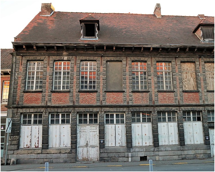
Français : Cet édifice fait partie d'un ensemble architectural construit dans le dernier quart du XVIIe siècle, typique du style louisquatorzien (encadrement des percements en pierre). Formé de trente-trois travées à l’horizontalité rigoureuse, le complexe a été fondé par les hospices civils et comporte de nombreuses ressemblances avec les maisons du quai Notre-Dame.
La maison, sur soubassement √† refends, s'√©l√®ve sur deux niveaux. Le rez-de-chauss√©e est perc√© d'une porte basse √† linteau clav√© droit surmont√©e d‚Äôune baie d‚Äôimposte soulign√©e par un larmier. Similaires √† celles de l‚Äô√©tage, les baies pr√©sentent des ch√Ęssis √† petits-bois (dont l‚Äôune est mur√©e) et sont s√©par√©es par des trumeaux simples (au rez-de-chauss√©e) et doubles (√† l‚Äô√©tage). Ces derniers, prolong√©s au niveau des all√®ges, sont reli√©s par un filet de briques. La toiture en b√Ęti√®re, support√©e par des modillons profil√©s en bois, est constitu√©e de tuiles plates et perc√©e d'une lucarne √† croupe et ailerons orn√©s de volutes. Source de l'information : Institut du Patrimoine wallon http://qrwallonie.be/TOURN086English: This building is part of an architectural complex built in the last quarter of the 17th century, typical of the Louisquatorzian style (framing of stone openings). Formed of thirty-three bays with rigorous horizontality, the complex was founded by the civil hospices and bears many similarities to the houses on the Quai Notre-Dame.
|
||
| Date | |||
| Source | Own work | ||
| Author | Jpcuvelier |
| Camera location |
| View this and other nearby images on: OpenStreetMap |
|
|---|
_%E2%80%94Maison_de_fondations,_sise_rue_de_Marvis_N%C2%B071.jpg¶ms=050.606551_N_0003.402501_E_globe:Earth_type:camera__&language=en)
Licensing
- You are free:
- to share ‚Äď to copy, distribute and transmit the work
- to remix ‚Äď to adapt the work
- Under the following conditions:
- attribution ‚Äď You must give appropriate credit, provide a link to the license, and indicate if changes were made. You may do so in any reasonable manner, but not in any way that suggests the licensor endorses you or your use.
- share alike ‚Äď If you remix, transform, or build upon the material, you must distribute your contributions under the same or compatible license as the original.
File history
Click on a date/time to view the file as it appeared at that time.
| Date/Time | Thumbnail | Dimensions | User | Comment | |
|---|---|---|---|---|---|
| current | 19:24, 25 February 2019 |
| 4,116 √ó 3,296 (4.56 MB) | Jpcuvelier | User created page with UploadWizard |
File usage
Global file usage
The following other wikis use this file:
- Usage on fr.wikipedia.org
- Usage on nl.wikipedia.org
Metadata
_‚ÄĒMaison_de_fondations,_sise_rue_de_Marvis_N¬į71.jpg)
Original file (4,116 √ó 3,296 pixels, file size: 4.56 MB, MIME type: image/jpeg)
| This is a file from the
Wikimedia Commons. Information from its
description page there is shown below. Commons is a freely licensed media file repository. You can help. |
Summary
| Description |
Français : Cet édifice fait partie d'un ensemble architectural construit dans le dernier quart du XVIIe siècle, typique du style louisquatorzien (encadrement des percements en pierre). Formé de trente-trois travées à l’horizontalité rigoureuse, le complexe a été fondé par les hospices civils et comporte de nombreuses ressemblances avec les maisons du quai Notre-Dame.
La maison, sur soubassement √† refends, s'√©l√®ve sur deux niveaux. Le rez-de-chauss√©e est perc√© d'une porte basse √† linteau clav√© droit surmont√©e d‚Äôune baie d‚Äôimposte soulign√©e par un larmier. Similaires √† celles de l‚Äô√©tage, les baies pr√©sentent des ch√Ęssis √† petits-bois (dont l‚Äôune est mur√©e) et sont s√©par√©es par des trumeaux simples (au rez-de-chauss√©e) et doubles (√† l‚Äô√©tage). Ces derniers, prolong√©s au niveau des all√®ges, sont reli√©s par un filet de briques. La toiture en b√Ęti√®re, support√©e par des modillons profil√©s en bois, est constitu√©e de tuiles plates et perc√©e d'une lucarne √† croupe et ailerons orn√©s de volutes. Source de l'information : Institut du Patrimoine wallon http://qrwallonie.be/TOURN086English: This building is part of an architectural complex built in the last quarter of the 17th century, typical of the Louisquatorzian style (framing of stone openings). Formed of thirty-three bays with rigorous horizontality, the complex was founded by the civil hospices and bears many similarities to the houses on the Quai Notre-Dame.
|
||
| Date | |||
| Source | Own work | ||
| Author | Jpcuvelier |
| Camera location |
| View this and other nearby images on: OpenStreetMap |
|
|---|
Licensing
- You are free:
- to share ‚Äď to copy, distribute and transmit the work
- to remix ‚Äď to adapt the work
- Under the following conditions:
- attribution ‚Äď You must give appropriate credit, provide a link to the license, and indicate if changes were made. You may do so in any reasonable manner, but not in any way that suggests the licensor endorses you or your use.
- share alike ‚Äď If you remix, transform, or build upon the material, you must distribute your contributions under the same or compatible license as the original.
File history
Click on a date/time to view the file as it appeared at that time.
| Date/Time | Thumbnail | Dimensions | User | Comment | |
|---|---|---|---|---|---|
| current | 19:24, 25 February 2019 |
| 4,116 √ó 3,296 (4.56 MB) | Jpcuvelier | User created page with UploadWizard |
File usage
Global file usage
The following other wikis use this file:
- Usage on fr.wikipedia.org
- Usage on nl.wikipedia.org