No higher resolution available.
Suriname-CIA_WFB_Map_(2004).png (328 × 353 pixels, file size: 9 KB, MIME type: image/png)
| This is a file from the
Wikimedia Commons. Information from its
description page there is shown below. Commons is a freely licensed media file repository. You can help. |
| Description |
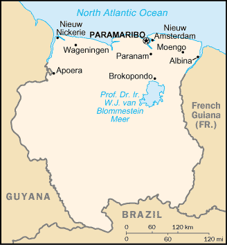
English: Map of Suriname, showing major towns. |
|||
| Date | ||||
| Source | CIA, The World Factbook, 2004 (internet version) | |||
| Author | CIA | |||
| Permission ( Reusing this file) |
|

.png)
File history
Click on a date/time to view the file as it appeared at that time.
| Date/Time | Thumbnail | Dimensions | User | Comment | |
|---|---|---|---|---|---|
| current | 01:58, 13 January 2009 |
| 328 × 353 (9 KB) | Spangineer | {{Original|Image:Suriname-CIA_WFB_Map.png|2004 version}} {{PD-USGov-CIA-WF}} Category:Maps of Suriname <!--{{ImageUpload|basic}}--> |
File usage
The following pages on the English Wikipedia use this file (pages on other projects are not listed):
Global file usage
The following other wikis use this file:
- Usage on ast.wikipedia.org
- Usage on be-tarask.wikipedia.org
- Usage on bjn.wikipedia.org
- Usage on dsb.wikipedia.org
- Usage on es.wikipedia.org
- Usage on fr.wikipedia.org
- Usage on io.wikipedia.org
- Usage on ja.wikipedia.org
- Usage on min.wikipedia.org
- Usage on os.wikipedia.org
- Usage on pt.wikipedia.org
- Usage on ro.wikipedia.org
- Usage on sr.wikipedia.org
- Usage on sw.wikipedia.org
- Usage on to.wikipedia.org
- Usage on uk.wikipedia.org
- Usage on vls.wikipedia.org
- Usage on xmf.wikipedia.org
.png)
No higher resolution available.
Suriname-CIA_WFB_Map_(2004).png (328 × 353 pixels, file size: 9 KB, MIME type: image/png)
| This is a file from the
Wikimedia Commons. Information from its
description page there is shown below. Commons is a freely licensed media file repository. You can help. |
| Description |
English: Map of Suriname, showing major towns. |
|||
| Date | ||||
| Source | CIA, The World Factbook, 2004 (internet version) | |||
| Author | CIA | |||
| Permission ( Reusing this file) |
|
File history
Click on a date/time to view the file as it appeared at that time.
| Date/Time | Thumbnail | Dimensions | User | Comment | |
|---|---|---|---|---|---|
| current | 01:58, 13 January 2009 |
| 328 × 353 (9 KB) | Spangineer | {{Original|Image:Suriname-CIA_WFB_Map.png|2004 version}} {{PD-USGov-CIA-WF}} Category:Maps of Suriname <!--{{ImageUpload|basic}}--> |
File usage
The following pages on the English Wikipedia use this file (pages on other projects are not listed):
Global file usage
The following other wikis use this file:
- Usage on ast.wikipedia.org
- Usage on be-tarask.wikipedia.org
- Usage on bjn.wikipedia.org
- Usage on dsb.wikipedia.org
- Usage on es.wikipedia.org
- Usage on fr.wikipedia.org
- Usage on io.wikipedia.org
- Usage on ja.wikipedia.org
- Usage on min.wikipedia.org
- Usage on os.wikipedia.org
- Usage on pt.wikipedia.org
- Usage on ro.wikipedia.org
- Usage on sr.wikipedia.org
- Usage on sw.wikipedia.org
- Usage on to.wikipedia.org
- Usage on uk.wikipedia.org
- Usage on vls.wikipedia.org
- Usage on xmf.wikipedia.org