Size of this preview:
588 × 600 pixels. Other resolutions:
235 × 240 pixels |
470 × 480 pixels |
738 × 753 pixels.
Original file (738 × 753 pixels, file size: 104 KB, MIME type: image/png)
| This is a file from the
Wikimedia Commons. Information from its
description page there is shown below. Commons is a freely licensed media file repository. You can help. |

|
This map image could be re-created using
vector graphics as an
SVG file. This has several advantages; see
Commons:Media for cleanup for more information. If an SVG form of this image is available, please upload it and afterwards replace this template with
{{
vector version available|new image name}}
.
It is recommended to name the SVG file “Surface-to-Air Missile Coverage over the Taiwan Strait.svg”—then the template Vector version available (or Vva) does not need the new image name parameter. |
| Description |
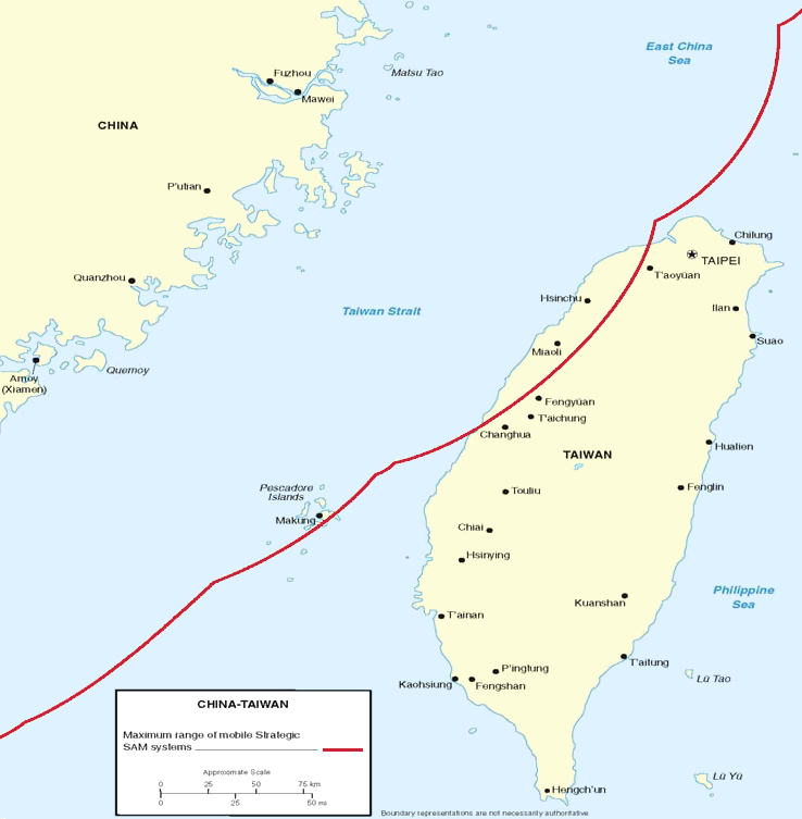
Figure 7. Surface-to-Air Missile Coverage over the Taiwan Strait. Note: This map depicts notional coverage provided by China’s SA-10, SA-20 SAM systems, as well as the soon-to-be acquired S-300PMU2. Actual coverage would be non-contiguous and dependent upon precise deployment sites. |
|||
| Date | 05/23/06 | |||
| Source | Image:China Report 2006.pdf | |||
| Author | DoD | |||
| Permission ( Reusing this file) |
|
|||
| Other versions | Derivative works of this file: Surface-to-Air Missile Coverage over the Taiwan Strait-ar.png |

File history
Click on a date/time to view the file as it appeared at that time.
| Date/Time | Thumbnail | Dimensions | User | Comment | |
|---|---|---|---|---|---|
| current | 22:15, 8 March 2018 |
| 738 × 753 (104 KB) | Ras67 | new extracted, cleaned and cropped from PDF |
| 08:40, 26 May 2006 |
 | 769 × 773 (256 KB) | Shizhao | {{Information |Description=Figure 7. Surface-to-Air Missile Coverage over the Taiwan Strait. Note: This map depicts notional coverage provided by China’s SA-10, SA-20 SAM systems, as well as the soon-to-be acquired S-300PMU2. Actual coverage would be n |
File usage
The following pages on the English Wikipedia use this file (pages on other projects are not listed):
Global file usage
The following other wikis use this file:
- Usage on es.wikipedia.org
- Usage on hu.wikipedia.org
- Usage on ja.wikipedia.org
- Usage on ko.wikipedia.org
- Usage on nov.wikipedia.org
- Usage on pt.wikipedia.org
- Usage on vi.wikipedia.org
- Usage on zh-yue.wikipedia.org
- Usage on zh.wikipedia.org
Metadata
Size of this preview:
588 × 600 pixels. Other resolutions:
235 × 240 pixels |
470 × 480 pixels |
738 × 753 pixels.
Original file (738 × 753 pixels, file size: 104 KB, MIME type: image/png)
| This is a file from the
Wikimedia Commons. Information from its
description page there is shown below. Commons is a freely licensed media file repository. You can help. |
|
|
This map image could be re-created using
vector graphics as an
SVG file. This has several advantages; see
Commons:Media for cleanup for more information. If an SVG form of this image is available, please upload it and afterwards replace this template with
{{
vector version available|new image name}}
.
It is recommended to name the SVG file “Surface-to-Air Missile Coverage over the Taiwan Strait.svg”—then the template Vector version available (or Vva) does not need the new image name parameter. |
| Description |
Figure 7. Surface-to-Air Missile Coverage over the Taiwan Strait. Note: This map depicts notional coverage provided by China’s SA-10, SA-20 SAM systems, as well as the soon-to-be acquired S-300PMU2. Actual coverage would be non-contiguous and dependent upon precise deployment sites. |
|||
| Date | 05/23/06 | |||
| Source | Image:China Report 2006.pdf | |||
| Author | DoD | |||
| Permission ( Reusing this file) |
|
|||
| Other versions | Derivative works of this file: Surface-to-Air Missile Coverage over the Taiwan Strait-ar.png |
File history
Click on a date/time to view the file as it appeared at that time.
| Date/Time | Thumbnail | Dimensions | User | Comment | |
|---|---|---|---|---|---|
| current | 22:15, 8 March 2018 |
| 738 × 753 (104 KB) | Ras67 | new extracted, cleaned and cropped from PDF |
| 08:40, 26 May 2006 |
| 769 × 773 (256 KB) | Shizhao | {{Information |Description=Figure 7. Surface-to-Air Missile Coverage over the Taiwan Strait. Note: This map depicts notional coverage provided by China’s SA-10, SA-20 SAM systems, as well as the soon-to-be acquired S-300PMU2. Actual coverage would be n |
File usage
The following pages on the English Wikipedia use this file (pages on other projects are not listed):
Global file usage
The following other wikis use this file:
- Usage on es.wikipedia.org
- Usage on hu.wikipedia.org
- Usage on ja.wikipedia.org
- Usage on ko.wikipedia.org
- Usage on nov.wikipedia.org
- Usage on pt.wikipedia.org
- Usage on vi.wikipedia.org
- Usage on zh-yue.wikipedia.org
- Usage on zh.wikipedia.org