
Size of this preview:
702 × 600 pixels. Other resolutions:
281 × 240 pixels |
562 × 480 pixels |
899 × 768 pixels |
1,199 × 1,024 pixels |
2,397 × 2,048 pixels |
3,400 × 2,905 pixels.
Original file (3,400 × 2,905 pixels, file size: 669 KB, MIME type: image/png)
| This is a file from the
Wikimedia Commons. Information from its
description page there is shown below. Commons is a freely licensed media file repository. You can help. |
Summary
| Description |
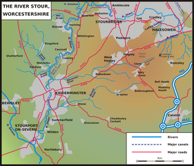
English: Sketch map of the course of the River Stour, Worcestershire, Staffordshire and West Midlands, England, UK. |
| Date | |
| Source | Own work |
| Author | Sjwells53 |
Licensing
I, the copyright holder of this work, hereby publish it under the following licenses:
This file is licensed under the
Creative Commons
Attribution-Share Alike 3.0 Unported license.
- You are free:
- to share – to copy, distribute and transmit the work
- to remix – to adapt the work
- Under the following conditions:
- attribution – You must give appropriate credit, provide a link to the license, and indicate if changes were made. You may do so in any reasonable manner, but not in any way that suggests the licensor endorses you or your use.
- share alike – If you remix, transform, or build upon the material, you must distribute your contributions under the same or compatible license as the original.

|
Permission is granted to copy, distribute and/or modify this document under the terms of the GNU Free Documentation License, Version 1.2 or any later version published by the Free Software Foundation; with no Invariant Sections, no Front-Cover Texts, and no Back-Cover Texts. A copy of the license is included in the section entitled GNU Free Documentation License. |
You may select the license of your choice.
File history
Click on a date/time to view the file as it appeared at that time.
| Date/Time | Thumbnail | Dimensions | User | Comment | |
|---|---|---|---|---|---|
| current | 11:15, 6 July 2009 |
| 3,400 × 2,905 (669 KB) | Sjwells53 | Frame restored |
| 11:04, 6 July 2009 |
 | 3,400 × 2,905 (677 KB) | Sjwells53 | Improved coverage of tributaries | |
| 22:00, 2 July 2009 |
 | 3,400 × 2,905 (652 KB) | Sjwells53 | Small labelling improvements | |
| 16:42, 2 July 2009 |
 | 3,400 × 2,905 (653 KB) | Sjwells53 | Added tributaries. | |
| 15:28, 1 July 2009 |
 | 3,400 × 2,905 (614 KB) | Sjwells53 | {{Information |Description={{en|1=Sketch map of the course of the River Stour, Worcestershire, Staffordshire and West Midlands, England, UK.}} |Source=Own work by uploader |Author= Sjwells53 |Date=July 2009 |Permission= |other_versions= |
File usage
The following pages on the English Wikipedia use this file (pages on other projects are not listed):
Global file usage
The following other wikis use this file:
- Usage on fr.wikipedia.org
- Usage on it.wikipedia.org
- Usage on sh.wikipedia.org
Size of this preview:
702 × 600 pixels. Other resolutions:
281 × 240 pixels |
562 × 480 pixels |
899 × 768 pixels |
1,199 × 1,024 pixels |
2,397 × 2,048 pixels |
3,400 × 2,905 pixels.
Original file (3,400 × 2,905 pixels, file size: 669 KB, MIME type: image/png)
| This is a file from the
Wikimedia Commons. Information from its
description page there is shown below. Commons is a freely licensed media file repository. You can help. |
Summary
| Description |
English: Sketch map of the course of the River Stour, Worcestershire, Staffordshire and West Midlands, England, UK. |
| Date | |
| Source | Own work |
| Author | Sjwells53 |
Licensing
I, the copyright holder of this work, hereby publish it under the following licenses:
This file is licensed under the
Creative Commons
Attribution-Share Alike 3.0 Unported license.
- You are free:
- to share – to copy, distribute and transmit the work
- to remix – to adapt the work
- Under the following conditions:
- attribution – You must give appropriate credit, provide a link to the license, and indicate if changes were made. You may do so in any reasonable manner, but not in any way that suggests the licensor endorses you or your use.
- share alike – If you remix, transform, or build upon the material, you must distribute your contributions under the same or compatible license as the original.
|
|
Permission is granted to copy, distribute and/or modify this document under the terms of the GNU Free Documentation License, Version 1.2 or any later version published by the Free Software Foundation; with no Invariant Sections, no Front-Cover Texts, and no Back-Cover Texts. A copy of the license is included in the section entitled GNU Free Documentation License. |
You may select the license of your choice.
File history
Click on a date/time to view the file as it appeared at that time.
| Date/Time | Thumbnail | Dimensions | User | Comment | |
|---|---|---|---|---|---|
| current | 11:15, 6 July 2009 |
| 3,400 × 2,905 (669 KB) | Sjwells53 | Frame restored |
| 11:04, 6 July 2009 |
| 3,400 × 2,905 (677 KB) | Sjwells53 | Improved coverage of tributaries | |
| 22:00, 2 July 2009 |
| 3,400 × 2,905 (652 KB) | Sjwells53 | Small labelling improvements | |
| 16:42, 2 July 2009 |
| 3,400 × 2,905 (653 KB) | Sjwells53 | Added tributaries. | |
| 15:28, 1 July 2009 |
| 3,400 × 2,905 (614 KB) | Sjwells53 | {{Information |Description={{en|1=Sketch map of the course of the River Stour, Worcestershire, Staffordshire and West Midlands, England, UK.}} |Source=Own work by uploader |Author= Sjwells53 |Date=July 2009 |Permission= |other_versions= |
File usage
The following pages on the English Wikipedia use this file (pages on other projects are not listed):
Global file usage
The following other wikis use this file:
- Usage on fr.wikipedia.org
- Usage on it.wikipedia.org
- Usage on sh.wikipedia.org